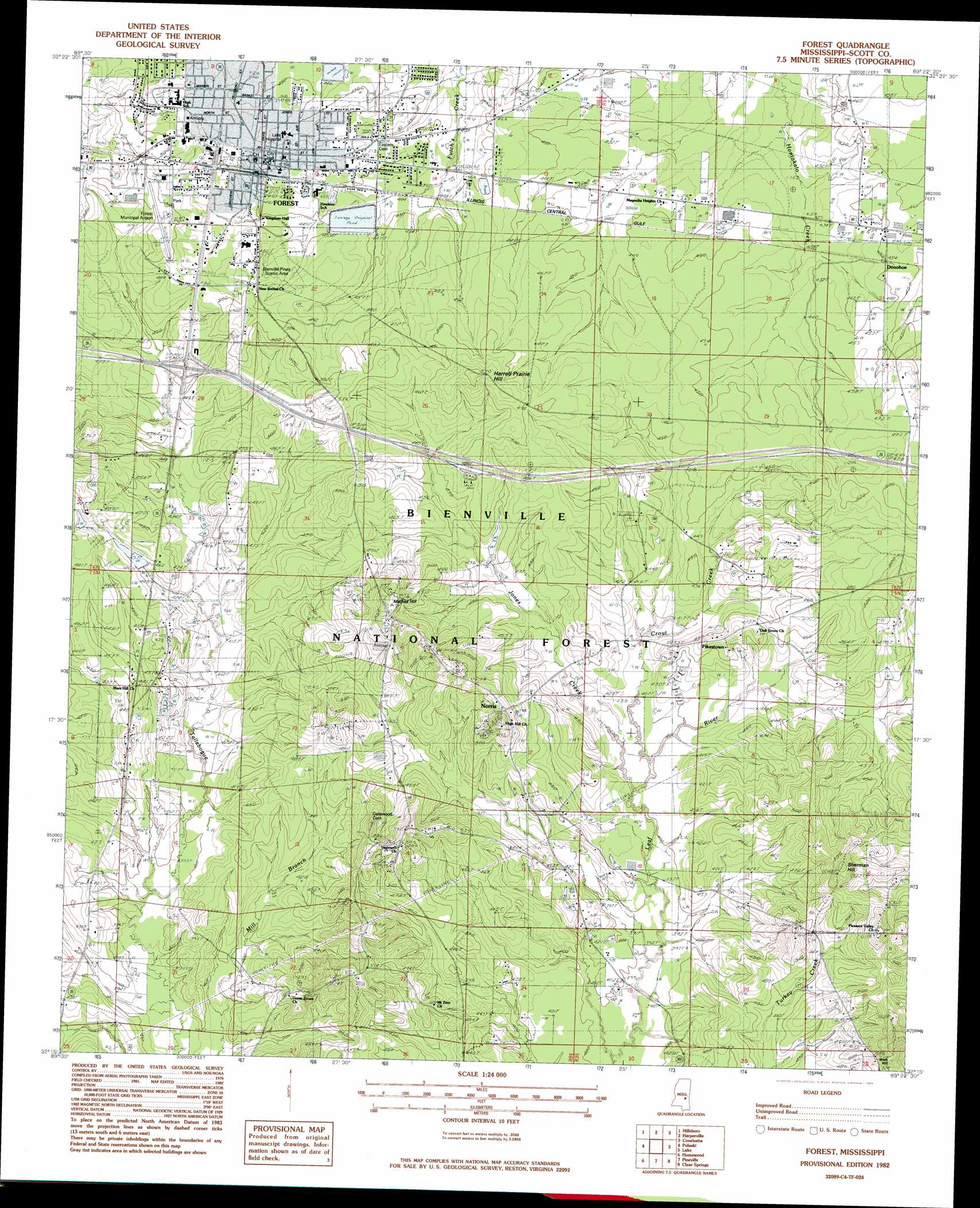
Forest Topo Map Mississippi
To zoom in, hover over the map of Forest
USGS Topo Quad 32089c4 - 1:24,000 scale
| Topo Map Name: | Forest |
| USGS Topo Quad ID: | 32089c4 |
| Print Size: | ca. 21 1/4" wide x 27" high |
| Southeast Coordinates: | 32.25° N latitude / 89.375° W longitude |
| Map Center Coordinates: | 32.3125° N latitude / 89.4375° W longitude |
| U.S. State: | MS |
| Filename: | o32089c4.jpg |
| Download Map JPG Image: | Forest topo map 1:24,000 scale |
| Map Type: | Topographic |
| Topo Series: | 7.5´ |
| Map Scale: | 1:24,000 |
| Source of Map Images: | United States Geological Survey (USGS) |
| Alternate Map Versions: |
Forest MS 1982, updated 1983 Download PDF Buy paper map Forest MS 1982, updated 1983 Download PDF Buy paper map Forest MS 2000, updated 2002 Download PDF Buy paper map Forest MS 2012 Download PDF Buy paper map Forest MS 2015 Download PDF Buy paper map |
| FStopo: | US Forest Service topo Forest is available: Download FStopo PDF Download FStopo TIF |
1:24,000 Topo Quads surrounding Forest
Ludlow |
Lena |
Walnut Grove |
Sebastopol |
Union West |
Forkville |
Hillsboro |
Harperville |
Conehatta |
Decatur Nw |
Morton |
Pulaski |
Forest |
Lake |
Newton |
Polkville |
Homewood |
Pineville |
Clear Springs |
Montrose North |
White Oak |
Raleigh |
Louin Sw |
Louin |
Montrose South |
> Back to 32089a1 at 1:100,000 scale
> Back to 32088a1 at 1:250,000 scale
> Back to U.S. Topo Maps home
Forest topo map: Gazetteer
Forest: Airports
Forest Municipal Airport elevation 156m 511′Forest: Crossings
Interchange 88 elevation 142m 465′Forest: Dams
Forest Country Club Lake Dam elevation 139m 456′Forest Sewage Lagoon Dam elevation 139m 456′
Forest Sewage Lagoon Dam elevation 141m 462′
George Gatewood Catfish Pond Dam elevation 134m 439′
Whiteway Farms Lake Dam elevation 140m 459′
Forest: Parks
Bienville Pines Scenic Area elevation 146m 479′Caney Creek State Wildlife Management Area elevation 156m 511′
Harrell Prairie Botanical Area elevation 159m 521′
Forest: Populated Places
Donohoe elevation 134m 439′Fikestown elevation 142m 465′
Forest elevation 145m 475′
Norris elevation 165m 541′
Forest: Post Offices
Forest Post Office elevation 147m 482′Forest: Streams
Crout Creek elevation 121m 396′Jones Creek elevation 122m 400′
Forest: Summits
Harrell Prairie Hill elevation 167m 547′Mathes Hill elevation 174m 570′
Pinkston Hill elevation 165m 541′
Sherman Hill elevation 176m 577′
Walk Hill elevation 175m 574′
Forest digital topo map on disk
Buy this Forest topo map showing relief, roads, GPS coordinates and other geographical features, as a high-resolution digital map file on DVD:
Gulf Coast (LA, MS, AL, FL) & Southwestern Georgia
Buy digital topo maps: Gulf Coast (LA, MS, AL, FL) & Southwestern Georgia
 & Southwestern Georgia map DVD")