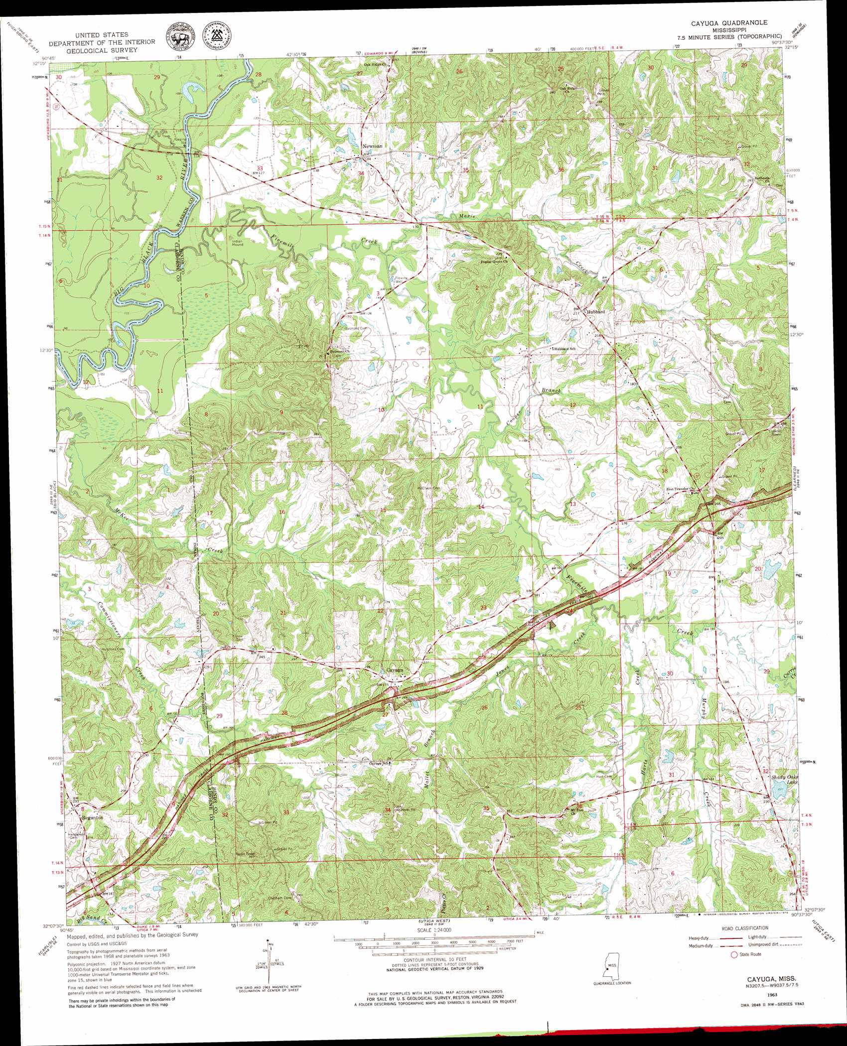
Cayuga Topo Map Mississippi
To zoom in, hover over the map of Cayuga
USGS Topo Quad 32090b6 - 1:24,000 scale
| Topo Map Name: | Cayuga |
| USGS Topo Quad ID: | 32090b6 |
| Print Size: | ca. 21 1/4" wide x 27" high |
| Southeast Coordinates: | 32.125° N latitude / 90.625° W longitude |
| Map Center Coordinates: | 32.1875° N latitude / 90.6875° W longitude |
| U.S. State: | MS |
| Filename: | o32090b6.jpg |
| Download Map JPG Image: | Cayuga topo map 1:24,000 scale |
| Map Type: | Topographic |
| Topo Series: | 7.5´ |
| Map Scale: | 1:24,000 |
| Source of Map Images: | United States Geological Survey (USGS) |
| Alternate Map Versions: |
Cayuga MS 1963, updated 1964 Download PDF Buy paper map Cayuga MS 1963, updated 1979 Download PDF Buy paper map Cayuga MS 1963, updated 1979 Download PDF Buy paper map Cayuga MS 2012 Download PDF Buy paper map Cayuga MS 2015 Download PDF Buy paper map |
1:24,000 Topo Quads surrounding Cayuga
Long Lake |
Redwood |
Oak Ridge |
Queens Hill Lake |
Brownsville |
Vicksburg West |
Vicksburg East |
Bovina |
Edwards |
Raymond |
Yokena |
Big Black |
Cayuga |
Learned |
Terry Nw |
Willows |
Carlisle |
Utica West |
Utica East |
Dabney Crossroads |
Port Gibson |
Hermanville |
Dentville Nw |
Dentville |
Gallman |
> Back to 32090a1 at 1:100,000 scale
> Back to 32090a1 at 1:250,000 scale
> Back to U.S. Topo Maps home
Cayuga topo map: Gazetteer
Cayuga: Crossings
Baldwins Ferry (historical) elevation 28m 91′Cayuga: Dams
Barlows Pond Dam elevation 78m 255′Barnes Lake Dam elevation 46m 150′
Hubbard Pond Dam elevation 70m 229′
Mims Lake Dam elevation 41m 134′
Shady Oaks Lake Dam elevation 71m 232′
Cayuga: Lakes
Five Mile Lake elevation 29m 95′Cayuga: Populated Places
Cayuga elevation 81m 265′Hubbard elevation 66m 216′
Newman elevation 57m 187′
Reganton elevation 72m 236′
Cayuga: Reservoirs
Shady Oaks Lake elevation 65m 213′Cayuga: Streams
Cooper Branch elevation 40m 131′Currie Creek elevation 51m 167′
Fivemile Creek elevation 27m 88′
Harts Creek elevation 49m 160′
Jones Creek elevation 46m 150′
Mallet Branch elevation 61m 200′
Maxie Creek elevation 34m 111′
Murphy Creek elevation 46m 150′
Neil Branch elevation 42m 137′
Cayuga digital topo map on disk
Buy this Cayuga topo map showing relief, roads, GPS coordinates and other geographical features, as a high-resolution digital map file on DVD: