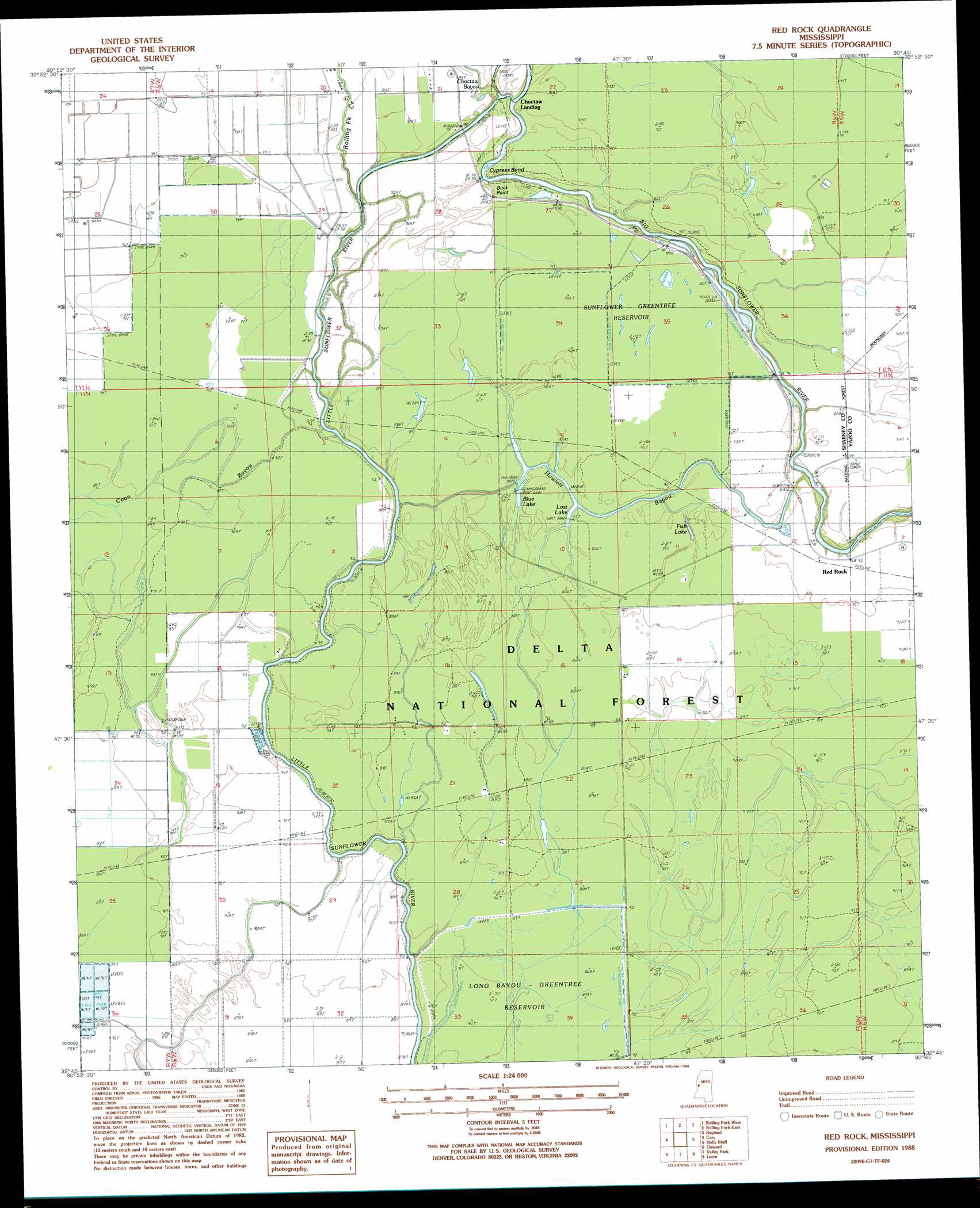
Red Rock Topo Map Mississippi
To zoom in, hover over the map of Red Rock
USGS Topo Quad 32090g7 - 1:24,000 scale
| Topo Map Name: | Red Rock |
| USGS Topo Quad ID: | 32090g7 |
| Print Size: | ca. 21 1/4" wide x 27" high |
| Southeast Coordinates: | 32.75° N latitude / 90.75° W longitude |
| Map Center Coordinates: | 32.8125° N latitude / 90.8125° W longitude |
| U.S. State: | MS |
| Filename: | o32090g7.jpg |
| Download Map JPG Image: | Red Rock topo map 1:24,000 scale |
| Map Type: | Topographic |
| Topo Series: | 7.5´ |
| Map Scale: | 1:24,000 |
| Source of Map Images: | United States Geological Survey (USGS) |
| Alternate Map Versions: |
Red Rock MS 1988, updated 1988 Download PDF Buy paper map Red Rock MS 2000, updated 2002 Download PDF Buy paper map Red Rock MS 2012 Download PDF Buy paper map Red Rock MS 2015 Download PDF Buy paper map |
| FStopo: | US Forest Service topo Red Rock is available: Download FStopo PDF Download FStopo TIF |
1:24,000 Topo Quads surrounding Red Rock
Glen Allan |
Percy |
Delta City |
Richey |
Midnight |
Mayersville |
Rolling Fork West |
Rolling Fork East |
Bayland |
Louise |
Whiting Bayou |
Cary |
Red Rock |
Holly Bluff |
Bayland Se |
Fitler |
Onward |
Valley Park |
Lucre |
Satartia |
Eagle Bend |
Cane Bayou |
Floweree |
Eldorado |
Phoenix |
> Back to 32090e1 at 1:100,000 scale
> Back to 32090a1 at 1:250,000 scale
> Back to U.S. Topo Maps home
Red Rock topo map: Gazetteer
Red Rock: Bends
Cypress Bend elevation 24m 78′Red Rock: Capes
Buck Point elevation 28m 91′Red Rock: Forests
Delta National Forest elevation 28m 91′Red Rock: Lakes
Fish Lake elevation 25m 82′Lost Lake elevation 26m 85′
Red Rock: Parks
Blue Lake Recreation Area elevation 28m 91′Sunflower Waterfowl Project elevation 26m 85′
Red Rock: Populated Places
Choctaw Landing elevation 27m 88′Red Rock: Reservoirs
Long Bayou-Greentree Reservoir elevation 27m 88′Sunflower-Greentree Reservoir elevation 26m 85′
Red Rock: Streams
Choctaw Bayou elevation 26m 85′Howlett Bayou elevation 22m 72′
Rolling Fork Creek elevation 22m 72′
Red Rock digital topo map on disk
Buy this Red Rock topo map showing relief, roads, GPS coordinates and other geographical features, as a high-resolution digital map file on DVD: