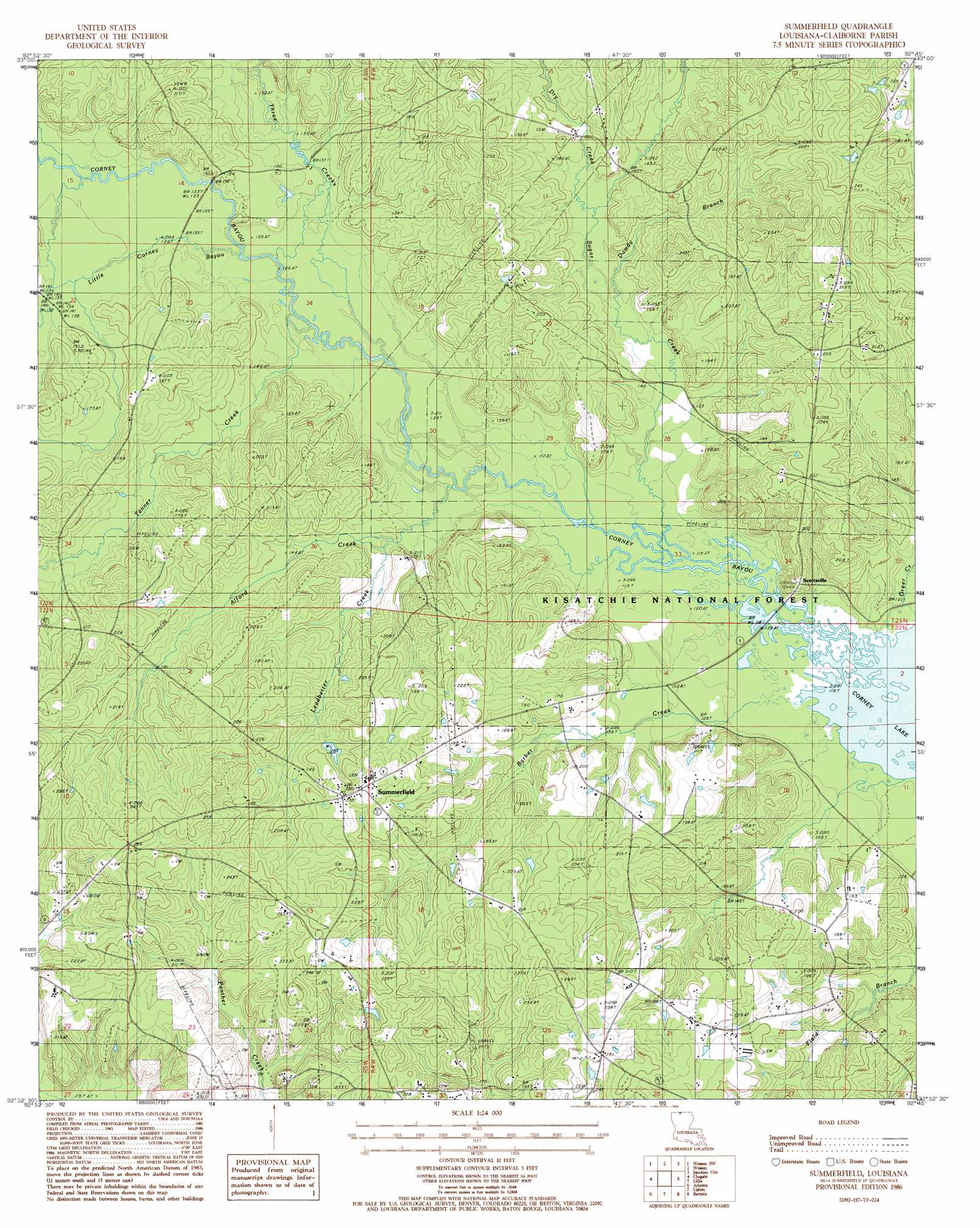
Summerfield Topo Map Louisiana
To zoom in, hover over the map of Summerfield
USGS Topo Quad 32092h7 - 1:24,000 scale
| Topo Map Name: | Summerfield |
| USGS Topo Quad ID: | 32092h7 |
| Print Size: | ca. 21 1/4" wide x 27" high |
| Southeast Coordinates: | 32.875° N latitude / 92.75° W longitude |
| Map Center Coordinates: | 32.9375° N latitude / 92.8125° W longitude |
| U.S. State: | LA |
| Filename: | o32092h7.jpg |
| Download Map JPG Image: | Summerfield topo map 1:24,000 scale |
| Map Type: | Topographic |
| Topo Series: | 7.5´ |
| Map Scale: | 1:24,000 |
| Source of Map Images: | United States Geological Survey (USGS) |
| Alternate Map Versions: |
Summerfield LA 1986, updated 1986 Download PDF Buy paper map Summerfield LA 2003, updated 2005 Download PDF Buy paper map Summerfield LA 2012 Download PDF Buy paper map Summerfield LA 2015 Download PDF Buy paper map |
| FStopo: | US Forest Service topo Summerfield is available: Download FStopo PDF Download FStopo TIF |
1:24,000 Topo Quads surrounding Summerfield
Spotville |
Marysville |
Newell |
El Dorado West |
El Dorado East |
Emerson Se |
Wesson Sw |
Wesson |
Junction City |
Lockhart |
Haynesville East |
Colquitt |
Summerfield |
Lillie |
Spearsville |
Homer |
Arizona |
Lisbon |
Bernice |
Shiloh |
Athens |
Marsalis |
Lake Foursome |
Dubach |
Cedarton |
> Back to 32092e1 at 1:100,000 scale
> Back to 32092a1 at 1:250,000 scale
> Back to U.S. Topo Maps home
Summerfield topo map: Gazetteer
Summerfield: Dams
Corney Dam elevation 57m 187′Summerfield: Oilfields
Lisbon Gas Field elevation 61m 200′Southwest Lillie Oil Field elevation 65m 213′
Summerfield: Populated Places
Hebron elevation 74m 242′Scottsville elevation 54m 177′
Summerfield elevation 70m 229′
Summerfield: Post Offices
Summerfield Post Office elevation 70m 229′Summerfield: Reservoirs
Corney Lake elevation 57m 187′Summerfield: Streams
Alford Creek elevation 39m 127′Barber Creek elevation 36m 118′
Dowdy Branch elevation 37m 121′
Dry Creek elevation 40m 131′
Dry Creek elevation 40m 131′
Greer Creek elevation 36m 118′
Leadbetter Creek elevation 36m 118′
Little Corney Creek elevation 36m 118′
Sugar Creek elevation 35m 114′
Sugar Creek elevation 35m 114′
Tanner Creek elevation 37m 121′
Three Creeks elevation 36m 118′
Summerfield digital topo map on disk
Buy this Summerfield topo map showing relief, roads, GPS coordinates and other geographical features, as a high-resolution digital map file on DVD: