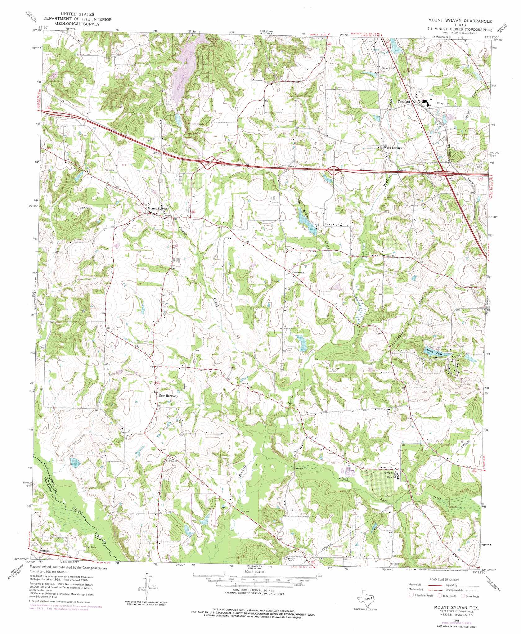
Mount Sylvan Topo Map Texas
To zoom in, hover over the map of Mount Sylvan
USGS Topo Quad 32095d4 - 1:24,000 scale
| Topo Map Name: | Mount Sylvan |
| USGS Topo Quad ID: | 32095d4 |
| Print Size: | ca. 21 1/4" wide x 27" high |
| Southeast Coordinates: | 32.375° N latitude / 95.375° W longitude |
| Map Center Coordinates: | 32.4375° N latitude / 95.4375° W longitude |
| U.S. State: | TX |
| Filename: | o32095d4.jpg |
| Download Map JPG Image: | Mount Sylvan topo map 1:24,000 scale |
| Map Type: | Topographic |
| Topo Series: | 7.5´ |
| Map Scale: | 1:24,000 |
| Source of Map Images: | United States Geological Survey (USGS) |
| Alternate Map Versions: |
Mount Sylvan TX 1966, updated 1969 Download PDF Buy paper map Mount Sylvan TX 1966, updated 1975 Download PDF Buy paper map Mount Sylvan TX 2010 Download PDF Buy paper map Mount Sylvan TX 2012 Download PDF Buy paper map Mount Sylvan TX 2016 Download PDF Buy paper map |
1:24,000 Topo Quads surrounding Mount Sylvan
Grand Saline |
Golden |
Mineola |
Hainesville |
Shady Grove |
Van |
Van Lake |
Lindale |
Crow |
Hawkins |
Ben Wheeler |
Carroll |
Mount Sylvan |
Tyler North |
Winona |
Murchinson East |
Brownsboro |
Chandler |
Tyler South |
Bascom |
Leagueville |
Moore Station |
Saline Bay |
Bullard |
Troup West |
> Back to 32095a1 at 1:100,000 scale
> Back to 32094a1 at 1:250,000 scale
> Back to U.S. Topo Maps home
Mount Sylvan topo map: Gazetteer
Mount Sylvan: Airports
Hide-A-Way Lake Airport elevation 172m 564′Mount Sylvan: Dams
Hide-A-Way Lake Number 1 Dam elevation 132m 433′House Lake Dam elevation 131m 429′
Jones Lake Dam elevation 126m 413′
Powell Lake Dam elevation 124m 406′
Swan Lake Dam elevation 155m 508′
Mount Sylvan: Populated Places
Hideaway elevation 137m 449′Hide-A-Way Lake elevation 138m 452′
Mount Sylvan elevation 164m 538′
New Harmony elevation 150m 492′
Redland elevation 131m 429′
Thedford elevation 156m 511′
Wood Springs elevation 142m 465′
Mount Sylvan: Reservoirs
Hide-A-Way Lake elevation 126m 413′Hide-A-Way Lake Number 1 elevation 132m 433′
Hide-A-Way Lake Number Two elevation 121m 396′
House Lake elevation 131m 429′
Jones Lake elevation 126m 413′
Powell Pond elevation 124m 406′
Swan Lake elevation 149m 488′
Mount Sylvan: Streams
Black Fork Creek elevation 113m 370′Caney Creek elevation 117m 383′
Chinquapin Creek elevation 118m 387′
Long Brake Creek elevation 123m 403′
Mount Sylvan digital topo map on disk
Buy this Mount Sylvan topo map showing relief, roads, GPS coordinates and other geographical features, as a high-resolution digital map file on DVD: