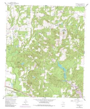
Hainesville Topo Map Texas
To zoom in, hover over the map of Hainesville
USGS Topo Quad 32095f3 - 1:24,000 scale
| Topo Map Name: | Hainesville |
| USGS Topo Quad ID: | 32095f3 |
| Print Size: | ca. 21 1/4" wide x 27" high |
| Southeast Coordinates: | 32.625° N latitude / 95.25° W longitude |
| Map Center Coordinates: | 32.6875° N latitude / 95.3125° W longitude |
| U.S. State: | TX |
| Filename: | o32095f3.jpg |
| Download Map JPG Image: | Hainesville topo map 1:24,000 scale |
| Map Type: | Topographic |
| Topo Series: | 7.5´ |
| Map Scale: | 1:24,000 |
| Source of Map Images: | United States Geological Survey (USGS) |
| Alternate Map Versions: |
Hainesville TX 1960, updated 1962 Download PDF Buy paper map Hainesville TX 1960, updated 1982 Download PDF Buy paper map Hainesville TX 2010 Download PDF Buy paper map Hainesville TX 2012 Download PDF Buy paper map Hainesville TX 2016 Download PDF Buy paper map |
1:24,000 Topo Quads surrounding Hainesville
> Back to 32095e1 at 1:100,000 scale
> Back to 32094a1 at 1:250,000 scale
> Back to U.S. Topo Maps home
Hainesville topo map: Gazetteer
Hainesville: Dams
Bobo Lake Dam elevation 131m 429′Camp Lake Dam elevation 113m 370′
Indian Mound Dam elevation 124m 406′
Lake O the Woods Dam elevation 112m 367′
Lower West Lake Dam elevation 106m 347′
Redland Acres Dam elevation 126m 413′
Upper West Lake Dam elevation 113m 370′
Hainesville: Lakes
Haines Lake elevation 93m 305′Wisenbaker Lake elevation 108m 354′
Hainesville: Oilfields
Dupree Oil Field elevation 132m 433′Shirley Barbara Oil Field elevation 158m 518′
Hainesville: Parks
Page Park elevation 139m 456′Hainesville: Populated Places
Fouke elevation 143m 469′Hainesville elevation 116m 380′
Pine Mills elevation 141m 462′
Hainesville: Reservoirs
Bobo Lake elevation 131m 429′Brooks Lake elevation 126m 413′
Camp Lake elevation 113m 370′
Dobbs Lake elevation 134m 439′
Indian Mound Lake elevation 124m 406′
Lake O the Woods elevation 112m 367′
Lower West Lake elevation 106m 347′
Puckett Lake elevation 108m 354′
Redland Acres Lake elevation 126m 413′
Shipps Lake elevation 131m 429′
Upper West Lake elevation 113m 370′
West Lakes elevation 107m 351′
Hainesville: Streams
Black Creek elevation 92m 301′Clear Branch elevation 104m 341′
Cowan Branch elevation 105m 344′
George White Branch elevation 104m 341′
Haines Creek elevation 94m 308′
Highland Pond Branch elevation 107m 351′
Jayco Branch elevation 111m 364′
Jones Branch elevation 107m 351′
Lacey Branch elevation 91m 298′
Mill Race elevation 93m 305′
Norman Branch elevation 121m 396′
Patton Creek elevation 95m 311′
Poley Branch elevation 115m 377′
Red Branch elevation 114m 374′
Red Branch elevation 110m 360′
Rock Falls Creek elevation 91m 298′
Stagner Branch elevation 120m 393′
Hainesville digital topo map on disk
Buy this Hainesville topo map showing relief, roads, GPS coordinates and other geographical features, as a high-resolution digital map file on DVD:


