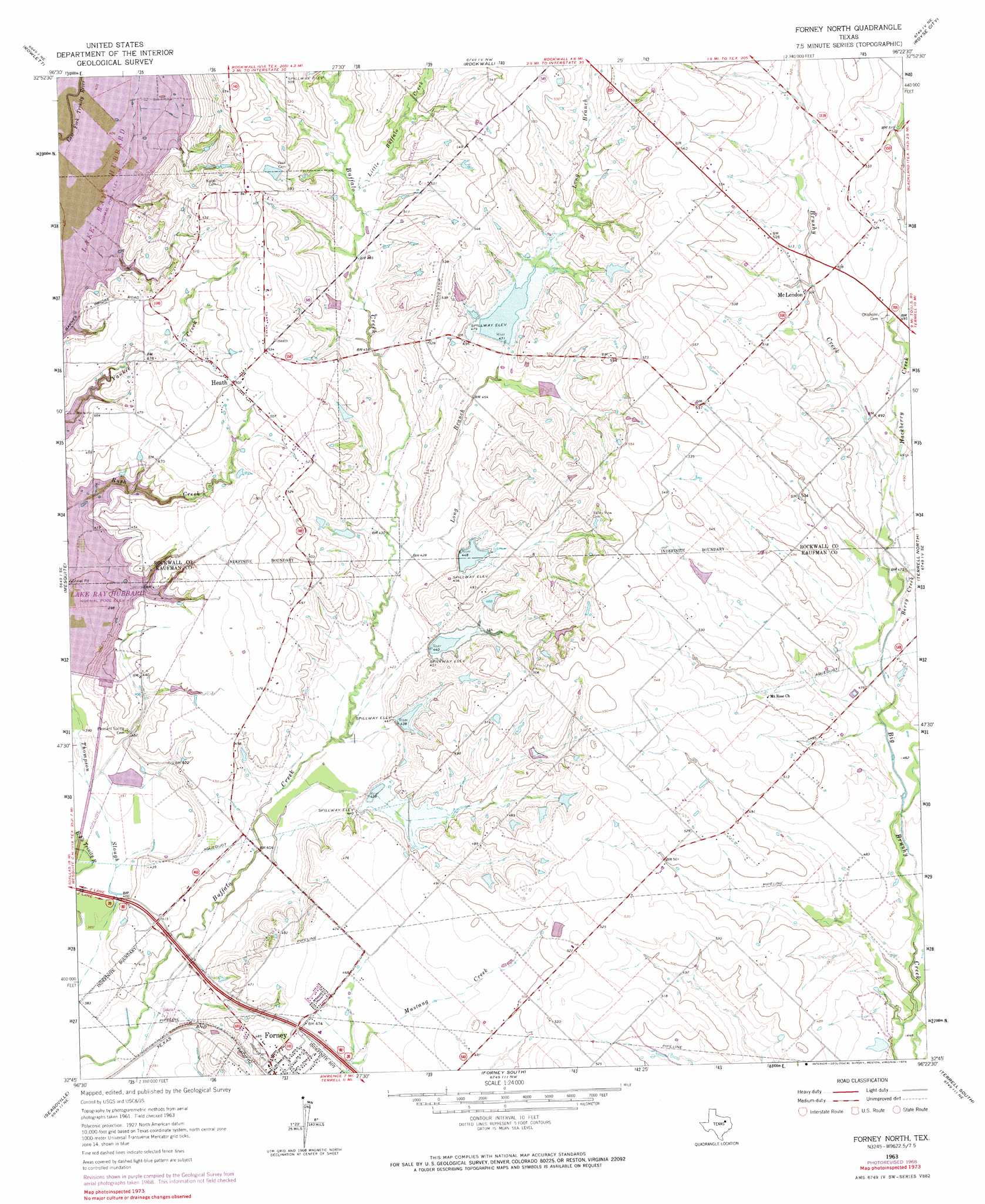
Forney North Topo Map Texas
To zoom in, hover over the map of Forney North
USGS Topo Quad 32096g4 - 1:24,000 scale
| Topo Map Name: | Forney North |
| USGS Topo Quad ID: | 32096g4 |
| Print Size: | ca. 21 1/4" wide x 27" high |
| Southeast Coordinates: | 32.75° N latitude / 96.375° W longitude |
| Map Center Coordinates: | 32.8125° N latitude / 96.4375° W longitude |
| U.S. State: | TX |
| Filename: | o32096g4.jpg |
| Download Map JPG Image: | Forney North topo map 1:24,000 scale |
| Map Type: | Topographic |
| Topo Series: | 7.5´ |
| Map Scale: | 1:24,000 |
| Source of Map Images: | United States Geological Survey (USGS) |
| Alternate Map Versions: |
Forney North TX 1963, updated 1966 Download PDF Buy paper map Forney North TX 1963, updated 1969 Download PDF Buy paper map Forney North TX 1963, updated 1974 Download PDF Buy paper map Forney North TX 1995, updated 2002 Download PDF Buy paper map Forney North TX 2011 Download PDF Buy paper map Forney North TX 2012 Download PDF Buy paper map Forney North TX 2016 Download PDF Buy paper map |
1:24,000 Topo Quads surrounding Forney North
Plano |
Wylie |
Lavon |
Josephine |
Greenville Sw |
Garland |
Rowlett |
Rockwall |
Royse City |
Quinlan |
White Rock Lake |
Mesquite |
Forney North |
Terrell North |
Poetry |
Hutchins |
Seagoville |
Forney South |
Terrell South |
Elmo |
Ferris |
India |
Scurry |
Kaufman |
Ola |
> Back to 32096e1 at 1:100,000 scale
> Back to 32096a1 at 1:250,000 scale
> Back to U.S. Topo Maps home
Forney North topo map: Gazetteer
Forney North: Airports
Klutts Field elevation 149m 488′Lagrone Ranch Airport elevation 173m 567′
Forney North: Dams
Soil Conservation Service Site 10 Dam elevation 129m 423′Soil Conservation Service Site 14a Dam elevation 155m 508′
Soil Conservation Service Site 15 Dam elevation 146m 479′
Soil Conservation Service Site 18 Dam elevation 146m 479′
Soil Conservation Service Site 19 Dam elevation 140m 459′
Soil Conservation Service Site 21a Dam elevation 144m 472′
Soil Conservation Service Site 6 Dam elevation 140m 459′
Soil Conservation Service Site 7 Dam elevation 142m 465′
Soil Conservation Service Site 7 Dam elevation 161m 528′
Soil Conservation Service Site 8 Dam elevation 154m 505′
Soil Conservation Service Site 8 Dam elevation 137m 449′
Soil Conservation Service Site 9 Dam elevation 137m 449′
Soil Conservation Service Site 9a Dam elevation 134m 439′
University Park Lake Dam elevation 148m 485′
Forney North: Guts
Thompson Slough elevation 120m 393′Forney North: Populated Places
Heath elevation 153m 501′McLendon elevation 153m 501′
McLendon-Chisholm elevation 154m 505′
Forney North: Reservoirs
Ray Hubbard Lake elevation 118m 387′Soil Conservation Service Site 10 Reservoir elevation 129m 423′
Soil Conservation Service Site 14a Reservoir elevation 155m 508′
Soil Conservation Service Site 15 Reservoir elevation 146m 479′
Soil Conservation Service Site 18 Reservoir elevation 146m 479′
Soil Conservation Service Site 19 Reservoir elevation 140m 459′
Soil Conservation Service Site 21a Reservoir elevation 144m 472′
Soil Conservation Service Site 6 Reservoir elevation 140m 459′
Soil Conservation Service Site 7 Reservoir elevation 161m 528′
Soil Conservation Service Site 7 Reservoir elevation 142m 465′
Soil Conservation Service Site 8 Reservoir elevation 154m 505′
Soil Conservation Service Site 8 Reservoir elevation 137m 449′
Soil Conservation Service Site 9 Reservoir elevation 137m 449′
Soil Conservation Service Site 9a Reservoir elevation 134m 439′
University Park Lake elevation 148m 485′
Forney North: Streams
Berry Creek elevation 144m 472′Brockway Branch elevation 147m 482′
Brushy Creek elevation 143m 469′
Hackberry Creek elevation 144m 472′
Little Buffalo Creek elevation 144m 472′
Long Branch elevation 128m 419′
Forney North digital topo map on disk
Buy this Forney North topo map showing relief, roads, GPS coordinates and other geographical features, as a high-resolution digital map file on DVD: