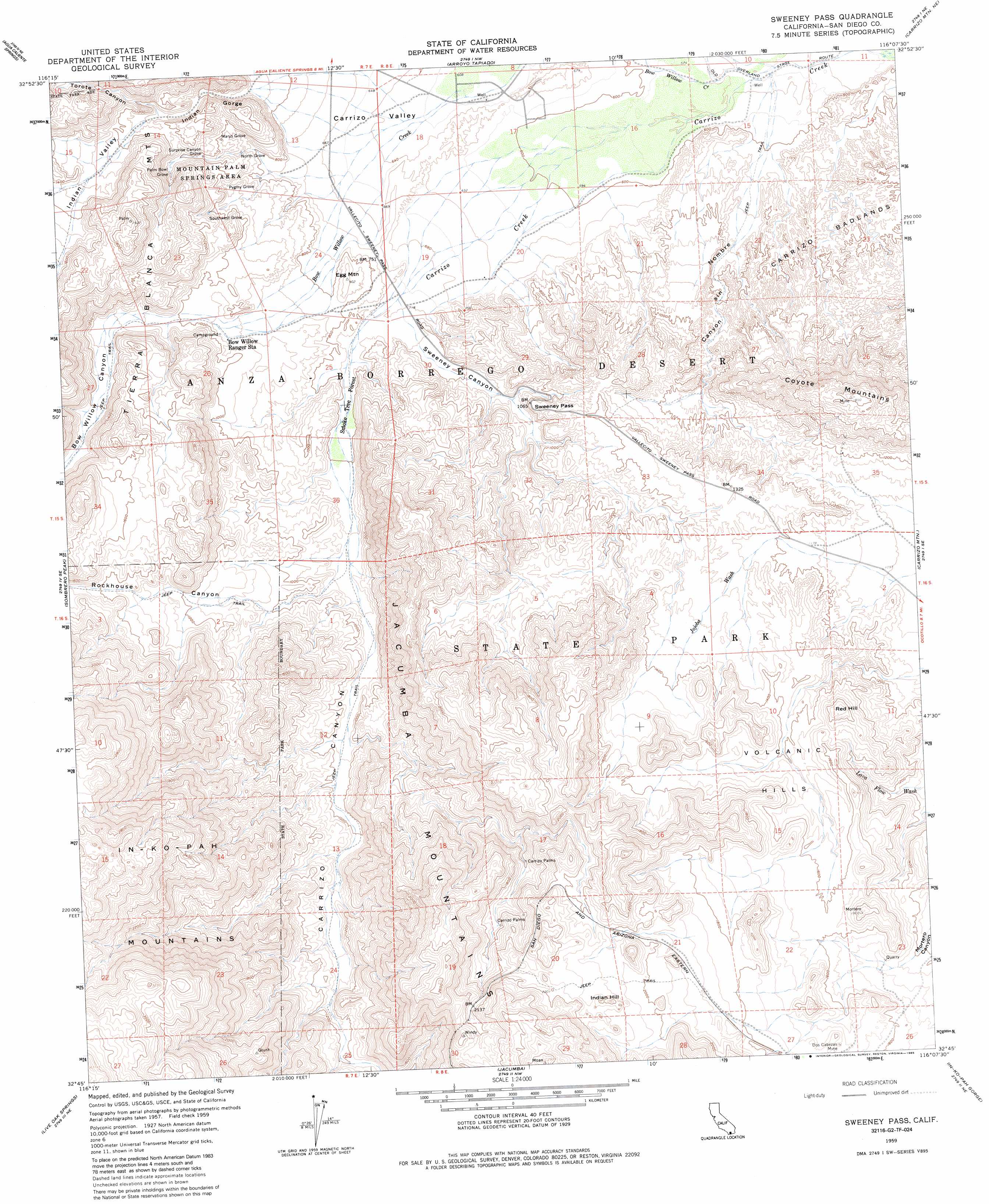
Sweeney Pass Topo Map California
To zoom in, hover over the map of Sweeney Pass
USGS Topo Quad 32116g2 - 1:24,000 scale
| Topo Map Name: | Sweeney Pass |
| USGS Topo Quad ID: | 32116g2 |
| Print Size: | ca. 21 1/4" wide x 27" high |
| Southeast Coordinates: | 32.75° N latitude / 116.125° W longitude |
| Map Center Coordinates: | 32.8125° N latitude / 116.1875° W longitude |
| U.S. State: | CA |
| Filename: | o32116g2.jpg |
| Download Map JPG Image: | Sweeney Pass topo map 1:24,000 scale |
| Map Type: | Topographic |
| Topo Series: | 7.5´ |
| Map Scale: | 1:24,000 |
| Source of Map Images: | United States Geological Survey (USGS) |
| Alternate Map Versions: |
Sweeney Pass CA 1959, updated 1960 Download PDF Buy paper map Sweeney Pass CA 1959, updated 1965 Download PDF Buy paper map Sweeney Pass CA 1959, updated 1985 Download PDF Buy paper map Sweeney Pass CA 1959, updated 1985 Download PDF Buy paper map Sweeney Pass CA 1997, updated 2003 Download PDF Buy paper map Sweeney Pass CA 2012 Download PDF Buy paper map Sweeney Pass CA 2015 Download PDF Buy paper map |
1:24,000 Topo Quads surrounding Sweeney Pass
Earthquake Valley |
Whale Peak |
Harper Canyon |
Borrego Mountain Se |
Harpers Well |
Monument Peak |
Agua Caliente Springs |
Arroyo Tapiado |
Carrizo Mountain Ne |
Plaster City Nw |
Mount Laguna |
Sombrero Peak |
Sweeney Pass |
Carrizo Mountain |
Painted Gorge |
Cameron Corners |
Live Oak Springs |
Jacumba |
In-Ko-Pah Gorge |
Coyote Wells |
Campo |
Tierra Del Sol |
> Back to 32116e1 at 1:100,000 scale
> Back to 32116a1 at 1:250,000 scale
> Back to U.S. Topo Maps home
Sweeney Pass topo map: Gazetteer
Sweeney Pass: Areas
Mountain Palm Springs Area elevation 328m 1076′Sweeney Pass: Gaps
Sweeney Pass elevation 298m 977′Sweeney Pass: Mines
Dos Cabezas Mine elevation 523m 1715′Sweeney Pass: Ranges
Volcanic Hills elevation 448m 1469′Sweeney Pass: Springs
Mountain Palm Springs elevation 311m 1020′Sweeney Pass: Streams
Bow Willow Creek elevation 166m 544′Jojoba Wash elevation 329m 1079′
Lava Flow Wash elevation 343m 1125′
Vallecito Wash elevation 165m 541′
Sweeney Pass: Summits
Egg Mountain elevation 271m 889′Indian Hill elevation 686m 2250′
Red Hill elevation 505m 1656′
Sweeney Pass: Valleys
Bow Willow Canyon elevation 290m 951′Canyon Nombre elevation 173m 567′
Carrizo Canyon elevation 213m 698′
Carrizo Valley elevation 190m 623′
Indian Gorge elevation 281m 921′
Indian Valley elevation 351m 1151′
Rockhouse Canyon elevation 265m 869′
Sweeney Canyon elevation 218m 715′
Torote Canyon elevation 347m 1138′
Sweeney Pass: Woods
Marys Grove elevation 299m 980′North Grove elevation 271m 889′
Palm Bowl Grove elevation 317m 1040′
Pygmy Grove elevation 277m 908′
Southwest Grove elevation 337m 1105′
Surprise Canyon Grove elevation 324m 1062′
Sweeney Pass digital topo map on disk
Buy this Sweeney Pass topo map showing relief, roads, GPS coordinates and other geographical features, as a high-resolution digital map file on DVD: