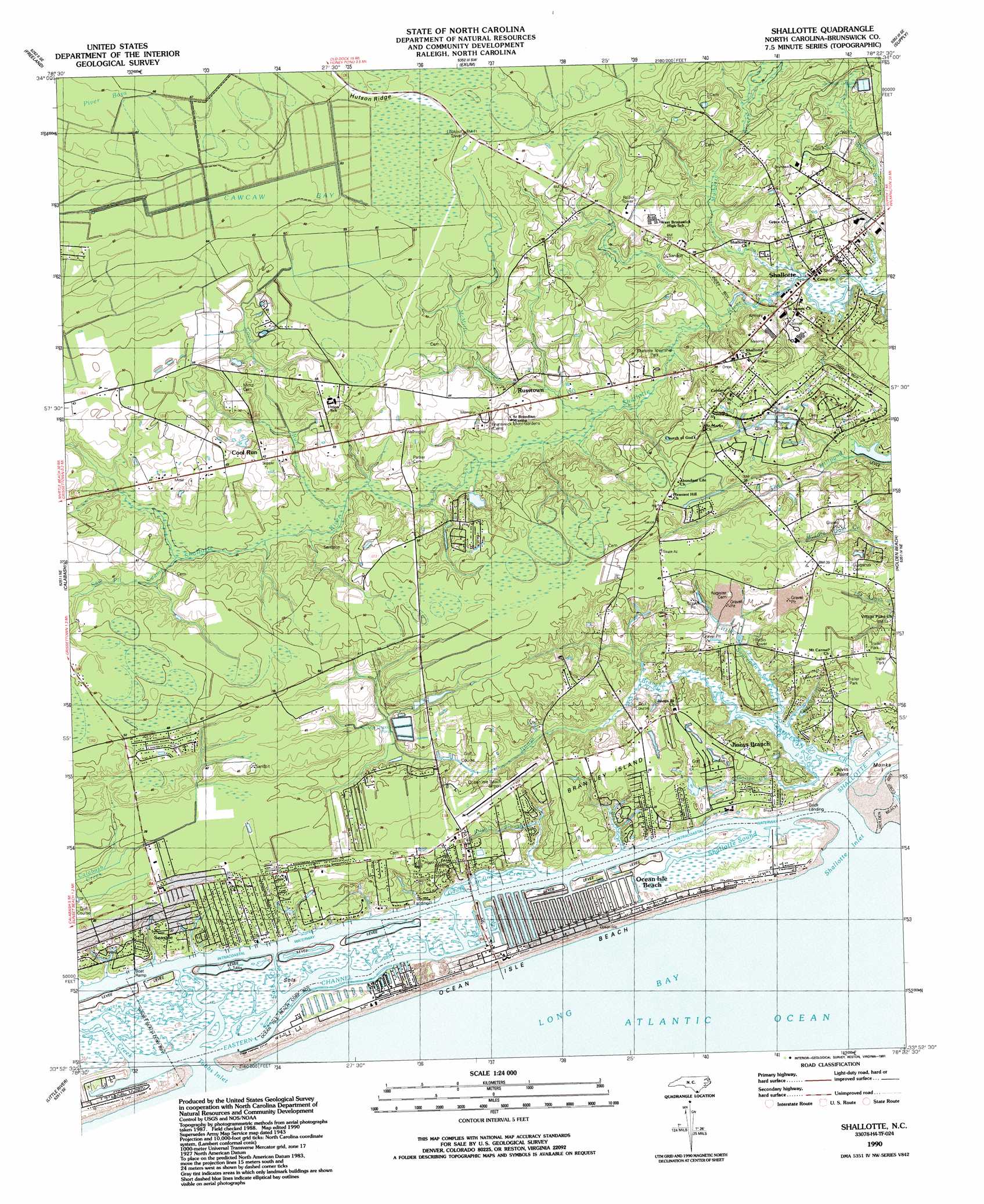
Shallotte Topo Map North Carolina
To zoom in, hover over the map of Shallotte
USGS Topo Quad 33078h4 - 1:24,000 scale
| Topo Map Name: | Shallotte |
| USGS Topo Quad ID: | 33078h4 |
| Print Size: | ca. 21 1/4" wide x 27" high |
| Southeast Coordinates: | 33.875° N latitude / 78.375° W longitude |
| Map Center Coordinates: | 33.9375° N latitude / 78.4375° W longitude |
| U.S. State: | NC |
| Filename: | o33078h4.jpg |
| Download Map JPG Image: | Shallotte topo map 1:24,000 scale |
| Map Type: | Topographic |
| Topo Series: | 7.5´ |
| Map Scale: | 1:24,000 |
| Source of Map Images: | United States Geological Survey (USGS) |
| Alternate Map Versions: |
Shallotte NC 1943, updated 1962 Download PDF Buy paper map Shallotte NC 1990, updated 1991 Download PDF Buy paper map Shallotte NC 2010 Download PDF Buy paper map Shallotte NC 2013 Download PDF Buy paper map Shallotte NC 2016 Download PDF Buy paper map |
1:24,000 Topo Quads surrounding Shallotte
Nakina |
Old Dock |
Juniper Creek |
Honey Island |
Lewis Swamp |
Pireway |
Freeland |
Exum |
Supply |
Bolivia |
Longs |
Calabash |
Shallotte |
Holden Beach |
Lockwoods Folly |
Wampee |
Little River |
|||
> Back to 33078e1 at 1:100,000 scale
> Back to 33078a1 at 1:250,000 scale
> Back to U.S. Topo Maps home
Shallotte topo map: Gazetteer
Shallotte: Airports
Ocean Isle Airport elevation 10m 32′Ocean Isle Beach Airport elevation 9m 29′
Shallotte: Bays
Shallotte Sound elevation 0m 0′Shallotte: Beaches
Ocean Isle Beach elevation 1m 3′Shallotte: Capes
Calvin Point elevation 5m 16′Shallotte: Channels
Eastern Channel elevation 26m 85′Shallotte Inlet elevation 1m 3′
Shallotte: Guts
Apricot Creek elevation 3m 9′Clam Creek elevation 1m 3′
Cooter Creek elevation -9m -30′
Gause Landing Creek elevation 1m 3′
Gold Mine Creek elevation 1m 3′
Horse Ford Creek elevation 1m 3′
Jinks Creek elevation 0m 0′
Needham Hole Creek elevation 0m 0′
Sols Creek elevation -7m -23′
Spring Branch elevation 1m 3′
Still Creek elevation -17m -56′
Tubbs Inlet elevation 0m 0′
Shallotte: Islands
Brantley Island elevation 9m 29′Monks Island elevation 2m 6′
Sols Island elevation 1m 3′
Shallotte: Parks
Shallotte Township Park elevation 4m 13′Shallotte: Populated Places
Brick Landing elevation 1m 3′Brick Landing Plantation elevation 1m 3′
Cool Run elevation 12m 39′
Jinnys Branch elevation 8m 26′
Ocean Isle Beach elevation 1m 3′
Russtown elevation 7m 22′
Sea Trail Plantation elevation 7m 22′
Seaside elevation 4m 13′
Shallotte elevation 5m 16′
Summerhomes Mobile Home Park elevation 15m 49′
Shallotte: Post Offices
Ocean Isle Beach Post Office (historical) elevation 1m 3′Shallotte: Ridges
Hutson Ridge elevation 20m 65′Shallotte: Streams
Big Gut Slough elevation 1m 3′Cool Run elevation 5m 16′
Goose Creek elevation 1m 3′
Jinnys Branch elevation -3m -10′
Kilbart Slough elevation 1m 3′
Little Saucepan Creek elevation 0m 0′
Lookout Branch elevation 1m 3′
McMilly Swamp elevation 2m 6′
Mulberry Branch elevation 1m 3′
Old Mill Creek elevation 1m 3′
Saucepan Creek elevation 0m 0′
Saw Pit Swamp elevation 7m 22′
Shallotte River elevation 0m 0′
Woodward Branch elevation 1m 3′
Shallotte: Swamps
Cawcaw Bay elevation 17m 55′Head o' Bay elevation 20m 65′
Piver Bays elevation 20m 65′
Shallotte digital topo map on disk
Buy this Shallotte topo map showing relief, roads, GPS coordinates and other geographical features, as a high-resolution digital map file on DVD:
South Carolina, Western North Carolina & Northeastern Georgia
Buy digital topo maps: South Carolina, Western North Carolina & Northeastern Georgia