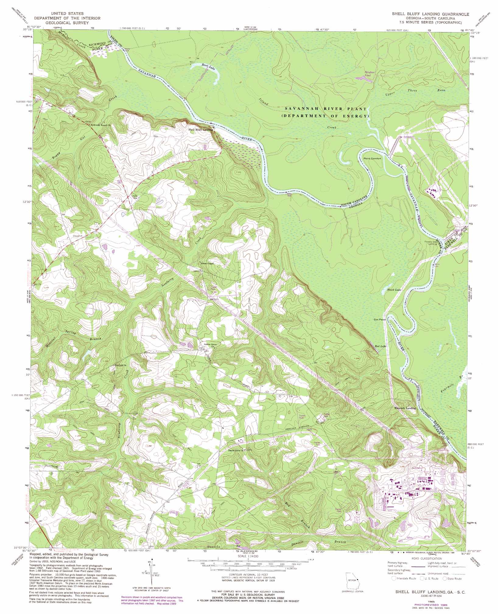
Shell Bluff Landing Topo Map Georgia
To zoom in, hover over the map of Shell Bluff Landing
USGS Topo Quad 33081b7 - 1:24,000 scale
| Topo Map Name: | Shell Bluff Landing |
| USGS Topo Quad ID: | 33081b7 |
| Print Size: | ca. 21 1/4" wide x 27" high |
| Southeast Coordinates: | 33.125° N latitude / 81.75° W longitude |
| Map Center Coordinates: | 33.1875° N latitude / 81.8125° W longitude |
| U.S. States: | GA, SC |
| Filename: | o33081b7.jpg |
| Download Map JPG Image: | Shell Bluff Landing topo map 1:24,000 scale |
| Map Type: | Topographic |
| Topo Series: | 7.5´ |
| Map Scale: | 1:24,000 |
| Source of Map Images: | United States Geological Survey (USGS) |
| Alternate Map Versions: |
Shell Bluff Landing GA 1965, updated 1968 Download PDF Buy paper map Shell Bluff Landing GA 1965, updated 1981 Download PDF Buy paper map Shell Bluff Landing GA 1965, updated 1989 Download PDF Buy paper map Shell Bluff Landing GA 2011 Download PDF Buy paper map Shell Bluff Landing GA 2014 Download PDF Buy paper map |
| FStopo: | US Forest Service topo Shell Bluff Landing is available: Download FStopo PDF Download FStopo TIF |
1:24,000 Topo Quads surrounding Shell Bluff Landing
Augusta West |
Augusta East |
Hollow Creek |
New Ellenton |
Windsor |
Hephzibah |
Mechanic Hill |
Jackson |
New Ellenton Sw |
New Ellenton Se |
Storys Millpond |
Mcbean |
Shell Bluff Landing |
Girard Nw |
Girard Ne |
Waynesboro |
Idlewood |
Alexander |
Girard |
Millett |
Bellevue |
Perkins |
Sardis |
Hilltonia |
Burtons Ferry Landing |
> Back to 33081a1 at 1:100,000 scale
> Back to 33080a1 at 1:250,000 scale
> Back to U.S. Topo Maps home
Shell Bluff Landing topo map: Gazetteer
Shell Bluff Landing: Capes
Flowers Point elevation 27m 88′Point Comfort elevation 29m 95′
Shell Bluff Landing: Cliffs
Shell Bluff elevation 43m 141′Shell Bluff Landing: Crossings
Demaries Ferry (historical) elevation 27m 88′Demaries Ferry (historical) elevation 27m 88′
Dog Ferry (historical) elevation 26m 85′
Dog Ferry (historical) elevation 26m 85′
Shell Bluff Landing: Lakes
Bent Lake elevation 28m 91′Shell Bluff Landing: Populated Places
Ellenton (historical) elevation 28m 91′Hancock Landing elevation 28m 91′
Shell Bluff Landing elevation 30m 98′
Shell Bluff Landing: Reservoirs
Black Lake elevation 26m 85′Red Lake elevation 26m 85′
Skinface Pond elevation 32m 104′
Smiths Pond elevation 47m 154′
Shell Bluff Landing: Streams
Boggy Gut Creek elevation 27m 88′Island Creek elevation 26m 85′
McBean Creek elevation 27m 88′
Mineral Spring Branch elevation 35m 114′
Newberry Creek elevation 27m 88′
Red Branch elevation 36m 118′
Stewart Branch elevation 33m 108′
Upper Three Runs elevation 26m 85′
Shell Bluff Landing: Swamps
D'Antignac Swamp elevation 27m 88′Shell Bluff Landing digital topo map on disk
Buy this Shell Bluff Landing topo map showing relief, roads, GPS coordinates and other geographical features, as a high-resolution digital map file on DVD:
South Carolina, Western North Carolina & Northeastern Georgia
Buy digital topo maps: South Carolina, Western North Carolina & Northeastern Georgia