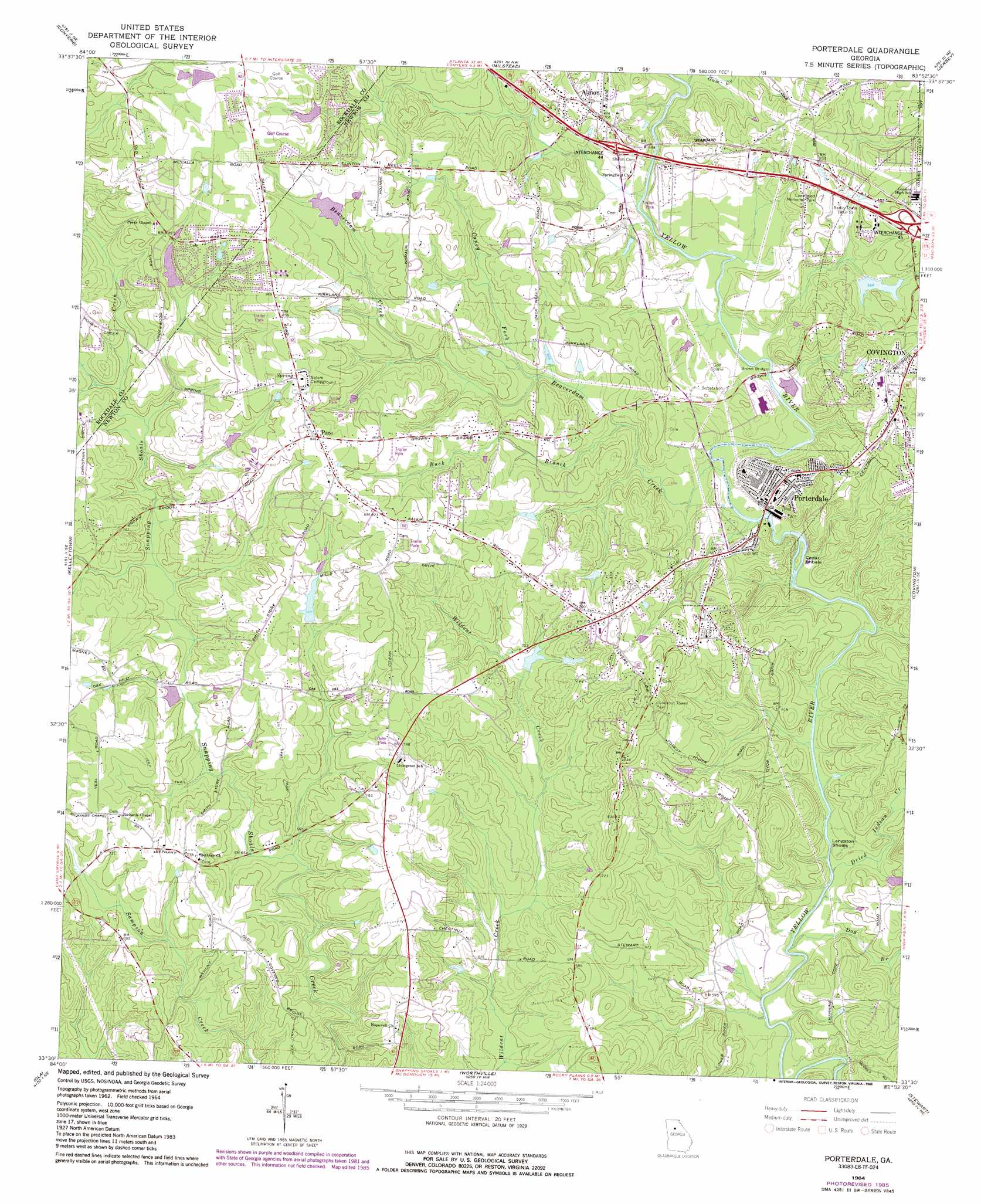
Porterdale Topo Map Georgia
To zoom in, hover over the map of Porterdale
USGS Topo Quad 33083e8 - 1:24,000 scale
| Topo Map Name: | Porterdale |
| USGS Topo Quad ID: | 33083e8 |
| Print Size: | ca. 21 1/4" wide x 27" high |
| Southeast Coordinates: | 33.5° N latitude / 83.875° W longitude |
| Map Center Coordinates: | 33.5625° N latitude / 83.9375° W longitude |
| U.S. State: | GA |
| Filename: | o33083e8.jpg |
| Download Map JPG Image: | Porterdale topo map 1:24,000 scale |
| Map Type: | Topographic |
| Topo Series: | 7.5´ |
| Map Scale: | 1:24,000 |
| Source of Map Images: | United States Geological Survey (USGS) |
| Alternate Map Versions: |
Porterdale GA 1964, updated 1966 Download PDF Buy paper map Porterdale GA 1964, updated 1976 Download PDF Buy paper map Porterdale GA 1964, updated 1985 Download PDF Buy paper map Porterdale GA 2011 Download PDF Buy paper map Porterdale GA 2014 Download PDF Buy paper map |
1:24,000 Topo Quads surrounding Porterdale
Stone Mountain |
Snellville |
Loganville |
Between |
Monroe |
Redan |
Conyers |
Milstead |
Jersey |
Social Circle |
Stockbridge |
Kelleytown |
Porterdale |
Covington |
Mansfield |
Mcdonough |
Ola |
Worthville |
Stewart |
Farrar |
Luella |
Locust Grove |
Jackson |
Lloyd Shoals Dam |
Monticello |
> Back to 33083e1 at 1:100,000 scale
> Back to 33082a1 at 1:250,000 scale
> Back to U.S. Topo Maps home
Porterdale topo map: Gazetteer
Porterdale: Airports
Flanigan Airport elevation 252m 826′Newton General Hospital Heliport elevation 232m 761′
Porterdale: Bars
Cedar Shoals elevation 172m 564′Langston Shoals elevation 165m 541′
Porterdale: Bridges
Brown Bridge elevation 195m 639′Porterdale: Crossings
Exit 44 elevation 213m 698′Exit 45 elevation 231m 757′
Porterdale: Dams
Bailey Lake Dam elevation 207m 679′Paradise Lake Dam elevation 225m 738′
Salem Lake Dam elevation 235m 770′
Turner Lake Dam elevation 204m 669′
Porterdale: Populated Places
Abide Awhile elevation 253m 830′Almon elevation 212m 695′
Beaver Creek elevation 225m 738′
Brandy Shoals elevation 232m 761′
Brown Bridge Square elevation 214m 702′
Buck Creek elevation 246m 807′
Country Acres Mobile Home Park elevation 233m 764′
Country Terrace elevation 244m 800′
Country View elevation 227m 744′
Country Wood elevation 244m 800′
Fairview elevation 240m 787′
Fairview Commons elevation 233m 764′
Fieldstone elevation 248m 813′
Forest Lakes elevation 223m 731′
Forest Mill elevation 243m 797′
Fountain Hill (historical) elevation 263m 862′
Fox Meadows elevation 239m 784′
Glynn Isles elevation 244m 800′
Hidden Shoals elevation 235m 770′
Kirkland Acres elevation 246m 807′
Knights Landing elevation 236m 774′
Lakeside elevation 215m 705′
Marble Valley elevation 215m 705′
Millers Glen elevation 247m 810′
Newton Woods elevation 207m 679′
Oak Forest Mobile Home Park elevation 252m 826′
Oak Hill Farms elevation 225m 738′
Oakbrook elevation 231m 757′
Oakwood elevation 226m 741′
Pace elevation 262m 859′
Plum Orchard elevation 243m 797′
Porterdale elevation 213m 698′
River North elevation 207m 679′
Riverbend Farms elevation 185m 606′
Riverside Estates elevation 195m 639′
Rogers Heights elevation 231m 757′
Salem Branch elevation 230m 754′
Salem Cove elevation 261m 856′
Salem Meadows elevation 248m 813′
Salem Place elevation 262m 859′
Salem Ridge elevation 238m 780′
Salem Village elevation 258m 846′
Shoal Creek elevation 237m 777′
Slades Mill elevation 252m 826′
Springfield elevation 249m 816′
Springhill elevation 220m 721′
Turkey Creek Estates elevation 214m 702′
Twin Oaks elevation 226m 741′
Village Green elevation 214m 702′
Woodland Acres elevation 243m 797′
Porterdale: Reservoirs
Bailey Lake elevation 207m 679′Paradise Lake elevation 225m 738′
Salem Lake elevation 235m 770′
Turner Lake elevation 204m 669′
Ub Lake Dam elevation 244m 800′
Porterdale: Streams
Almand Creek elevation 219m 718′Beaverdam Creek elevation 188m 616′
Buck Branch elevation 194m 636′
Caney Fork elevation 199m 652′
Dog Branch elevation 165m 541′
Dried Indian Creek elevation 165m 541′
Gum Creek elevation 196m 643′
Porterdale digital topo map on disk
Buy this Porterdale topo map showing relief, roads, GPS coordinates and other geographical features, as a high-resolution digital map file on DVD:
South Carolina, Western North Carolina & Northeastern Georgia
Buy digital topo maps: South Carolina, Western North Carolina & Northeastern Georgia