Lineville West Topo Map Alabama
To zoom in, hover over the map of Lineville West
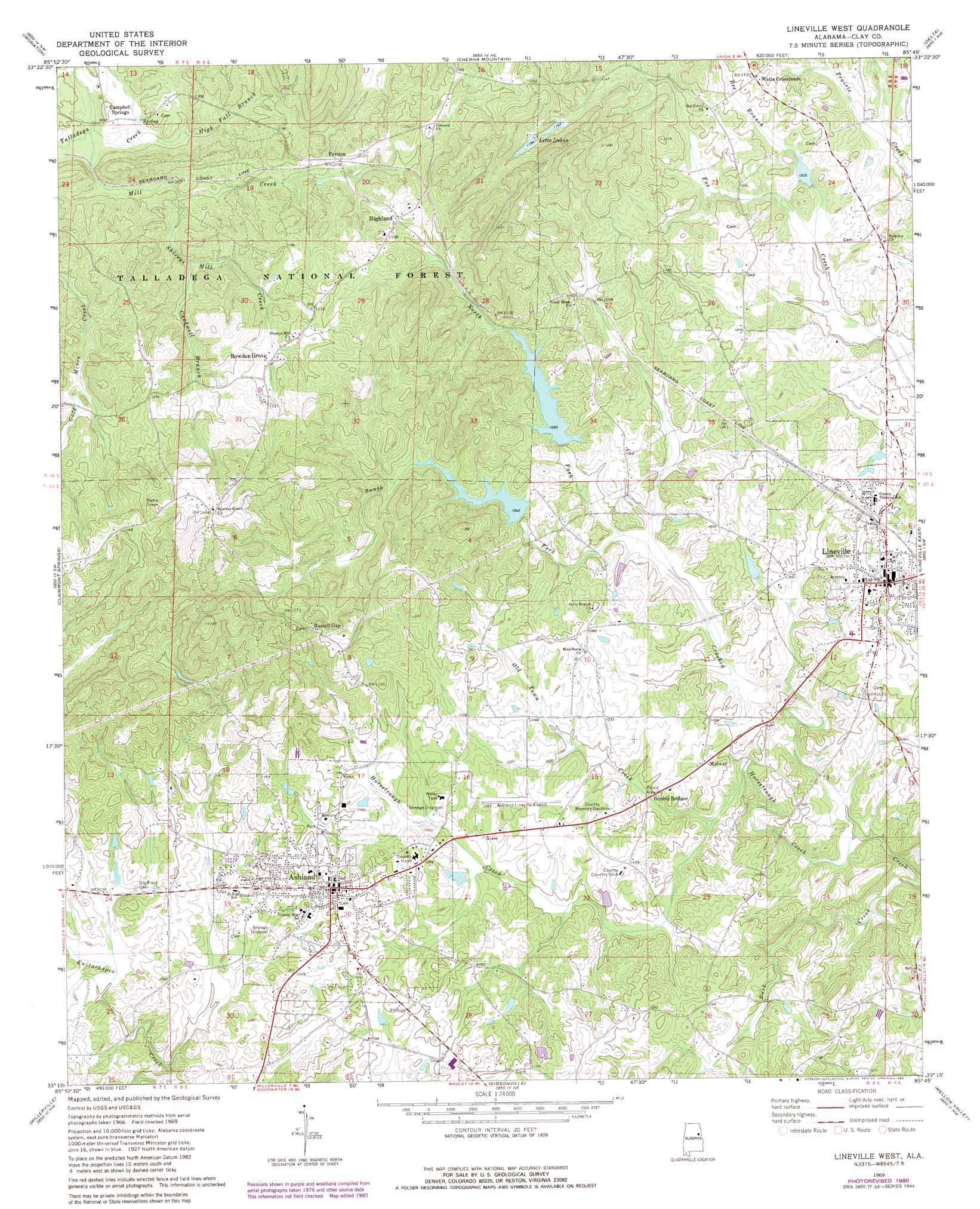
USGS Topo Quad 33085c7 - 1:24,000 scale
| Topo Map Name: | Lineville West |
| USGS Topo Quad ID: | 33085c7 |
| Print Size: | ca. 21 1/4" wide x 27" high |
| Southeast Coordinates: | 33.25° N latitude / 85.75° W longitude |
| Map Center Coordinates: | 33.3125° N latitude / 85.8125° W longitude |
| U.S. State: | AL |
| Filename: | o33085c7.jpg |
| Download Map JPG Image: | Lineville West topo map 1:24,000 scale |
| Map Type: | Topographic |
| Topo Series: | 7.5´ |
| Map Scale: | 1:24,000 |
| Source of Map Images: | United States Geological Survey (USGS) |
| Alternate Map Versions: |
Lineville West AL 1969, updated 1974 Download PDF Buy paper map Lineville West AL 1969, updated 1980 Download PDF Buy paper map Lineville West AL 2011 Download PDF Buy paper map Lineville West AL 2014 Download PDF Buy paper map |
| FStopo: | US Forest Service topo Lineville West is available: Download FStopo PDF Download FStopo TIF |
1:24,000 Topo Quads surrounding Lineville West
Eastaboga |
Munford |
Oxford |
Hollis Crossroads |
Ross Mountain |
Talladega |
Ironaton |
Cheaha Mountain |
Delta |
Micaville |
Porter Gap |
Clairmont Springs |
Lineville West |
Lineville East |
Ofelia |
Bulls Gap |
Millerville |
Gibsonville |
Mellow Valley |
Wadley North |
Goodwater |
Hackneyville |
New Site |
Daviston |
Wadley South |
> Back to 33085a1 at 1:100,000 scale
> Back to 33084a1 at 1:250,000 scale
> Back to U.S. Topo Maps home
Lineville West topo map: Gazetteer
Lineville West: Airports
Ashland-Lineville Airport elevation 311m 1020′Lineville West: Dams
Crooked Creek Watershed Dam Number 2 elevation 300m 984′Crooked Creek Watershed Dam Number 3 elevation 304m 997′
Crooked Creek Watershed Dam Number 5 elevation 318m 1043′
Fox Creek Watershed Dam Number 2 elevation 337m 1105′
McCrary Dam elevation 306m 1003′
Lineville West: Gaps
Lee Gap elevation 322m 1056′Lineville West: Mines
Alabama Gold and Mica Mine elevation 392m 1286′American Mine elevation 364m 1194′
Barrett Mine elevation 442m 1450′
Campbell Prospect elevation 341m 1118′
Carbon Mountain Mine elevation 328m 1076′
Carpenter Mine elevation 303m 994′
Clay County Mine elevation 378m 1240′
Crystalline Flake Mine elevation 371m 1217′
Four Pits Prospect elevation 378m 1240′
Gopher Mine elevation 366m 1200′
Hodge Mine elevation 393m 1289′
Hurst Mine elevation 377m 1236′
Jenkins Prospect elevation 294m 964′
Jennings Graphite Mine elevation 356m 1167′
King Mine elevation 420m 1377′
Lett Prospect elevation 373m 1223′
Lineville Mine elevation 385m 1263′
May Mine elevation 361m 1184′
McCain Prospect elevation 375m 1230′
McClure Number One Prospect elevation 385m 1263′
Monitor Mine elevation 364m 1194′
Peerless Mine elevation 318m 1043′
Republic Mine elevation 402m 1318′
Robinson Prospect elevation 360m 1181′
Rudd Prospect elevation 315m 1033′
Smith Mine elevation 376m 1233′
Southern Mine elevation 349m 1145′
Lineville West: Populated Places
Ashland elevation 341m 1118′Bowden Grove elevation 350m 1148′
Campbell Springs elevation 312m 1023′
Concord elevation 385m 1263′
Highland elevation 356m 1167′
Lineville elevation 322m 1056′
Midway elevation 314m 1030′
Pyriton elevation 326m 1069′
Watts Crossroads elevation 342m 1122′
Lineville West: Reservoirs
City Lake elevation 300m 984′Clarks Lake elevation 337m 1105′
Lake McCrary elevation 306m 1003′
Letts Lakes elevation 364m 1194′
Lineville Lake elevation 304m 997′
Lineville West: Ridges
Sanduski Ridge elevation 343m 1125′Lineville West: Streams
Bee Branch elevation 306m 1003′Cardwell Branch elevation 319m 1046′
High Fall Branch elevation 292m 958′
Horsetrough Creek elevation 274m 898′
Mill Creek elevation 289m 948′
North Fork Crooked Creek elevation 296m 971′
Old Town Creek elevation 291m 954′
Shireys Mill Creek elevation 298m 977′
South Fork Crooked Creek elevation 296m 971′
Lineville West digital topo map on disk
Buy this Lineville West topo map showing relief, roads, GPS coordinates and other geographical features, as a high-resolution digital map file on DVD: