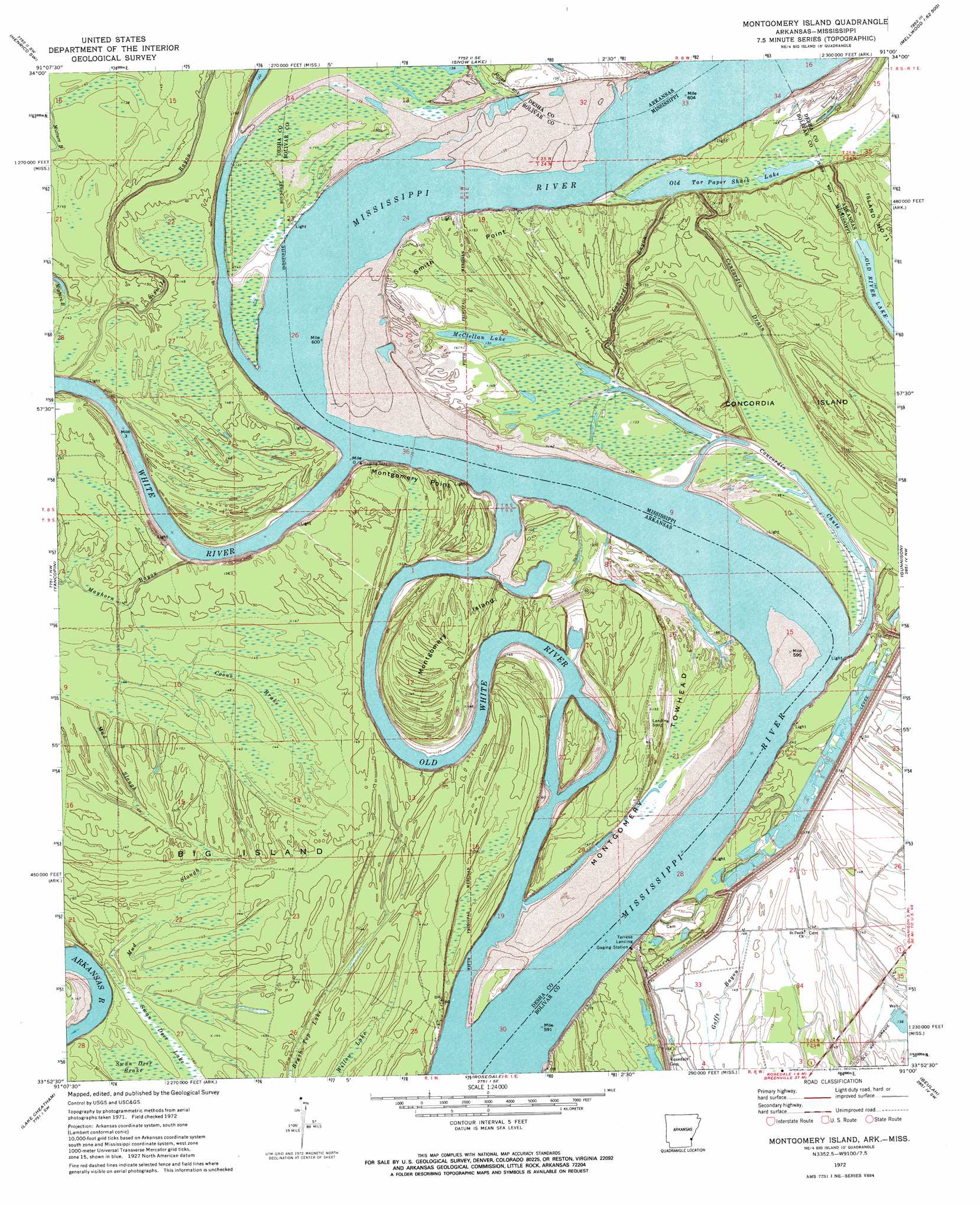
Montgomery Island Topo Map Arkansas
To zoom in, hover over the map of Montgomery Island
USGS Topo Quad 33091h1 - 1:24,000 scale
| Topo Map Name: | Montgomery Island |
| USGS Topo Quad ID: | 33091h1 |
| Print Size: | ca. 21 1/4" wide x 27" high |
| Southeast Coordinates: | 33.875° N latitude / 91° W longitude |
| Map Center Coordinates: | 33.9375° N latitude / 91.0625° W longitude |
| U.S. States: | AR, MS |
| Filename: | o33091h1.jpg |
| Download Map JPG Image: | Montgomery Island topo map 1:24,000 scale |
| Map Type: | Topographic |
| Topo Series: | 7.5´ |
| Map Scale: | 1:24,000 |
| Source of Map Images: | United States Geological Survey (USGS) |
| Alternate Map Versions: |
Montgomery Island AR 1972, updated 1974 Download PDF Buy paper map Montgomery Island AR 2011 Download PDF Buy paper map Montgomery Island AR 2014 Download PDF Buy paper map |
1:24,000 Topo Quads surrounding Montgomery Island
Tichnor |
Weber |
Henrico Ne |
Mellwood |
Rena Lara |
Arkansas Post |
Henrico Sw |
Snow Lake |
Laconia |
Round Lake |
Watson |
Yancopin |
Montgomery Island |
Gunnison |
Shelby |
Kelso |
Lake Cheatham |
Rosedale |
Beulah |
Pace |
Mcarthur |
Catfish Point |
Benoit |
Lobdell |
Skene |
> Back to 33091e1 at 1:100,000 scale
> Back to 33090a1 at 1:250,000 scale
> Back to U.S. Topo Maps home
Montgomery Island topo map: Gazetteer
Montgomery Island: Bars
Little Red Bar elevation 37m 121′Montgomery Island: Bends
Birmingham Bend elevation 43m 141′Concordia Bend (historical) elevation 43m 141′
Jackson Bend elevation 40m 131′
Montgomery Bend elevation 42m 137′
Scrubgrass Bend elevation 43m 141′
Victoria Bend elevation 40m 131′
Montgomery Island: Capes
Montgomery Point elevation 48m 157′Smith Point elevation 44m 144′
Montgomery Island: Channels
Montgomery Cutoff elevation 41m 134′Montgomery Island: Flats
Big Island elevation 46m 150′Montgomery Island: Guts
Concordia Chute elevation 38m 124′Mud Slough elevation 43m 141′
Sixmile Bayou elevation 48m 157′
Montgomery Island: Islands
Concordia Island elevation 47m 154′Montgomery Island elevation 48m 157′
Montgomery Towhead elevation 46m 150′
Montgomery Island: Lakes
McClellan Lake elevation 40m 131′Old Tar Paper Shack Lake elevation 40m 131′
Montgomery Island: Levees
Big Island Revetment elevation 42m 137′Henrico Dikes elevation 43m 141′
Montgomery Towhead Dikes elevation 42m 137′
Scrubgrass Bend Revetment elevation 42m 137′
White River Landing Dikes elevation 37m 121′
Montgomery Island: Populated Places
Terrene Landing elevation 44m 144′White River elevation 44m 144′
Montgomery Island: Streams
Concordia Bayou elevation 39m 127′Concordia Drain elevation 40m 131′
Mayhorn Bayou elevation 43m 141′
Old White River elevation 39m 127′
White River elevation 42m 137′
Montgomery Island: Swamps
Brush Top Lake elevation 47m 154′Coono Brake elevation 45m 147′
Swan Deer Lake elevation 42m 137′
Willow Lake elevation 44m 144′
Montgomery Island digital topo map on disk
Buy this Montgomery Island topo map showing relief, roads, GPS coordinates and other geographical features, as a high-resolution digital map file on DVD: