Arkansas Post Topo Map Arkansas
To zoom in, hover over the map of Arkansas Post
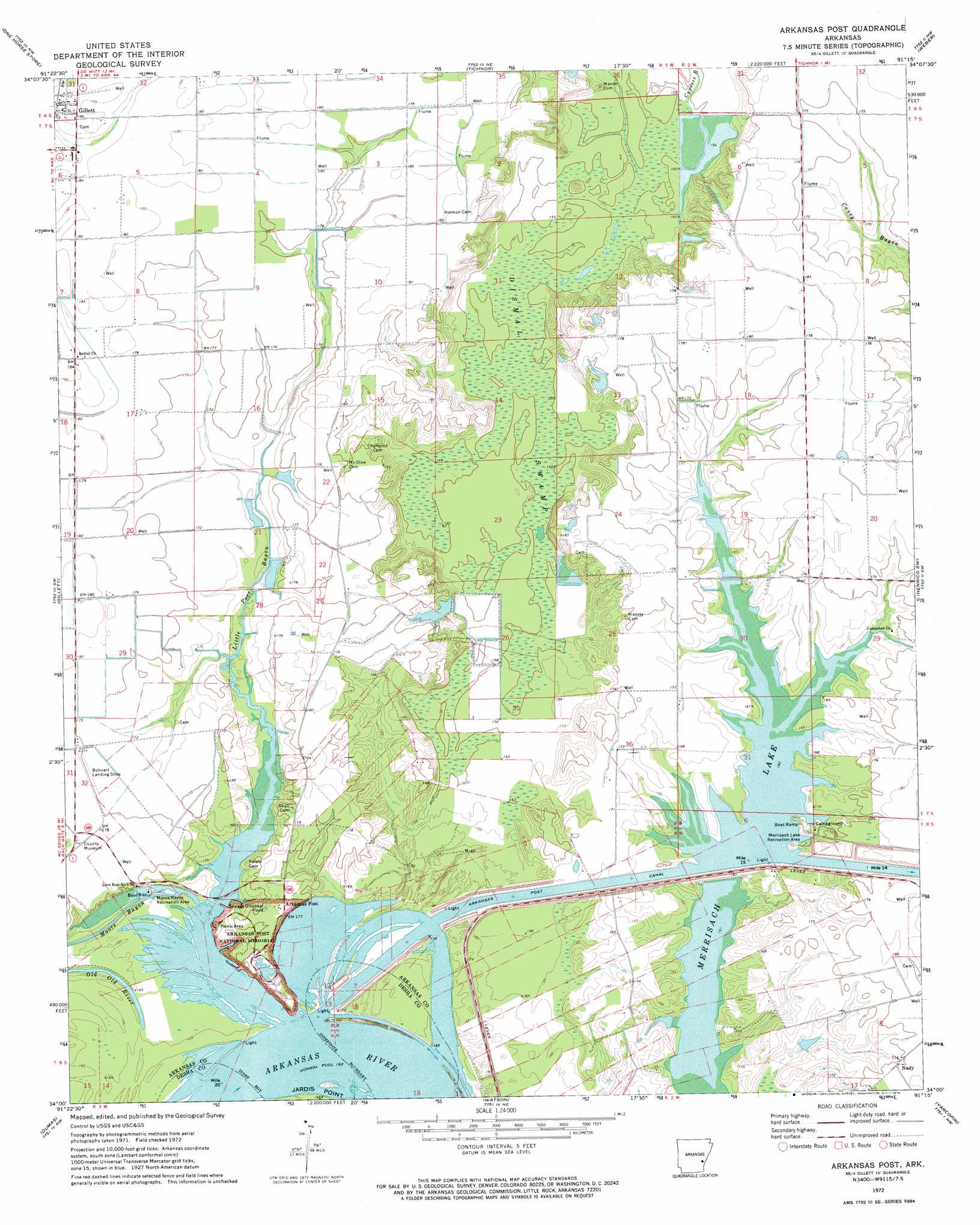
USGS Topo Quad 34091a3 - 1:24,000 scale
| Topo Map Name: | Arkansas Post |
| USGS Topo Quad ID: | 34091a3 |
| Print Size: | ca. 21 1/4" wide x 27" high |
| Southeast Coordinates: | 34° N latitude / 91.25° W longitude |
| Map Center Coordinates: | 34.0625° N latitude / 91.3125° W longitude |
| U.S. State: | AR |
| Filename: | o34091a3.jpg |
| Download Map JPG Image: | Arkansas Post topo map 1:24,000 scale |
| Map Type: | Topographic |
| Topo Series: | 7.5´ |
| Map Scale: | 1:24,000 |
| Source of Map Images: | United States Geological Survey (USGS) |
| Alternate Map Versions: |
Arkansas Post AR 1972, updated 1974 Download PDF Buy paper map Arkansas Post AR 2011 Download PDF Buy paper map Arkansas Post AR 2014 Download PDF Buy paper map |
1:24,000 Topo Quads surrounding Arkansas Post
Lodge Corner |
De Witt Sw |
De Witt |
Ethel |
Indian Bay Se |
Reydell |
One Horse Store |
Tichnor |
Weber |
Henrico Ne |
Cades |
Gillett |
Arkansas Post |
Henrico Sw |
Snow Lake |
Gould |
Dumas |
Watson |
Yancopin |
Montgomery Island |
Gourd |
Winchester |
Kelso |
Lake Cheatham |
Rosedale |
> Back to 34091a1 at 1:100,000 scale
> Back to 34090a1 at 1:250,000 scale
> Back to U.S. Topo Maps home
Arkansas Post topo map: Gazetteer
Arkansas Post: Bends
Post Bend elevation 49m 160′Arkansas Post: Canals
Arkansas Post Canal elevation 48m 157′Arkansas Post: Cliffs
Ecores Rouges elevation 51m 167′Arkansas Post: Crossings
Burr Crossing (historical) elevation 47m 154′Arkansas Post: Dams
Parish Lake Dam elevation 48m 157′Arkansas Post: Lakes
Merrisach Lake elevation 48m 157′Old Old River elevation 51m 167′
Park Lake elevation 52m 170′
Arkansas Post: Parks
Merrisach Lake Recreation Area elevation 50m 164′Moore Bayou Recreation Area elevation 48m 157′
Arkansas Post: Populated Places
Arkansas (historical) elevation 53m 173′Arkansas Post elevation 54m 177′
Arkansas Post: Reservoirs
Parish Lake elevation 48m 157′Arkansas Post: Streams
Alligator Slough elevation 49m 160′Little Post Bayou elevation 48m 157′
Moore Bayou elevation 48m 157′
Post Bayou elevation 49m 160′
Arkansas Post: Swamps
Dismal Swamp elevation 49m 160′Arkansas Post digital topo map on disk
Buy this Arkansas Post topo map showing relief, roads, GPS coordinates and other geographical features, as a high-resolution digital map file on DVD: