Snow Lake Topo Map Arkansas
To zoom in, hover over the map of Snow Lake
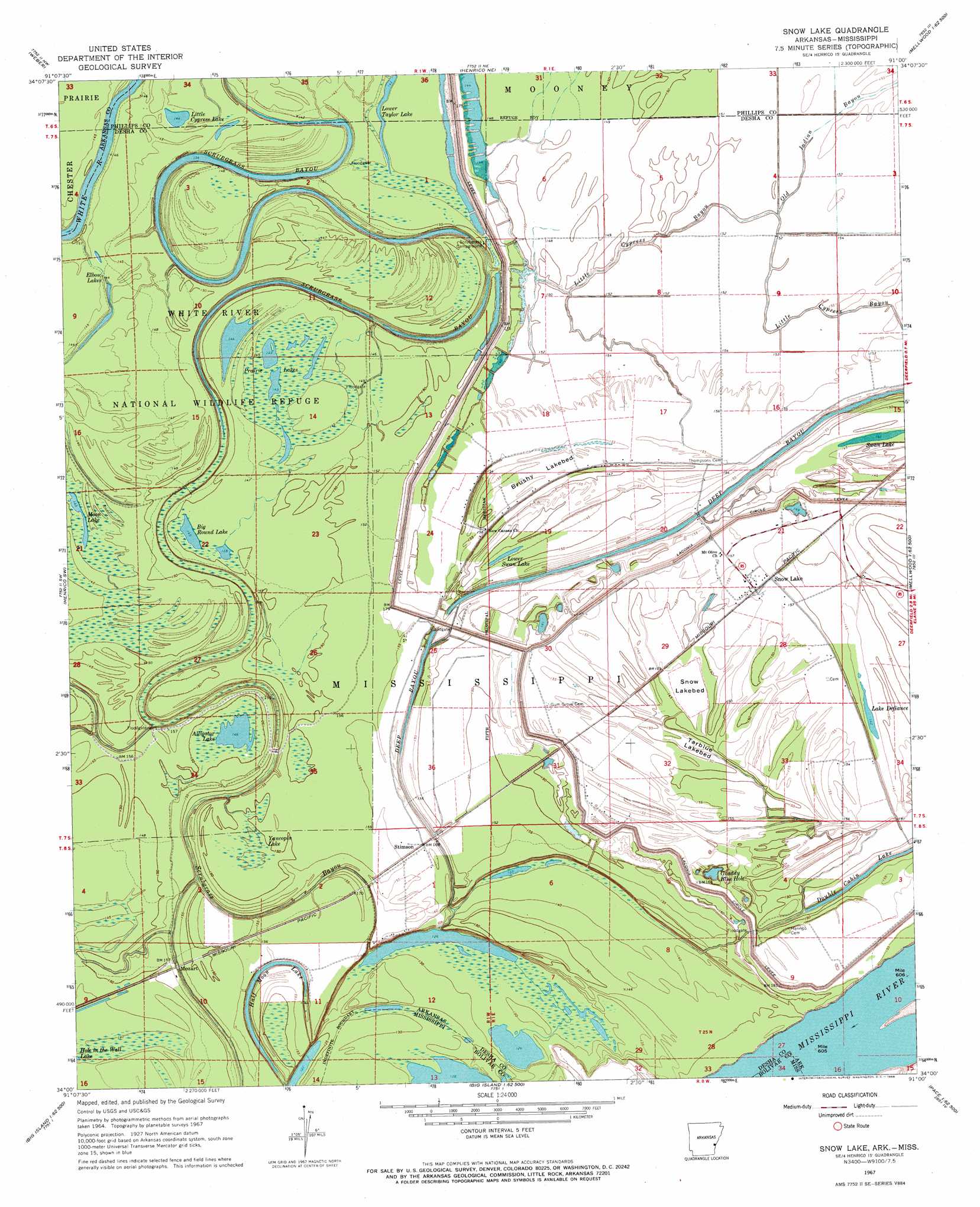
USGS Topo Quad 34091a1 - 1:24,000 scale
| Topo Map Name: | Snow Lake |
| USGS Topo Quad ID: | 34091a1 |
| Print Size: | ca. 21 1/4" wide x 27" high |
| Southeast Coordinates: | 34° N latitude / 91° W longitude |
| Map Center Coordinates: | 34.0625° N latitude / 91.0625° W longitude |
| U.S. States: | AR, MS |
| Filename: | o34091a1.jpg |
| Download Map JPG Image: | Snow Lake topo map 1:24,000 scale |
| Map Type: | Topographic |
| Topo Series: | 7.5´ |
| Map Scale: | 1:24,000 |
| Source of Map Images: | United States Geological Survey (USGS) |
| Alternate Map Versions: |
Snow Lake AR 1967, updated 1968 Download PDF Buy paper map Snow Lake AR 1967, updated 1978 Download PDF Buy paper map Snow Lake AR 2011 Download PDF Buy paper map Snow Lake AR 2014 Download PDF Buy paper map |
1:24,000 Topo Quads surrounding Snow Lake
De Witt |
Ethel |
Indian Bay Se |
Lambrook |
Elaine |
Tichnor |
Weber |
Henrico Ne |
Mellwood |
Rena Lara |
Arkansas Post |
Henrico Sw |
Snow Lake |
Laconia |
Round Lake |
Watson |
Yancopin |
Montgomery Island |
Gunnison |
Shelby |
Kelso |
Lake Cheatham |
Rosedale |
Beulah |
Pace |
> Back to 34091a1 at 1:100,000 scale
> Back to 34090a1 at 1:250,000 scale
> Back to U.S. Topo Maps home
Snow Lake topo map: Gazetteer
Snow Lake: Bars
Henrico Bar elevation 46m 150′Snow Lake: Flats
Brushy Lakebed elevation 47m 154′Snow Lakebed elevation 41m 134′
Tarblue Lakebed elevation 42m 137′
Snow Lake: Guts
Old Indian Bayou elevation 46m 150′Snow Lake: Lakes
Alligator Lake elevation 44m 144′Bear Lake (historical) elevation 45m 147′
Big Round Lake elevation 46m 150′
Elbow Lakes elevation 44m 144′
Graddy Blue Hole elevation 44m 144′
Half Moon Lake elevation 44m 144′
Lake Defiance elevation 42m 137′
Little Cypress Lake elevation 44m 144′
Lower Swan Lake elevation 44m 144′
Moon Lake elevation 43m 141′
Prairie Lakes elevation 44m 144′
Snow Lake (historical) elevation 41m 134′
Swan Lake elevation 42m 137′
Tarblue Lake (historical) elevation 42m 137′
Snow Lake: Levees
Laconia Circle Levee elevation 50m 164′Snow Lake: Populated Places
Henrico (historical) elevation 49m 160′Mozart elevation 46m 150′
Snow Lake elevation 47m 154′
Stimson elevation 48m 157′
Snow Lake: Streams
Deep Bayou elevation 42m 137′Little Cypress Bayou elevation 45m 147′
Sixmile Bayou elevation 45m 147′
Snow Lake: Swamps
Yancopin Lake elevation 49m 160′Snow Lake digital topo map on disk
Buy this Snow Lake topo map showing relief, roads, GPS coordinates and other geographical features, as a high-resolution digital map file on DVD: