Skene Topo Map Mississippi
To zoom in, hover over the map of Skene
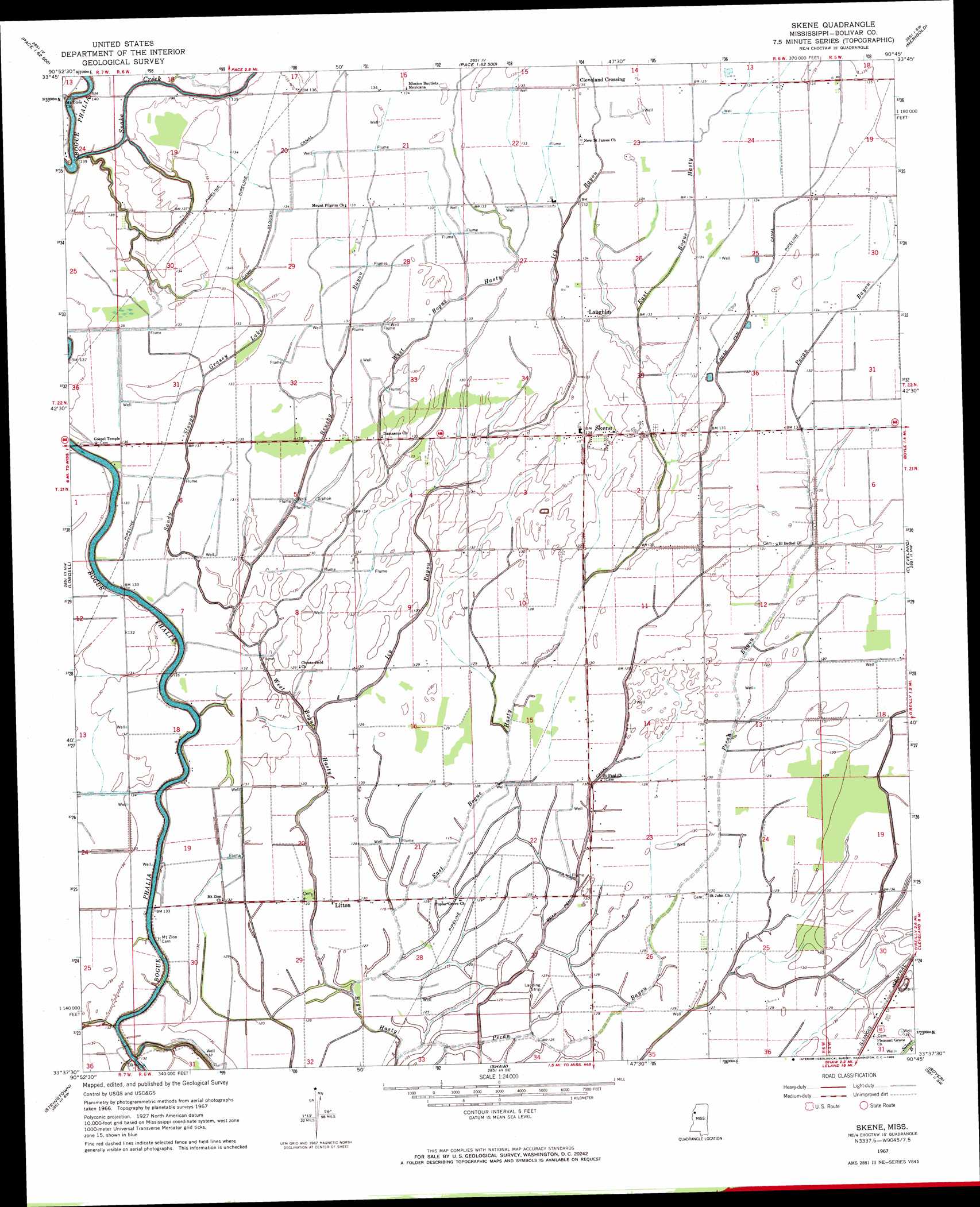
USGS Topo Quad 33090f7 - 1:24,000 scale
| Topo Map Name: | Skene |
| USGS Topo Quad ID: | 33090f7 |
| Print Size: | ca. 21 1/4" wide x 27" high |
| Southeast Coordinates: | 33.625° N latitude / 90.75° W longitude |
| Map Center Coordinates: | 33.6875° N latitude / 90.8125° W longitude |
| U.S. State: | MS |
| Filename: | o33090f7.jpg |
| Download Map JPG Image: | Skene topo map 1:24,000 scale |
| Map Type: | Topographic |
| Topo Series: | 7.5´ |
| Map Scale: | 1:24,000 |
| Source of Map Images: | United States Geological Survey (USGS) |
| Alternate Map Versions: |
Skene MS 1967, updated 1968 Download PDF Buy paper map Skene MS 2012 Download PDF Buy paper map Skene MS 2015 Download PDF Buy paper map |
1:24,000 Topo Quads surrounding Skene
Montgomery Island |
Gunnison |
Shelby |
Mound Bayou |
Baltzer |
Rosedale |
Beulah |
Pace |
Merigold |
Drew |
Benoit |
Lobdell |
Skene |
Cleveland |
Ruleville |
Scott |
Stringtown |
Shaw |
Boyer |
Sunflower |
Greenville |
Leland |
Holly Ridge |
Indianola |
Moorhead |
> Back to 33090e1 at 1:100,000 scale
> Back to 33090a1 at 1:250,000 scale
> Back to U.S. Topo Maps home
Skene topo map: Gazetteer
Skene: Canals
Bear Pen Canal elevation 37m 121′Camp Slough Canal elevation 38m 124′
Ditch Number E-3 elevation 39m 127′
Ditch Number E-5 elevation 38m 124′
Ditch Number E-7 elevation 38m 124′
Ditch Number Four elevation 37m 121′
Ditch Number Four elevation 39m 127′
Ditch Number Nine elevation 38m 124′
Ditch Number One elevation 37m 121′
Ditch Number Seventeen elevation 40m 131′
Ditch Number Ten elevation 38m 124′
Ditch Number Three elevation 39m 127′
Ditch Number Twenty elevation 41m 134′
Ditch Number Twentyeight elevation 39m 127′
Ditch Number Twentynine elevation 39m 127′
Ditch Number Twentysix elevation 38m 124′
Skene: Dams
Judge Brizzell Pond Dam elevation 41m 134′Skene: Parks
Bear Pen Park elevation 39m 127′Skene: Populated Places
Cleveland Crossing elevation 41m 134′Laughlin elevation 39m 127′
Litton elevation 40m 131′
Skene elevation 40m 131′
Skene: Streams
Brushy Bayou elevation 37m 121′East Bogue Hasty elevation 35m 114′
Grassy Lake elevation 37m 121′
Icy Bayou elevation 36m 118′
Pecan Bayou elevation 36m 118′
Sandy Slough elevation 36m 118′
Snake Creek elevation 35m 114′
West Bogue Hasty elevation 35m 114′
Skene digital topo map on disk
Buy this Skene topo map showing relief, roads, GPS coordinates and other geographical features, as a high-resolution digital map file on DVD: