El Capitan Mountain Topo Map Arizona
To zoom in, hover over the map of El Capitan Mountain
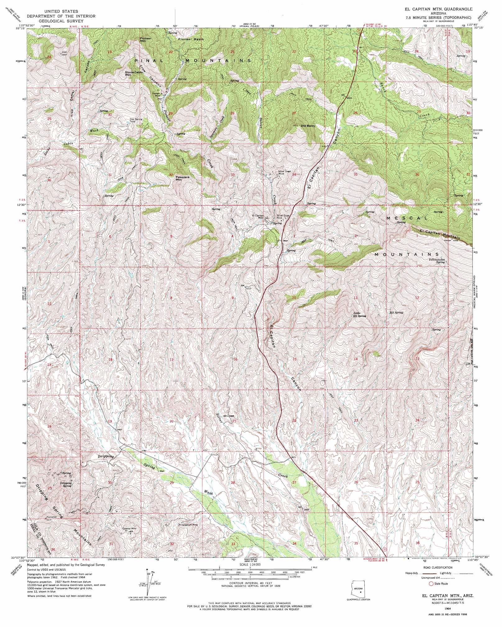
USGS Topo Quad 33110b7 - 1:24,000 scale
| Topo Map Name: | El Capitan Mountain |
| USGS Topo Quad ID: | 33110b7 |
| Print Size: | ca. 21 1/4" wide x 27" high |
| Southeast Coordinates: | 33.125° N latitude / 110.75° W longitude |
| Map Center Coordinates: | 33.1875° N latitude / 110.8125° W longitude |
| U.S. State: | AZ |
| Filename: | o33110b7.jpg |
| Download Map JPG Image: | El Capitan Mountain topo map 1:24,000 scale |
| Map Type: | Topographic |
| Topo Series: | 7.5´ |
| Map Scale: | 1:24,000 |
| Source of Map Images: | United States Geological Survey (USGS) |
| Alternate Map Versions: |
El Capitan Mtn AZ 1964, updated 1965 Download PDF Buy paper map El Capitan Mtn AZ 1964, updated 1975 Download PDF Buy paper map El Capitan Mountain AZ 2011 Download PDF Buy paper map El Capitan Mountain AZ 2014 Download PDF Buy paper map |
| FStopo: | US Forest Service topo El Capitan Mountain is available: Download FStopo PDF Download FStopo TIF |
1:24,000 Topo Quads surrounding El Capitan Mountain
Haunted Canyon |
Inspiration |
Globe |
Cammerman Wash |
Dourine Canyon |
Superior |
Pinal Ranch |
Pinal Peak |
Cutter |
Bucket Mountain |
Teapot Mountain |
Hot Tamale Peak |
El Capitan Mountain |
Mescal Warm Spring |
Coolidge Dam |
Grayback |
Kearny |
Hayden |
Christmas |
Jerusalem Mountain |
Ninetysix Hills Ne |
Crozier Peak |
Winkelman |
Dudleyville |
Brandenburg Mountain |
> Back to 33110a1 at 1:100,000 scale
> Back to 33110a1 at 1:250,000 scale
> Back to U.S. Topo Maps home
El Capitan Mountain topo map: Gazetteer
El Capitan Mountain: Mines
Cowboy Mine elevation 1062m 3484′El Capitan Mine elevation 1129m 3704′
Pioneer Mine elevation 1390m 4560′
Silver Creek Mine elevation 0m 0′
Silver Dime Mine elevation 0m 0′
Vanadium Mine elevation 874m 2867′
El Capitan Mountain: Reservoirs
Oak Spring Tank elevation 1410m 4625′El Capitan Mountain: Springs
Dripping Spring elevation 1021m 3349′Little RS Spring elevation 1292m 4238′
RS Spring elevation 1205m 3953′
Yellowjacket Spring elevation 1770m 5807′
El Capitan Mountain: Streams
Pioneer Creek elevation 1058m 3471′Sycamore Creek elevation 1219m 3999′
El Capitan Mountain: Summits
El Capitan Mountain elevation 2004m 6574′Old Baldy elevation 1675m 5495′
Pasadera Mountain elevation 1552m 5091′
Pioneer Mountain elevation 1817m 5961′
Stone Cabin Mountain elevation 1747m 5731′
El Capitan Mountain: Valleys
Crow Canyon elevation 1375m 4511′El Capitan Canyon elevation 805m 2641′
Gilson Wash elevation 1366m 4481′
Gilson Wash elevation 1367m 4484′
Trap Corral Canyon elevation 1244m 4081′
El Capitan Mountain digital topo map on disk
Buy this El Capitan Mountain topo map showing relief, roads, GPS coordinates and other geographical features, as a high-resolution digital map file on DVD: