Brandenburg Mountain Topo Map Arizona
To zoom in, hover over the map of Brandenburg Mountain
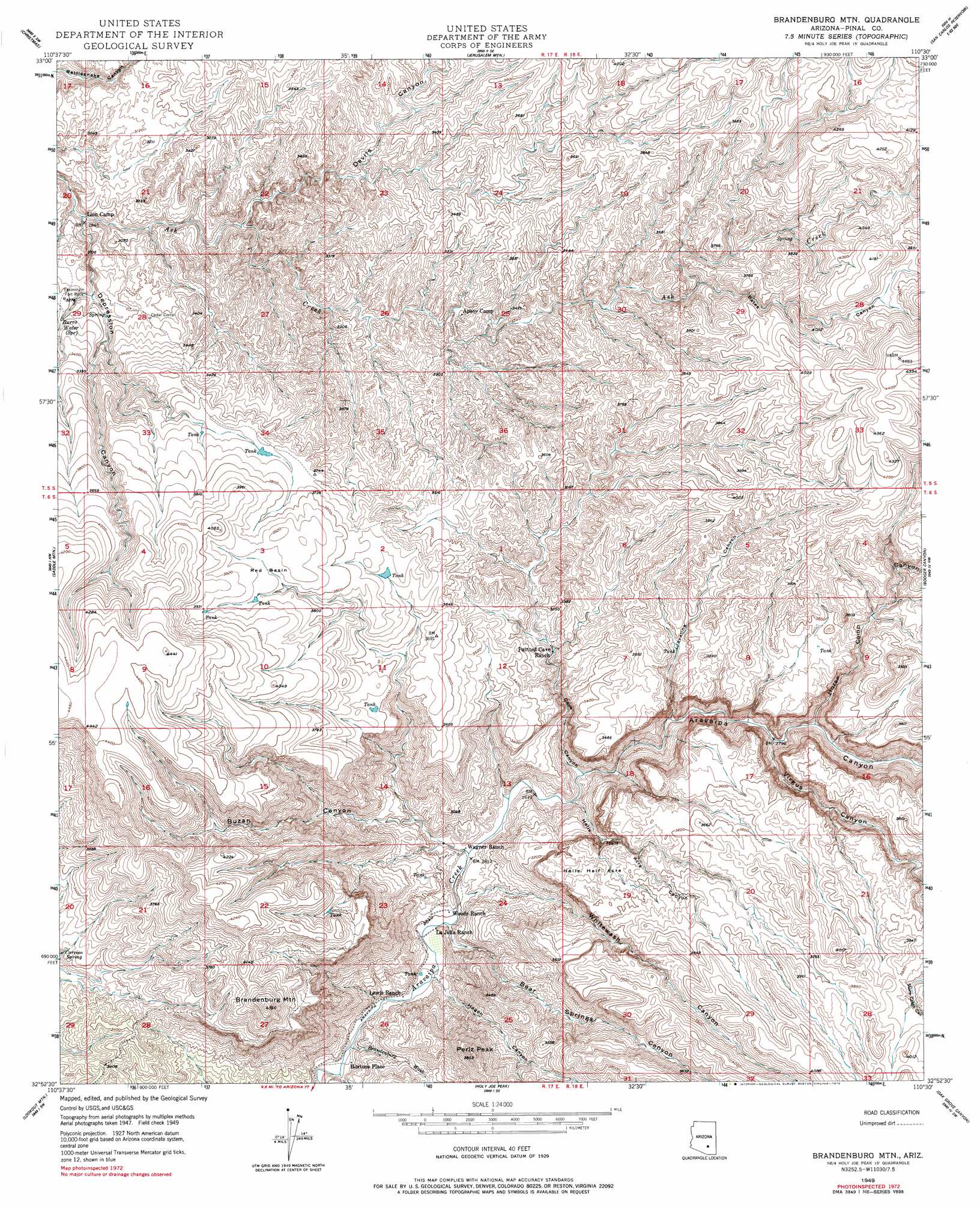
USGS Topo Quad 32110h5 - 1:24,000 scale
| Topo Map Name: | Brandenburg Mountain |
| USGS Topo Quad ID: | 32110h5 |
| Print Size: | ca. 21 1/4" wide x 27" high |
| Southeast Coordinates: | 32.875° N latitude / 110.5° W longitude |
| Map Center Coordinates: | 32.9375° N latitude / 110.5625° W longitude |
| U.S. State: | AZ |
| Filename: | o32110h5.jpg |
| Download Map JPG Image: | Brandenburg Mountain topo map 1:24,000 scale |
| Map Type: | Topographic |
| Topo Series: | 7.5´ |
| Map Scale: | 1:24,000 |
| Source of Map Images: | United States Geological Survey (USGS) |
| Alternate Map Versions: |
Brandenburg Mtn AZ 1949, updated 1962 Download PDF Buy paper map Brandenburg Mtn AZ 1949, updated 1975 Download PDF Buy paper map Brandenburg Mtn AZ 1949, updated 1979 Download PDF Buy paper map Brandenburg Mtn AZ 1950, updated 1950 Download PDF Buy paper map Brandenburg Mountain AZ 2011 Download PDF Buy paper map Brandenburg Mountain AZ 2014 Download PDF Buy paper map |
1:24,000 Topo Quads surrounding Brandenburg Mountain
El Capitan Mountain |
Mescal Warm Spring |
Coolidge Dam |
San Carlos Reservoir |
Dewey Flat |
Hayden |
Christmas |
Jerusalem Mountain |
Rawhide Mountain |
Mount Turnbull |
Winkelman |
Dudleyville |
Brandenburg Mountain |
Booger Canyon |
Cobre Grande Mountain |
Putnam Wash |
Lookout Mountain |
Holy Joe Peak |
Oak Grove Canyon |
Klondike |
North Of Oracle |
Mammoth |
Clark Ranch |
Rhodes Peak |
Kennedy Peak |
> Back to 32110e1 at 1:100,000 scale
> Back to 32110a1 at 1:250,000 scale
> Back to U.S. Topo Maps home
Brandenburg Mountain topo map: Gazetteer
Brandenburg Mountain: Areas
Hells Half Acre elevation 1063m 3487′Brandenburg Mountain: Basins
Red Basin elevation 1173m 3848′Brandenburg Mountain: Pillars
Eskiminzin Fort Rock elevation 987m 3238′Brandenburg Mountain: Populated Places
Hortons Place elevation 774m 2539′Brandenburg Mountain: Springs
Burro Water Spring elevation 974m 3195′Eskiminzin Spring elevation 954m 3129′
Brandenburg Mountain: Streams
Brandenburg Wash elevation 768m 2519′Brandenburg Mountain: Summits
Brandenburg Mountain elevation 1328m 4356′Periz Peak elevation 1175m 3854′
Brandenburg Mountain: Valleys
Bates Canyon elevation 1041m 3415′Bear Springs Canyon elevation 790m 2591′
Buzan Canyon elevation 812m 2664′
Cave Canyon elevation 813m 2667′
Depression Canyon elevation 865m 2837′
Devils Canyon elevation 902m 2959′
Hagen Canyon elevation 788m 2585′
Hells Half Acre Canyon elevation 833m 2732′
Horse Camp Canyon elevation 858m 2814′
Javalina Canyon elevation 838m 2749′
Virgus Canyon elevation 853m 2798′
Whitewash Canyon elevation 802m 2631′
Brandenburg Mountain digital topo map on disk
Buy this Brandenburg Mountain topo map showing relief, roads, GPS coordinates and other geographical features, as a high-resolution digital map file on DVD: