Teapot Mountain Topo Map Arizona
To zoom in, hover over the map of Teapot Mountain
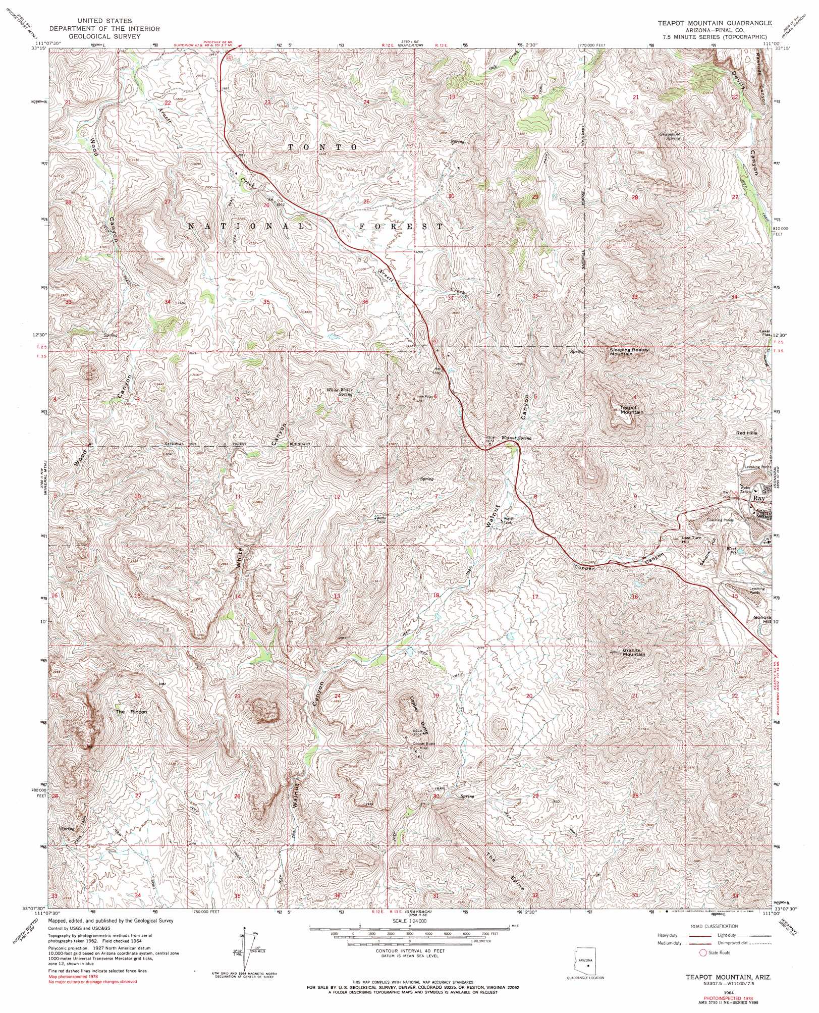
USGS Topo Quad 33111b1 - 1:24,000 scale
| Topo Map Name: | Teapot Mountain |
| USGS Topo Quad ID: | 33111b1 |
| Print Size: | ca. 21 1/4" wide x 27" high |
| Southeast Coordinates: | 33.125° N latitude / 111° W longitude |
| Map Center Coordinates: | 33.1875° N latitude / 111.0625° W longitude |
| U.S. State: | AZ |
| Filename: | o33111b1.jpg |
| Download Map JPG Image: | Teapot Mountain topo map 1:24,000 scale |
| Map Type: | Topographic |
| Topo Series: | 7.5´ |
| Map Scale: | 1:24,000 |
| Source of Map Images: | United States Geological Survey (USGS) |
| Alternate Map Versions: |
Teapot Mountain AZ 1964, updated 1965 Download PDF Buy paper map Teapot Mountain AZ 1964, updated 1973 Download PDF Buy paper map Teapot Mountain AZ 1964, updated 1990 Download PDF Buy paper map Teapot Mountain AZ 2004, updated 2007 Download PDF Buy paper map Teapot Mountain AZ 2011 Download PDF Buy paper map Teapot Mountain AZ 2014 Download PDF Buy paper map |
| FStopo: | US Forest Service topo Teapot Mountain is available: Download FStopo PDF Download FStopo TIF |
1:24,000 Topo Quads surrounding Teapot Mountain
Weavers Needle |
Iron Mountain |
Haunted Canyon |
Inspiration |
Globe |
Florence Junction |
Picketpost Mountain |
Superior |
Pinal Ranch |
Pinal Peak |
Florence Ne |
Mineral Mountain |
Teapot Mountain |
Hot Tamale Peak |
El Capitan Mountain |
Florence Se |
North Butte |
Grayback |
Kearny |
Hayden |
Cactus Forest |
Ninetysix Hills Nw |
Ninetysix Hills Ne |
Crozier Peak |
Winkelman |
> Back to 33111a1 at 1:100,000 scale
> Back to 33110a1 at 1:250,000 scale
> Back to U.S. Topo Maps home
Teapot Mountain topo map: Gazetteer
Teapot Mountain: Basins
The Rincon elevation 830m 2723′Teapot Mountain: Flats
Lakel Flat elevation 669m 2194′Teapot Mountain: Lakes
West Pit elevation 630m 2066′Teapot Mountain: Mines
Copper Butte Mine elevation 790m 2591′Ray Mine Open Pit elevation 747m 2450′
Teapot Mountain: Reservoirs
Black Hills Tank elevation 1043m 3421′Crucifixon Tank elevation 989m 3244′
Lime Tank elevation 964m 3162′
Lower EK tank elevation 1172m 3845′
Red Tank elevation 1232m 4041′
Teapot Mountain: Ridges
The Spine elevation 960m 3149′Teapot Mountain: Springs
Grapevine Spring elevation 937m 3074′Kanes Spring elevation 990m 3248′
Sup Hor Spring elevation 1112m 3648′
Walnut Spring elevation 958m 3143′
White Water Spring elevation 896m 2939′
Wood Canyon Spring elevation 925m 3034′
Teapot Mountain: Summits
Copper Butte elevation 973m 3192′Granite Mountain elevation 1232m 4041′
Last Turn Hill elevation 862m 2828′
Red Hills elevation 775m 2542′
Sandow Hill elevation 805m 2641′
Sleeping Beauty Mountain elevation 1332m 4370′
Sonora Hill elevation 789m 2588′
Teapot Mountain elevation 1367m 4484′
Teapot Mountain: Valleys
Copper Canyon elevation 733m 2404′Rawhide Canyon elevation 767m 2516′
White Canyon elevation 620m 2034′
Wood Canyon elevation 831m 2726′
Teapot Mountain: Wells
Arnett Well elevation 1033m 3389′Teapot Mountain digital topo map on disk
Buy this Teapot Mountain topo map showing relief, roads, GPS coordinates and other geographical features, as a high-resolution digital map file on DVD: