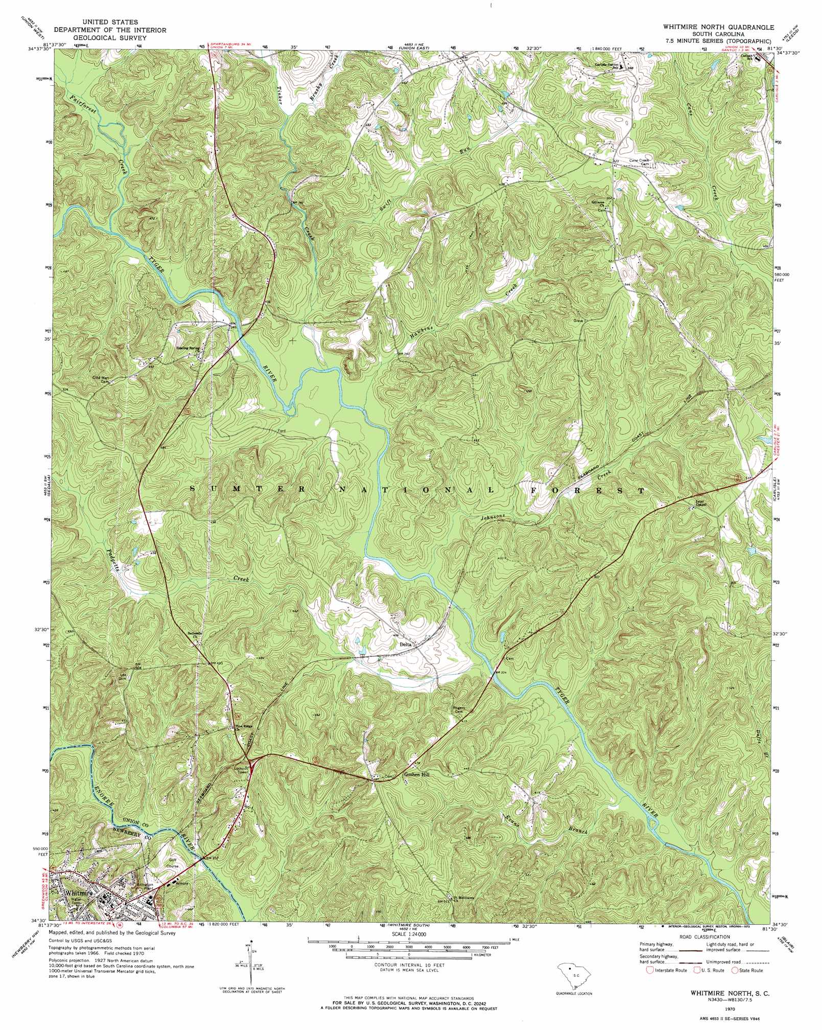
Whitmire North Topo Map South Carolina
To zoom in, hover over the map of Whitmire North
USGS Topo Quad 34081e5 - 1:24,000 scale
| Topo Map Name: | Whitmire North |
| USGS Topo Quad ID: | 34081e5 |
| Print Size: | ca. 21 1/4" wide x 27" high |
| Southeast Coordinates: | 34.5° N latitude / 81.5° W longitude |
| Map Center Coordinates: | 34.5625° N latitude / 81.5625° W longitude |
| U.S. State: | SC |
| Filename: | o34081e5.jpg |
| Download Map JPG Image: | Whitmire North topo map 1:24,000 scale |
| Map Type: | Topographic |
| Topo Series: | 7.5´ |
| Map Scale: | 1:24,000 |
| Source of Map Images: | United States Geological Survey (USGS) |
| Alternate Map Versions: |
Whitmire North SC 1970, updated 1973 Download PDF Buy paper map Whitmire North SC 2011 Download PDF Buy paper map Whitmire North SC 2014 Download PDF Buy paper map |
| FStopo: | US Forest Service topo Whitmire North is available: Download FStopo PDF Download FStopo TIF |
1:24,000 Topo Quads surrounding Whitmire North
Glenn Springs |
Jonesville |
Kelton |
Lockhart |
Armenia |
Cross Anchor |
Union West |
Union East |
Leeds |
Baton Rouge |
Philson Crossroads |
Sedalia |
Whitmire North |
Carlisle |
Carlisle Se |
Joanna |
Newberry Nw |
Whitmire South |
Blair |
Salem Crossroads |
Bush River |
Newberry West |
Newberry East |
Pomaria |
Jenkinsville |
> Back to 34081e1 at 1:100,000 scale
> Back to 34080a1 at 1:250,000 scale
> Back to U.S. Topo Maps home
Whitmire North topo map: Gazetteer
Whitmire North: Bridges
Beaty Bridge (historical) elevation 98m 321′Thorp Bridge elevation 95m 311′
Whitmire North: Crossings
Hamiltons Ford elevation 94m 308′Kennedys Ford elevation 95m 311′
Rogers Ferry (historical) elevation 94m 308′
Whitmire North: Falls
Hendricks Falls elevation 95m 311′Whitmire North: Populated Places
Ada (historical) elevation 122m 400′Beaver Dam elevation 106m 347′
Delta elevation 114m 374′
Goshen Hill elevation 139m 456′
Red Town (historical) elevation 132m 433′
Sartor Town elevation 132m 433′
Whitmire elevation 132m 433′
Whitmire North: Rapids
Hawkins Shoals elevation 92m 301′Whitmire North: Streams
Brushy Creek elevation 112m 367′Doil Creek elevation 92m 301′
Evans Branch elevation 92m 301′
Fairforest Creek elevation 101m 331′
Hawkins Creek elevation 97m 318′
Johnsons Creek elevation 95m 311′
Padgetts Creek elevation 94m 308′
Salters Creek elevation 94m 308′
Swift Run elevation 102m 334′
Tinker Creek elevation 99m 324′
Whitmire North digital topo map on disk
Buy this Whitmire North topo map showing relief, roads, GPS coordinates and other geographical features, as a high-resolution digital map file on DVD:
South Carolina, Western North Carolina & Northeastern Georgia
Buy digital topo maps: South Carolina, Western North Carolina & Northeastern Georgia