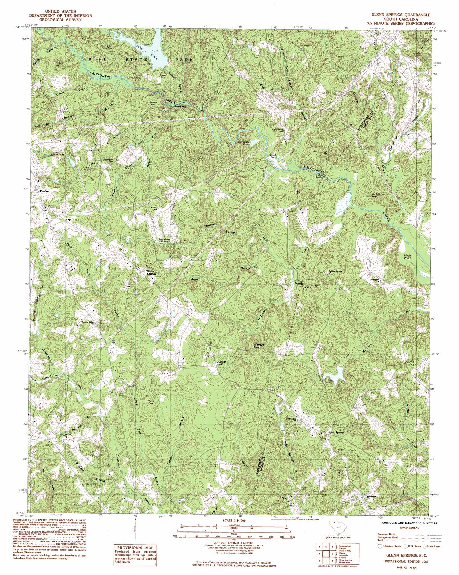
Glenn Springs Topo Map South Carolina
To zoom in, hover over the map of Glenn Springs
USGS Topo Quad 34081g7 - 1:24,000 scale
| Topo Map Name: | Glenn Springs |
| USGS Topo Quad ID: | 34081g7 |
| Print Size: | ca. 21 1/4" wide x 27" high |
| Southeast Coordinates: | 34.75° N latitude / 81.75° W longitude |
| Map Center Coordinates: | 34.8125° N latitude / 81.8125° W longitude |
| U.S. State: | SC |
| Filename: | o34081g7.jpg |
| Download Map JPG Image: | Glenn Springs topo map 1:24,000 scale |
| Map Type: | Topographic |
| Topo Series: | 7.5´ |
| Map Scale: | 1:24,000 |
| Source of Map Images: | United States Geological Survey (USGS) |
| Alternate Map Versions: |
Glenn Springs SC 1983, updated 1983 Download PDF Buy paper map Glenn Springs SC 2011 Download PDF Buy paper map Glenn Springs SC 2014 Download PDF Buy paper map |
1:24,000 Topo Quads surrounding Glenn Springs
Inman |
Valley Falls |
Cowpens |
Gaffney |
Blacksburg South |
Wellford |
Spartanburg |
Pacolet |
Pacolet Mills |
Wilkinsville |
Reidville |
Moore |
Glenn Springs |
Jonesville |
Kelton |
Woodruff |
Enoree |
Cross Anchor |
Union West |
Union East |
Laurens North |
Ora |
Philson Crossroads |
Sedalia |
Whitmire North |
> Back to 34081e1 at 1:100,000 scale
> Back to 34080a1 at 1:250,000 scale
> Back to U.S. Topo Maps home
Glenn Springs topo map: Gazetteer
Glenn Springs: Bridges
Cow Ford Bridge (historical) elevation 152m 498′Tinsley Bridge elevation 153m 501′
Glenn Springs: Dams
South Carolina Noname 42007 D-3379 Dam elevation 177m 580′South Carolina Noname 42008 D-3383 Dam elevation 181m 593′
Glenn Springs: Lakes
Burroughs Pond elevation 161m 528′Maple Pond elevation 146m 479′
Rock Spring Pond elevation 150m 492′
Smith Pond elevation 158m 518′
Glenn Springs: Parks
Glenn Springs Historic District elevation 231m 757′Twin Oaks Picnic Area elevation 199m 652′
Glenn Springs: Populated Places
Foster Mill elevation 163m 534′Glenn Springs elevation 230m 754′
Kennedy Mill elevation 162m 531′
Meansville (historical) elevation 172m 564′
Pauline elevation 232m 761′
West Springs elevation 216m 708′
White Stone Springs (historical) elevation 187m 613′
Glenn Springs: Post Offices
Pauline Post Office elevation 231m 757′Glenn Springs: Reservoirs
Croft Lake elevation 181m 593′Lake Edwin Johnson elevation 177m 580′
Glenn Springs: Springs
Glenn Springs elevation 188m 616′Glenn Springs: Streams
Bearden Branch elevation 168m 551′Black Branch elevation 155m 508′
Carson Branch elevation 161m 528′
Cunningham Creek elevation 150m 492′
Dugan Creek elevation 164m 538′
Fleming Branch elevation 174m 570′
Goose Branch elevation 171m 561′
Harris Creek elevation 152m 498′
James Branch elevation 195m 639′
Kelsey Creek elevation 164m 538′
Kennedy Creek elevation 144m 472′
Lancaster Branch elevation 173m 567′
McElwain Creek elevation 146m 479′
Mineral Spring Branch elevation 153m 501′
Paint Bearden Branch elevation 179m 587′
Pauline Creek elevation 176m 577′
Powder Spring Branch elevation 185m 606′
Shands Branch elevation 180m 590′
Smith Branch elevation 203m 666′
Stillhouse Branch elevation 167m 547′
Story Branch elevation 158m 518′
Sulphur Spring Branch elevation 156m 511′
Thompson Creek elevation 177m 580′
West Springs Branch elevation 158m 518′
Whitestone Spring Branch elevation 170m 557′
Wile Creek elevation 164m 538′
Wiley Fork Creek elevation 161m 528′
Wofford Branch elevation 164m 538′
Glenn Springs: Summits
Camp Hill elevation 199m 652′Wofford Mountain elevation 209m 685′
Glenn Springs digital topo map on disk
Buy this Glenn Springs topo map showing relief, roads, GPS coordinates and other geographical features, as a high-resolution digital map file on DVD:
South Carolina, Western North Carolina & Northeastern Georgia
Buy digital topo maps: South Carolina, Western North Carolina & Northeastern Georgia