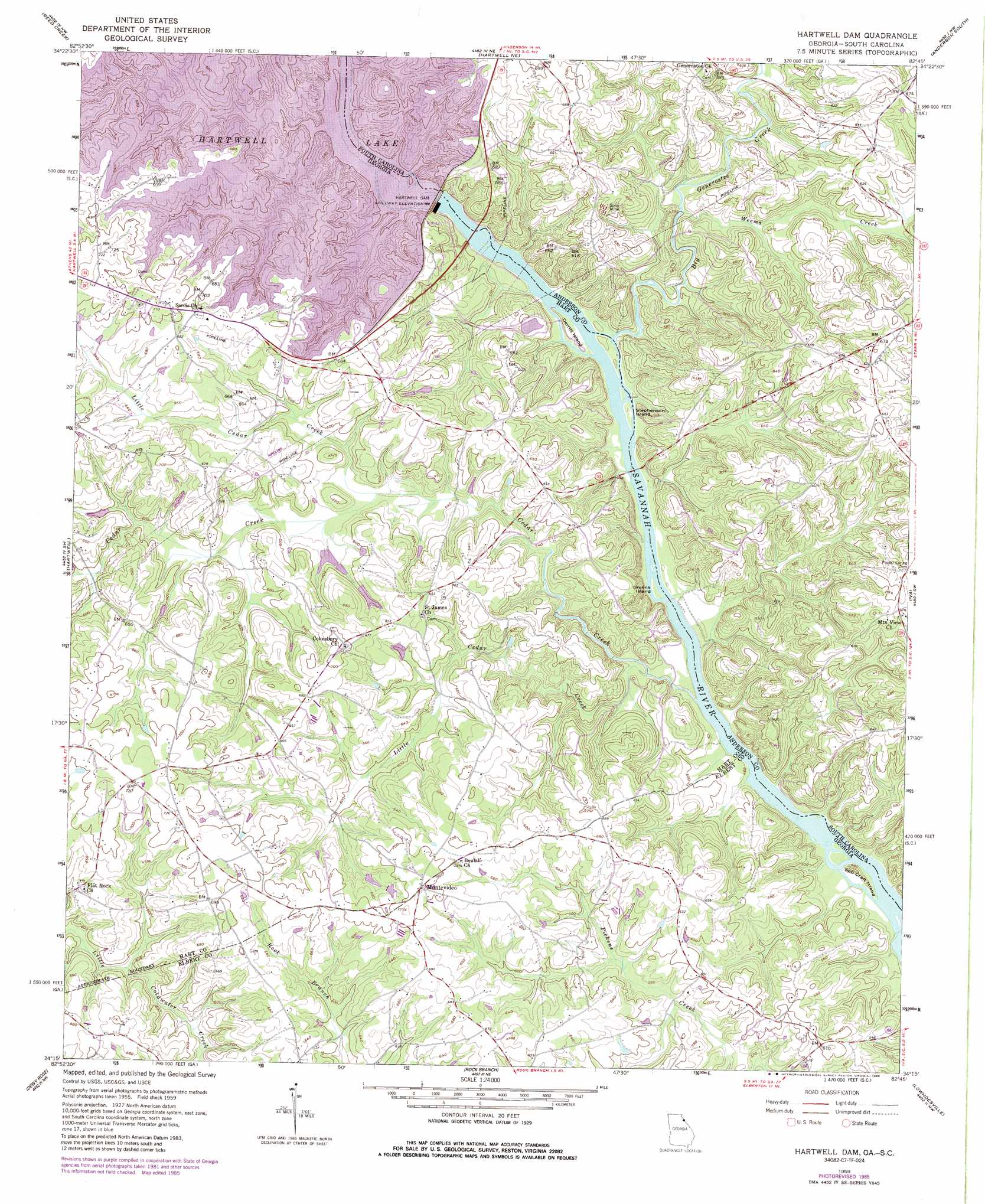
Hartwell Dam Topo Map Georgia
To zoom in, hover over the map of Hartwell Dam
USGS Topo Quad 34082c7 - 1:24,000 scale
| Topo Map Name: | Hartwell Dam |
| USGS Topo Quad ID: | 34082c7 |
| Print Size: | ca. 21 1/4" wide x 27" high |
| Southeast Coordinates: | 34.25° N latitude / 82.75° W longitude |
| Map Center Coordinates: | 34.3125° N latitude / 82.8125° W longitude |
| U.S. States: | GA, SC |
| Filename: | o34082c7.jpg |
| Download Map JPG Image: | Hartwell Dam topo map 1:24,000 scale |
| Map Type: | Topographic |
| Topo Series: | 7.5´ |
| Map Scale: | 1:24,000 |
| Source of Map Images: | United States Geological Survey (USGS) |
| Alternate Map Versions: |
Hartwell Dam GA 1959, updated 1961 Download PDF Buy paper map Hartwell Dam GA 1959, updated 1972 Download PDF Buy paper map Hartwell Dam GA 1959, updated 1975 Download PDF Buy paper map Hartwell Dam GA 1959, updated 1986 Download PDF Buy paper map Hartwell Dam GA 2011 Download PDF Buy paper map Hartwell Dam GA 2014 Download PDF Buy paper map |
1:24,000 Topo Quads surrounding Hartwell Dam
Oakway |
Fair Play |
La France |
Anderson North |
Belton West |
Lavonia |
Reed Creek |
Hartwell Ne |
Anderson South |
Saylors Crossroads |
Royston |
Hartwell |
Hartwell Dam |
Iva |
Antreville |
Bowman |
Dewy Rose |
Rock Branch |
Lowndesville |
Latimer |
Carlton |
Elberton West |
Elberton East |
Heardmont |
Calhoun Falls |
> Back to 34082a1 at 1:100,000 scale
> Back to 34082a1 at 1:250,000 scale
> Back to U.S. Topo Maps home
Hartwell Dam topo map: Gazetteer
Hartwell Dam: Bridges
Louis Morris Memorial Bridge elevation 146m 479′Louis Morris Memorial Bridge elevation 146m 479′
Smith-McGee Bridge elevation 140m 459′
Smith-McGee Bridge elevation 140m 459′
Hartwell Dam: Crossings
Dooleys Ferry (historical) elevation 201m 659′Dooleys Ferry (historical) elevation 201m 659′
Parks Ferry (historical) elevation 140m 459′
Parks Ferry (historical) elevation 140m 459′
Sadlers Ferry (historical) elevation 139m 456′
Sadlers Ferry (historical) elevation 139m 456′
Hartwell Dam: Dams
Cole Dam One elevation 174m 570′Cole Dam Three elevation 184m 603′
Cole Dam Two elevation 175m 574′
Hartwell Dam elevation 146m 479′
Hartwell Dam elevation 164m 538′
Hartwell Dam elevation 152m 498′
McLaughlin Lake Dam elevation 190m 623′
Hartwell Dam: Islands
Derritt Island elevation 146m 479′Greens Island elevation 141m 462′
Hewin Island elevation 145m 475′
Seb Craft Island elevation 134m 439′
Stephenson Island elevation 144m 472′
Hartwell Dam: Populated Places
Monteideo (historical) elevation 199m 652′Montevideo elevation 216m 708′
Hartwell Dam: Reservoirs
Cole Lake One elevation 174m 570′Cole Lake Three elevation 184m 603′
Cole Lake Two elevation 175m 574′
Hartwell Lake elevation 164m 538′
McLaughlin Lake elevation 190m 623′
Hartwell Dam: Streams
Big Generostee Creek elevation 143m 469′Byers Creek elevation 145m 475′
Cedar Creek elevation 137m 449′
Little Cedar Creek elevation 165m 541′
Little Cedar Creek elevation 137m 449′
Lucas Creek elevation 145m 475′
Weems Creek elevation 153m 501′
Hartwell Dam digital topo map on disk
Buy this Hartwell Dam topo map showing relief, roads, GPS coordinates and other geographical features, as a high-resolution digital map file on DVD:
South Carolina, Western North Carolina & Northeastern Georgia
Buy digital topo maps: South Carolina, Western North Carolina & Northeastern Georgia