Russell Lake Topo Map Georgia
To zoom in, hover over the map of Russell Lake
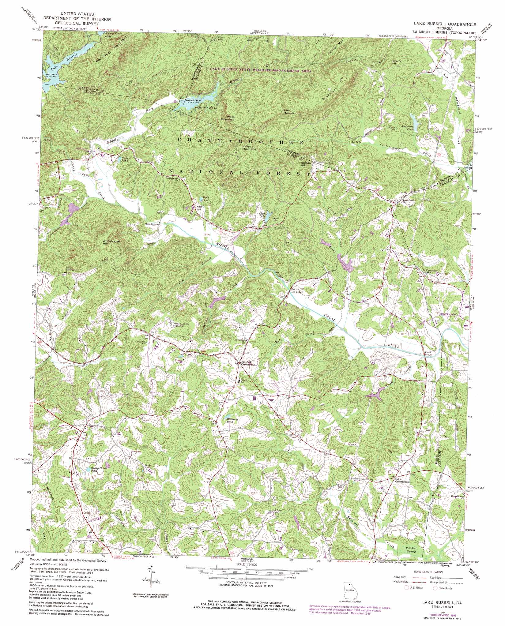
USGS Topo Quad 34083d4 - 1:24,000 scale
| Topo Map Name: | Russell Lake |
| USGS Topo Quad ID: | 34083d4 |
| Print Size: | ca. 21 1/4" wide x 27" high |
| Southeast Coordinates: | 34.375° N latitude / 83.375° W longitude |
| Map Center Coordinates: | 34.4375° N latitude / 83.4375° W longitude |
| U.S. State: | GA |
| Filename: | o34083d4.jpg |
| Download Map JPG Image: | Russell Lake topo map 1:24,000 scale |
| Map Type: | Topographic |
| Topo Series: | 7.5´ |
| Map Scale: | 1:24,000 |
| Source of Map Images: | United States Geological Survey (USGS) |
| Alternate Map Versions: |
Lake Russell GA 1964, updated 1965 Download PDF Buy paper map Lake Russell GA 1964, updated 1986 Download PDF Buy paper map Lake Russell GA 2011 Download PDF Buy paper map Lake Russell GA 2014 Download PDF Buy paper map |
| FStopo: | US Forest Service topo Lake Russell is available: Download FStopo PDF Download FStopo TIF |
1:24,000 Topo Quads surrounding Russell Lake
Helen |
Clarkesville Ne |
Tallulah Falls |
Tugaloo Lake |
Holly Springs |
Leaf |
Clarkesville |
Ayersville |
Toccoa |
Avalon |
Lula |
Baldwin |
Russell Lake |
Red Hill |
Martin |
Gillsville |
Maysville |
Homer |
Ashland |
Carnesville |
Pendergrass |
Apple Valley |
Commerce |
Ila |
Danielsville North |
> Back to 34083a1 at 1:100,000 scale
> Back to 34082a1 at 1:250,000 scale
> Back to U.S. Topo Maps home
Russell Lake topo map: Gazetteer
Russell Lake: Bars
Wofford Shoals elevation 227m 744′Russell Lake: Bridges
Brown Bridge elevation 213m 698′Hooper Bridge elevation 208m 682′
Kesler Bridge elevation 206m 675′
Line Bridge elevation 210m 688′
Moss Bridge elevation 219m 718′
Russell Lake: Dams
Anderson Pond Dam elevation 223m 731′Cash Lake Dam elevation 244m 800′
Dean Lake Dam elevation 237m 777′
Middle Fork Broad River Structure Six Dam elevation 232m 761′
Nancy Town Lake Dam elevation 314m 1030′
Russell Lake Dam elevation 302m 990′
Russell Lake: Populated Places
Nancytown (historical) elevation 230m 754′Odis Crossroads elevation 266m 872′
Pinefield Crossroads elevation 285m 935′
Prospect elevation 245m 803′
Pruitt elevation 278m 912′
Uvena elevation 245m 803′
Russell Lake: Reservoirs
Anderson Pond elevation 223m 731′Cash Lake elevation 244m 800′
Dean Lake elevation 237m 777′
Gailey Pond elevation 232m 761′
Irvin Pond elevation 233m 764′
Lake Russell elevation 302m 990′
Nancy Town Lake elevation 314m 1030′
Reservoir 17 elevation 220m 721′
Reservoir 28 elevation 216m 708′
Reservoir 30 elevation 219m 718′
Reservoir Number 44 elevation 231m 757′
Reservoir Number 46 elevation 219m 718′
Reservoir Six elevation 232m 761′
Shady Grove Pond elevation 294m 964′
Wilbanks Pond elevation 280m 918′
Russell Lake: Ridges
Soapstone Mountain elevation 386m 1266′Russell Lake: Streams
Big Leatherwood Creek elevation 216m 708′Brady Creek elevation 215m 705′
Bug Branch elevation 214m 702′
Cash Creek elevation 206m 675′
Lawson Creek elevation 216m 708′
Little Leatherwood Creek elevation 215m 705′
Mill Creek elevation 208m 682′
Nancy Town Creek elevation 219m 718′
Rocky Branch elevation 224m 734′
Rushie Branch elevation 234m 767′
Tates Creek elevation 207m 679′
Whitehouse Creek elevation 220m 721′
Russell Lake: Summits
Allen Mountain elevation 398m 1305′Brady Hill elevation 295m 967′
Farmer Mountain elevation 390m 1279′
Kelley Mountain elevation 372m 1220′
Norton Hill elevation 365m 1197′
Red Root Mountain elevation 408m 1338′
Wells Mountain elevation 355m 1164′
Whitehouse Hill elevation 361m 1184′
Russell Lake: Swamps
Pritchett Swamp elevation 229m 751′Russell Lake digital topo map on disk
Buy this Russell Lake topo map showing relief, roads, GPS coordinates and other geographical features, as a high-resolution digital map file on DVD:
South Carolina, Western North Carolina & Northeastern Georgia
Buy digital topo maps: South Carolina, Western North Carolina & Northeastern Georgia