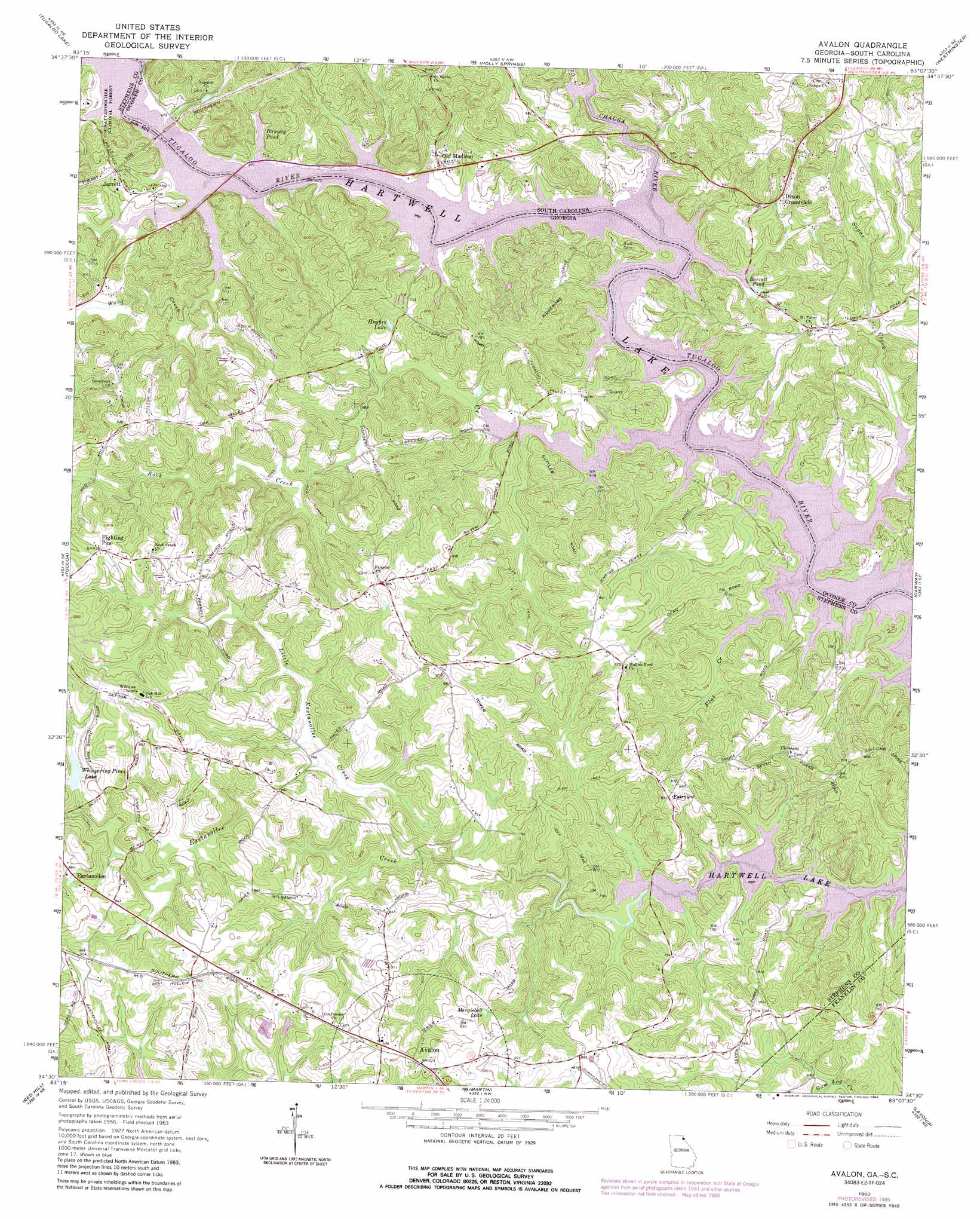
Avalon Topo Map Georgia
To zoom in, hover over the map of Avalon
USGS Topo Quad 34083e2 - 1:24,000 scale
| Topo Map Name: | Avalon |
| USGS Topo Quad ID: | 34083e2 |
| Print Size: | ca. 21 1/4" wide x 27" high |
| Southeast Coordinates: | 34.5° N latitude / 83.125° W longitude |
| Map Center Coordinates: | 34.5625° N latitude / 83.1875° W longitude |
| U.S. States: | GA, SC |
| Filename: | o34083e2.jpg |
| Download Map JPG Image: | Avalon topo map 1:24,000 scale |
| Map Type: | Topographic |
| Topo Series: | 7.5´ |
| Map Scale: | 1:24,000 |
| Source of Map Images: | United States Geological Survey (USGS) |
| Alternate Map Versions: |
Avalon GA 1963, updated 1964 Download PDF Buy paper map Avalon GA 1963, updated 1976 Download PDF Buy paper map Avalon GA 1963, updated 1986 Download PDF Buy paper map Avalon GA 2011 Download PDF Buy paper map Avalon GA 2014 Download PDF Buy paper map |
| FStopo: | US Forest Service topo Avalon is available: Download FStopo PDF Download FStopo TIF |
1:24,000 Topo Quads surrounding Avalon
Tiger |
Rainy Mountain |
Whetstone |
Walhalla |
Old Pickens |
Tallulah Falls |
Tugaloo Lake |
Holly Springs |
Westminster |
Seneca |
Ayersville |
Toccoa |
Avalon |
Oakway |
Fair Play |
Russell Lake |
Red Hill |
Martin |
Lavonia |
Reed Creek |
Homer |
Ashland |
Carnesville |
Royston |
Hartwell |
> Back to 34083e1 at 1:100,000 scale
> Back to 34082a1 at 1:250,000 scale
> Back to U.S. Topo Maps home
Avalon topo map: Gazetteer
Avalon: Bars
Cleveland Shoal (historical) elevation 201m 659′Cleveland Shoal (historical) elevation 201m 659′
Avalon: Bridges
Jarrett Bridge (historical) elevation 201m 659′Jarrett Bridge (historical) elevation 201m 659′
Ramsey-Jarrett Bridge elevation 201m 659′
Ramsey-Jarrett Bridge elevation 201m 659′
Avalon: Crossings
Jenkins Ferry (historical) elevation 201m 659′Jenkins Ferry (historical) elevation 201m 659′
Mullens Ford (historical) elevation 201m 659′
Mullens Ford (historical) elevation 201m 659′
Ramsey Ferry (historical) elevation 201m 659′
Ramsey Ferry (historical) elevation 201m 659′
Waltons Ford (historical) elevation 201m 659′
Waltons Ford (historical) elevation 201m 659′
Avalon: Parks
Colonel Cleveland Monument elevation 220m 721′Avalon: Populated Places
Avalon elevation 281m 921′Dixon Crossroads elevation 232m 761′
Fairview elevation 252m 826′
Fighting Pine elevation 285m 935′
Jarrett elevation 218m 715′
Old Madison elevation 215m 705′
Tabor elevation 233m 764′
Avalon: Reservoirs
Barrett Pond elevation 205m 672′Hughes Lake elevation 219m 718′
Margiebell Lake elevation 263m 862′
Ramsey Pond elevation 204m 669′
Whispering Pines Lake elevation 257m 843′
Avalon: Streams
Chauga River elevation 201m 659′Eastanollee Creek elevation 205m 672′
Flat Creek elevation 205m 672′
Little Eastanollee Creek elevation 213m 698′
Rock Creek elevation 201m 659′
Sugar Creek elevation 201m 659′
Walton Creek elevation 201m 659′
Wards Creek elevation 201m 659′
Avalon digital topo map on disk
Buy this Avalon topo map showing relief, roads, GPS coordinates and other geographical features, as a high-resolution digital map file on DVD:
South Carolina, Western North Carolina & Northeastern Georgia
Buy digital topo maps: South Carolina, Western North Carolina & Northeastern Georgia