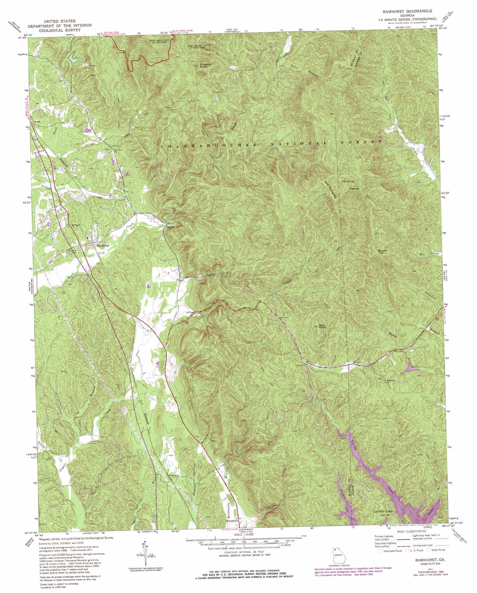
Ramhurst Topo Map Georgia
To zoom in, hover over the map of Ramhurst
USGS Topo Quad 34084f6 - 1:24,000 scale
| Topo Map Name: | Ramhurst |
| USGS Topo Quad ID: | 34084f6 |
| Print Size: | ca. 21 1/4" wide x 27" high |
| Southeast Coordinates: | 34.625° N latitude / 84.625° W longitude |
| Map Center Coordinates: | 34.6875° N latitude / 84.6875° W longitude |
| U.S. State: | GA |
| Filename: | o34084f6.jpg |
| Download Map JPG Image: | Ramhurst topo map 1:24,000 scale |
| Map Type: | Topographic |
| Topo Series: | 7.5´ |
| Map Scale: | 1:24,000 |
| Source of Map Images: | United States Geological Survey (USGS) |
| Alternate Map Versions: |
Ramhurst GA 1971, updated 1974 Download PDF Buy paper map Ramhurst GA 1971, updated 1986 Download PDF Buy paper map Ramhurst GA 2011 Download PDF Buy paper map Ramhurst GA 2014 Download PDF Buy paper map |
| FStopo: | US Forest Service topo Ramhurst is available: Download FStopo PDF Download FStopo TIF |
1:24,000 Topo Quads surrounding Ramhurst
Cohutta |
Beaverdale |
Tennga |
Hemp Top |
Epworth |
Dalton North |
Chatsworth |
Crandall |
Dyer Gap |
Cashes Valley |
Dalton South |
Calhoun Ne |
Ramhurst |
Webb |
Ellijay |
Calhoun North |
Redbud |
Oakman |
Talking Rock |
Dyke |
Calhoun South |
Sonoraville |
Fairmount |
Ludville |
Jasper |
> Back to 34084e1 at 1:100,000 scale
> Back to 34084a1 at 1:250,000 scale
> Back to U.S. Topo Maps home
Ramhurst topo map: Gazetteer
Ramhurst: Bridges
Hill Wilbanks Memorial Bridge elevation 220m 721′Ramhurst: Dams
Glenn Lake Dam elevation 305m 1000′Miller-Grindley Pond Dam elevation 403m 1322′
Mountaintown Creek Watershed Dam Number Four elevation 481m 1578′
Reed Lake Dam elevation 246m 807′
Ramhurst: Mines
Bramlet Mine elevation 553m 1814′Georgia Mine elevation 335m 1099′
Old Cohutta Mine elevation 303m 994′
Pickering Mine elevation 337m 1105′
Ramhurst: Populated Places
Bloodtown elevation 212m 695′Coniston elevation 214m 702′
Dennis elevation 245m 803′
Ramhurst elevation 238m 780′
Ramhurst: Post Offices
Ramhurst Post Office (historical) elevation 238m 780′Ramhurst: Reservoirs
Corbin Lake elevation 481m 1578′Glenn Lake elevation 305m 1000′
Miller-Grindley Pond elevation 403m 1322′
Reed Lake elevation 246m 807′
Ramhurst: Springs
Cold Spring elevation 715m 2345′Ramhurst: Streams
Baker Branch elevation 454m 1489′Bearpen Branch elevation 454m 1489′
Duck Branch elevation 220m 721′
Falls Branch elevation 442m 1450′
Little Sugar Creek elevation 198m 649′
Long Branch elevation 201m 659′
Ramhurst: Summits
Brushy Top elevation 731m 2398′Buck Knob elevation 510m 1673′
Chestnut Knob elevation 677m 2221′
Cold Spring Mountain elevation 809m 2654′
Hightop elevation 816m 2677′
Ramhurst digital topo map on disk
Buy this Ramhurst topo map showing relief, roads, GPS coordinates and other geographical features, as a high-resolution digital map file on DVD: