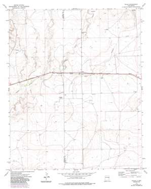
Tolar Topo Map New Mexico
To zoom in, hover over the map of Tolar
USGS Topo Quad 34103d8 - 1:24,000 scale
| Topo Map Name: | Tolar |
| USGS Topo Quad ID: | 34103d8 |
| Print Size: | ca. 21 1/4" wide x 27" high |
| Southeast Coordinates: | 34.375° N latitude / 103.875° W longitude |
| Map Center Coordinates: | 34.4375° N latitude / 103.9375° W longitude |
| U.S. State: | NM |
| Filename: | o34103d8.jpg |
| Download Map JPG Image: | Tolar topo map 1:24,000 scale |
| Map Type: | Topographic |
| Topo Series: | 7.5´ |
| Map Scale: | 1:24,000 |
| Source of Map Images: | United States Geological Survey (USGS) |
| Alternate Map Versions: |
Tolar NM 1973, updated 1975 Download PDF Buy paper map Tolar NM 1973, updated 1987 Download PDF Buy paper map Tolar NM 2010 Download PDF Buy paper map Tolar NM 2013 Download PDF Buy paper map Tolar NM 2017 Download PDF Buy paper map |
1:24,000 Topo Quads surrounding Tolar
> Back to 34103a1 at 1:100,000 scale
> Back to 34102a1 at 1:250,000 scale
> Back to U.S. Topo Maps home
Tolar topo map: Gazetteer
Tolar: Populated Places
Tolar elevation 1287m 4222′Tolar: Post Offices
Tolar Post Office (historical) elevation 1287m 4222′Tolar: Springs
Stinking Spring elevation 1271m 4169′Tolar: Streams
Alamosa Creek elevation 1265m 4150′Painter Jim Creek elevation 1258m 4127′
Sand Creek elevation 1265m 4150′
Tolar: Valleys
Long Canyon elevation 1256m 4120′Tolar: Wells
Gaddy Well elevation 1307m 4288′Russell Well elevation 1302m 4271′
Tolar digital topo map on disk
Buy this Tolar topo map showing relief, roads, GPS coordinates and other geographical features, as a high-resolution digital map file on DVD:


