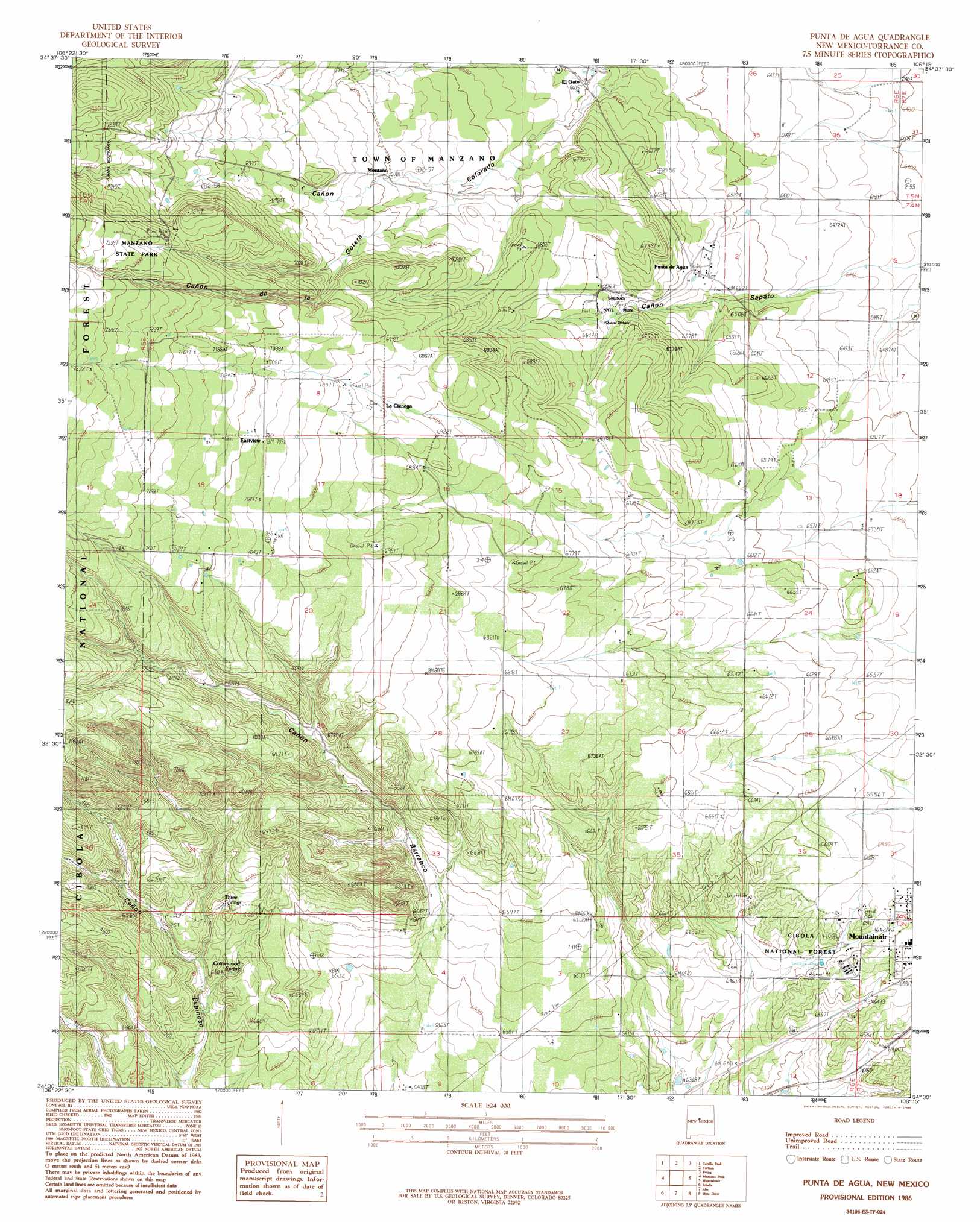
Punta De Agua Topo Map New Mexico
To zoom in, hover over the map of Punta De Agua
USGS Topo Quad 34106e3 - 1:24,000 scale
| Topo Map Name: | Punta De Agua |
| USGS Topo Quad ID: | 34106e3 |
| Print Size: | ca. 21 1/4" wide x 27" high |
| Southeast Coordinates: | 34.5° N latitude / 106.25° W longitude |
| Map Center Coordinates: | 34.5625° N latitude / 106.3125° W longitude |
| U.S. State: | NM |
| Filename: | o34106e3.jpg |
| Download Map JPG Image: | Punta De Agua topo map 1:24,000 scale |
| Map Type: | Topographic |
| Topo Series: | 7.5´ |
| Map Scale: | 1:24,000 |
| Source of Map Images: | United States Geological Survey (USGS) |
| Alternate Map Versions: |
Punta De Agua NM 1986, updated 1986 Download PDF Buy paper map Punta De Agua NM 1995, updated 1998 Download PDF Buy paper map Punta de Agua NM 2011 Download PDF Buy paper map Punta de Agua NM 2013 Download PDF Buy paper map Punta de Agua NM 2017 Download PDF Buy paper map |
| FStopo: | US Forest Service topo Punta de Agua is available: Download FStopo PDF Download FStopo TIF |
1:24,000 Topo Quads surrounding Punta De Agua
Los Lunas Se |
Bosque Peak |
Tajique |
Milbourn Ranch |
Estancia |
Tome Ne |
Capilla Peak |
Torreon |
Ewing |
Mountainair Ne |
Tome Se |
Manzano Peak |
Punta De Agua |
Mountainair |
Willard |
Becker |
Scholle |
Abo |
Mesa Draw |
Round Top |
Cerro Montoso |
Rayo Hills |
Chupadera |
Bigbee Draw |
Gran Quivira |
> Back to 34106e1 at 1:100,000 scale
> Back to 34106a1 at 1:250,000 scale
> Back to U.S. Topo Maps home
Punta De Agua topo map: Gazetteer
Punta De Agua: Parks
Gran Quivira Ruins National Monument Historical Marker elevation 2021m 6630′Manzano State Park elevation 2216m 7270′
Quarai Ruins Salinas National Monument Historical Marker elevation 2021m 6630′
Ranger Station Picnic Ground elevation 1977m 6486′
Salinas National Monument elevation 2021m 6630′
Salinas National Monument Historical Marker elevation 2021m 6630′
Punta De Agua: Populated Places
D Candelaria Ranch elevation 2172m 7125′El Gato elevation 2012m 6601′
Hewitt Place elevation 2147m 7043′
La Cienega elevation 2123m 6965′
Los Chavez elevation 2107m 6912′
Martin Place elevation 2044m 6706′
Punta de Agua elevation 2004m 6574′
Punta De Agua: Post Offices
Punta De Agua Post Office (historical) elevation 2004m 6574′Quarai Post Office elevation 2021m 6630′
Punta De Agua: Springs
Cottonwood Spring elevation 1978m 6489′Three Springs elevation 2005m 6578′
Punta De Agua: Summits
Cerrito del Espia elevation 2216m 7270′Punta De Agua: Valleys
Cañon de la Gotera elevation 2042m 6699′Cañon Sapato elevation 1968m 6456′
Punta De Agua: Wells
10221 Water Well elevation 2029m 6656′Fain Well elevation 1994m 6541′
Kayser Well elevation 2233m 7326′
Punta De Agua digital topo map on disk
Buy this Punta De Agua topo map showing relief, roads, GPS coordinates and other geographical features, as a high-resolution digital map file on DVD: