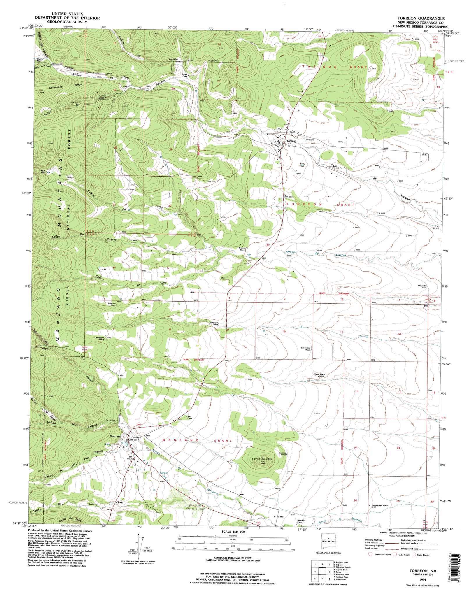
Torreon Topo Map New Mexico
To zoom in, hover over the map of Torreon
USGS Topo Quad 34106f3 - 1:24,000 scale
| Topo Map Name: | Torreon |
| USGS Topo Quad ID: | 34106f3 |
| Print Size: | ca. 21 1/4" wide x 27" high |
| Southeast Coordinates: | 34.625° N latitude / 106.25° W longitude |
| Map Center Coordinates: | 34.6875° N latitude / 106.3125° W longitude |
| U.S. State: | NM |
| Filename: | o34106f3.jpg |
| Download Map JPG Image: | Torreon topo map 1:24,000 scale |
| Map Type: | Topographic |
| Topo Series: | 7.5´ |
| Map Scale: | 1:24,000 |
| Source of Map Images: | United States Geological Survey (USGS) |
| Alternate Map Versions: |
Torreon NM 1954, updated 1955 Download PDF Buy paper map Torreon NM 1954, updated 1993 Download PDF Buy paper map Torreon NM 1991, updated 1995 Download PDF Buy paper map Torreon NM 2011 Download PDF Buy paper map Torreon NM 2013 Download PDF Buy paper map Torreon NM 2017 Download PDF Buy paper map |
| FStopo: | US Forest Service topo Torreon is available: Download FStopo PDF Download FStopo TIF |
1:24,000 Topo Quads surrounding Torreon
Hubbell Spring |
Mount Washington |
Escabosa |
Chilili |
Moriarty South |
Los Lunas Se |
Bosque Peak |
Tajique |
Milbourn Ranch |
Estancia |
Tome Ne |
Capilla Peak |
Torreon |
Ewing |
Mountainair Ne |
Tome Se |
Manzano Peak |
Punta De Agua |
Mountainair |
Willard |
Becker |
Scholle |
Abo |
Mesa Draw |
Round Top |
> Back to 34106e1 at 1:100,000 scale
> Back to 34106a1 at 1:250,000 scale
> Back to U.S. Topo Maps home
Torreon topo map: Gazetteer
Torreon: Populated Places
Alexander Place elevation 1994m 6541′Anderson Place elevation 2155m 7070′
Benson Place elevation 2048m 6719′
Bermadez Place elevation 2068m 6784′
Brizendine Place elevation 2032m 6666′
Brown Place elevation 2114m 6935′
Candelaria Place elevation 2166m 7106′
Chato elevation 2104m 6902′
Hyde Place elevation 2222m 7290′
Maez Place elevation 2015m 6610′
Manzano elevation 2091m 6860′
Moorehead Place elevation 1971m 6466′
Romero Place elevation 2028m 6653′
Saiz Place elevation 2085m 6840′
Sanchez Place elevation 1995m 6545′
Torreon elevation 2042m 6699′
Torreon: Post Offices
Manzano Post Office (historical) elevation 2091m 6860′Torreon Post Office elevation 2042m 6699′
Torreon: Ridges
Comanche Ridge elevation 2150m 7053′Torreon: Springs
Ojo Medio elevation 2188m 7178′Torreon Spring elevation 2044m 6706′
Torreon: Summits
Cerrito del Llano elevation 2088m 6850′Torreon: Valleys
Cañon Colorado elevation 2006m 6581′Cañon de Bartolo elevation 2102m 6896′
Cañon de Cuervo elevation 2102m 6896′
Cañon de la Capilla elevation 2147m 7043′
Cañon de la Vereda elevation 2207m 7240′
Cañon de las Palas elevation 2149m 7050′
Cañon de los Pino Reales elevation 2103m 6899′
Cañon de Novillo elevation 2122m 6961′
Cañon de Torreon elevation 2234m 7329′
Cañon del Agua elevation 2091m 6860′
Cañon del Chato elevation 2102m 6896′
Cañon del Encierro elevation 2191m 7188′
Cañon del Jaral elevation 2097m 6879′
Cañon del Venado elevation 2209m 7247′
Cañon Nuevo elevation 2102m 6896′
Torreon digital topo map on disk
Buy this Torreon topo map showing relief, roads, GPS coordinates and other geographical features, as a high-resolution digital map file on DVD: