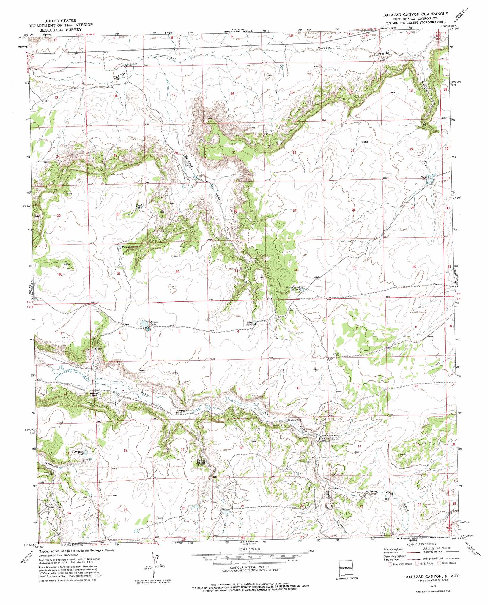
Salazar Canyon Topo Map New Mexico
To zoom in, hover over the map of Salazar Canyon
USGS Topo Quad 34108d8 - 1:24,000 scale
| Topo Map Name: | Salazar Canyon |
| USGS Topo Quad ID: | 34108d8 |
| Print Size: | ca. 21 1/4" wide x 27" high |
| Southeast Coordinates: | 34.375° N latitude / 108.875° W longitude |
| Map Center Coordinates: | 34.4375° N latitude / 108.9375° W longitude |
| U.S. State: | NM |
| Filename: | o34108d8.jpg |
| Download Map JPG Image: | Salazar Canyon topo map 1:24,000 scale |
| Map Type: | Topographic |
| Topo Series: | 7.5´ |
| Map Scale: | 1:24,000 |
| Source of Map Images: | United States Geological Survey (USGS) |
| Alternate Map Versions: |
Salazar Canyon NM 1972, updated 1976 Download PDF Buy paper map Salazar Canyon NM 2010 Download PDF Buy paper map Salazar Canyon NM 2013 Download PDF Buy paper map Salazar Canyon NM 2017 Download PDF Buy paper map |
1:24,000 Topo Quads surrounding Salazar Canyon
Valle Bonito |
Valle Bonito Ne |
Cantaralo Spring |
Rincon Hondo |
Fence Lake |
Kearn Lake |
Carrisito Spring |
Twentytwo Spring |
Moreno Hill |
Fence Lake Sw |
Mesa Parada Nw |
Mesa Parada |
Salazar Canyon |
Zuni Salt Lake |
Lake Armijo |
Voigt Ranch |
The Rincon |
Goat Spring |
Blaines Lake |
Tejana Mesa Sw |
Coyote Hills |
Nelson Reservoir Ne |
Cow Springs |
Red Hill |
Pondersoa Tank |
> Back to 34108a1 at 1:100,000 scale
> Back to 34108a1 at 1:250,000 scale
> Back to U.S. Topo Maps home
Salazar Canyon topo map: Gazetteer
Salazar Canyon: Dams
Goat Detention Dam One elevation 1997m 6551′Goat Detention Dam Two elevation 1997m 6551′
Salazar Canyon: Reservoirs
Burr Tank elevation 1994m 6541′Jercka Lake elevation 2000m 6561′
Rim Tank elevation 1995m 6545′
Rock Pit elevation 1973m 6473′
South Mesa Tank elevation 2004m 6574′
Trail Tank elevation 1976m 6482′
Wire Corral Tank elevation 2022m 6633′
Salazar Canyon: Streams
Agua Fria Creek elevation 1976m 6482′Salazar Canyon: Valleys
Cañon de Juei elevation 1893m 6210′Red Hill Draw elevation 1970m 6463′
Salazar Canyon elevation 1864m 6115′
Salazar Canyon: Wells
Allen Well elevation 1861m 6105′Dipping Vat Well elevation 1954m 6410′
Pipeline Well elevation 1967m 6453′
Rock House Wells elevation 1975m 6479′
Salazar Canyon digital topo map on disk
Buy this Salazar Canyon topo map showing relief, roads, GPS coordinates and other geographical features, as a high-resolution digital map file on DVD: