Zuni Salt Lake Topo Map New Mexico
To zoom in, hover over the map of Zuni Salt Lake
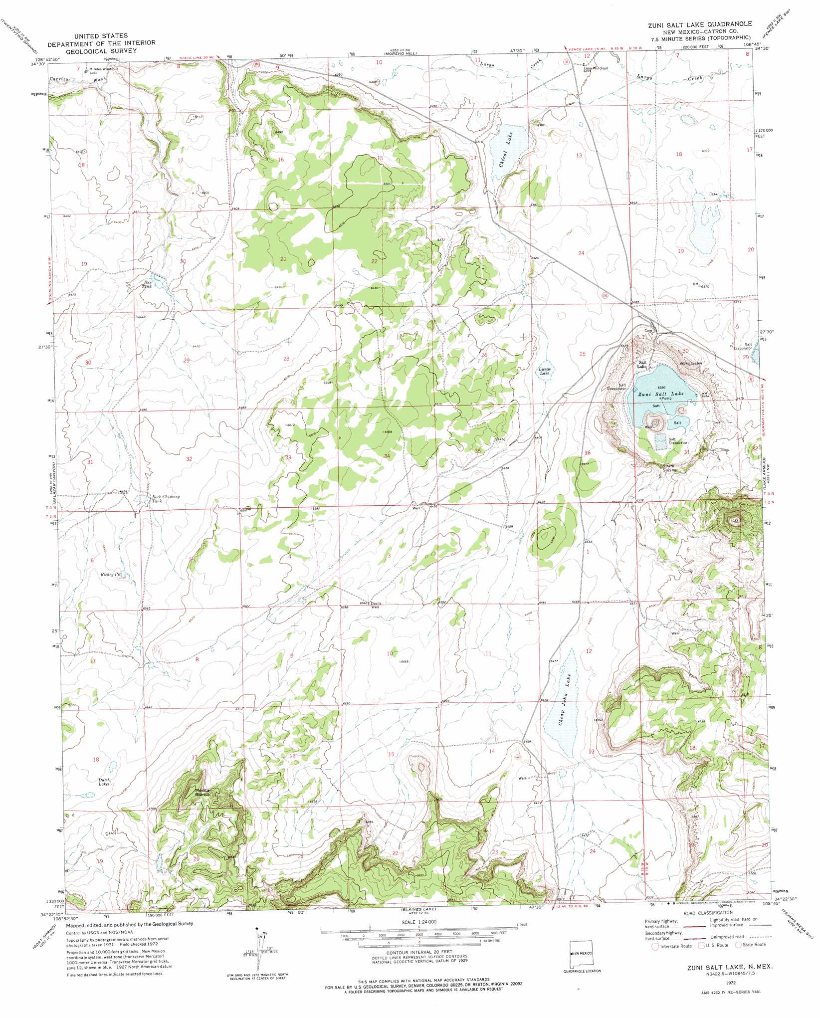
USGS Topo Quad 34108d7 - 1:24,000 scale
| Topo Map Name: | Zuni Salt Lake |
| USGS Topo Quad ID: | 34108d7 |
| Print Size: | ca. 21 1/4" wide x 27" high |
| Southeast Coordinates: | 34.375° N latitude / 108.75° W longitude |
| Map Center Coordinates: | 34.4375° N latitude / 108.8125° W longitude |
| U.S. State: | NM |
| Filename: | o34108d7.jpg |
| Download Map JPG Image: | Zuni Salt Lake topo map 1:24,000 scale |
| Map Type: | Topographic |
| Topo Series: | 7.5´ |
| Map Scale: | 1:24,000 |
| Source of Map Images: | United States Geological Survey (USGS) |
| Alternate Map Versions: |
Zuni Salt Lake NM 1972, updated 1976 Download PDF Buy paper map Zuni Salt Lake NM 2010 Download PDF Buy paper map Zuni Salt Lake NM 2013 Download PDF Buy paper map Zuni Salt Lake NM 2017 Download PDF Buy paper map |
1:24,000 Topo Quads surrounding Zuni Salt Lake
Valle Bonito Ne |
Cantaralo Spring |
Rincon Hondo |
Fence Lake |
The Dyke |
Carrisito Spring |
Twentytwo Spring |
Moreno Hill |
Fence Lake Sw |
Cerro Prieto |
Mesa Parada |
Salazar Canyon |
Zuni Salt Lake |
Lake Armijo |
Tejana Mesa |
The Rincon |
Goat Spring |
Blaines Lake |
Tejana Mesa Sw |
Armstrong Canyon |
Nelson Reservoir Ne |
Cow Springs |
Red Hill |
Pondersoa Tank |
Largo Mesa |
> Back to 34108a1 at 1:100,000 scale
> Back to 34108a1 at 1:250,000 scale
> Back to U.S. Topo Maps home
Zuni Salt Lake topo map: Gazetteer
Zuni Salt Lake: Lakes
Dutch Lakes elevation 2037m 6683′Zuñi Salt Lake elevation 1897m 6223′
Zuni Salt Lake: Mines
Zuñi Salt Lake Mine elevation 1903m 6243′Zuni Salt Lake: Parks
Mesita Blanca Wilderness Study Area elevation 2137m 7011′Zuni Salt Lake: Populated Places
Salt Lake elevation 1900m 6233′Zuni Salt Lake: Post Offices
Salt Lake Post Office (historical) elevation 1900m 6233′Zuni Salt Lake: Reservoirs
Cheap John Lake elevation 1970m 6463′Chical Lake elevation 1919m 6295′
Ikes Tank elevation 1946m 6384′
Lunas Lake elevation 1942m 6371′
Richey Pit elevation 1994m 6541′
Rock Chimney Tank elevation 1981m 6499′
Zuni Salt Lake: Summits
Mesita Blanca elevation 2137m 7011′Zuni Salt Lake: Valleys
Cottonwood Canyon elevation 1970m 6463′Zuni Salt Lake: Wells
Davila Well elevation 2001m 6564′Layton Number 3 Water Well elevation 2007m 6584′
Layton Number 4 Water Well elevation 1993m 6538′
Zuni Salt Lake digital topo map on disk
Buy this Zuni Salt Lake topo map showing relief, roads, GPS coordinates and other geographical features, as a high-resolution digital map file on DVD: