Southmont Topo Map North Carolina
To zoom in, hover over the map of Southmont
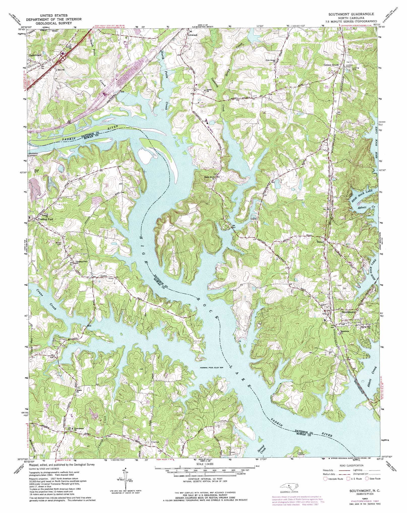
USGS Topo Quad 35080f3 - 1:24,000 scale
| Topo Map Name: | Southmont |
| USGS Topo Quad ID: | 35080f3 |
| Print Size: | ca. 21 1/4" wide x 27" high |
| Southeast Coordinates: | 35.625° N latitude / 80.25° W longitude |
| Map Center Coordinates: | 35.6875° N latitude / 80.3125° W longitude |
| U.S. State: | NC |
| Filename: | o35080f3.jpg |
| Download Map JPG Image: | Southmont topo map 1:24,000 scale |
| Map Type: | Topographic |
| Topo Series: | 7.5´ |
| Map Scale: | 1:24,000 |
| Source of Map Images: | United States Geological Survey (USGS) |
| Alternate Map Versions: |
Southmont NC 1962, updated 1964 Download PDF Buy paper map Southmont NC 1962, updated 1979 Download PDF Buy paper map Southmont NC 1962, updated 1987 Download PDF Buy paper map Southmont NC 2010 Download PDF Buy paper map Southmont NC 2013 Download PDF Buy paper map Southmont NC 2016 Download PDF Buy paper map |
1:24,000 Topo Quads surrounding Southmont
Mocksville |
Advance |
Welcome |
Midway |
High Point West |
Cooleemee |
Churchland |
Lexington West |
Lexington East |
Fair Grove |
Rowan Mills |
Salisbury |
Southmont |
Denton Nw |
Denton |
China Grove |
Rockwell |
Gold Hill |
High Rock |
Handy |
Concord |
Mount Pleasant |
Richfield |
New London |
Badin |
> Back to 35080e1 at 1:100,000 scale
> Back to 35080a1 at 1:250,000 scale
> Back to U.S. Topo Maps home
Southmont topo map: Gazetteer
Southmont: Crossings
Trading Ford (historical) elevation 190m 623′Southmont: Dams
Buck Ash Pond Dam elevation 201m 659′Clodfelter Lake Dam elevation 197m 646′
Cobles Reservoir Dam elevation 206m 675′
Dan Nicholas Lake Dam elevation 200m 656′
Southmont: Parks
Dan Nicholas Park elevation 190m 623′Southmont: Populated Places
Cotton Grove elevation 225m 738′Cowans Ferry elevation 224m 734′
Craven elevation 222m 728′
Feezor elevation 226m 741′
Foxcroff elevation 206m 675′
Jersey elevation 213m 698′
Lakeview elevation 233m 764′
Mountain View Estates elevation 217m 711′
Ravenwood elevation 218m 715′
Southmont elevation 207m 679′
Trading Ford elevation 224m 734′
Watership Downs elevation 194m 636′
Southmont: Reservoirs
Buck Ash Pond elevation 201m 659′Clodfelter Lake elevation 197m 646′
Cobles Reservoir elevation 206m 675′
Dan Nicholas Lake elevation 200m 656′
Southmont: Streams
Abbotts Creek elevation 188m 616′Church Creek elevation 189m 620′
Crane Creek elevation 189m 620′
North Potts Creek elevation 190m 623′
Second Creek elevation 189m 620′
Sooky Creek elevation 193m 633′
South Potts Creek elevation 189m 620′
Swearing Creek elevation 189m 620′
Southmont digital topo map on disk
Buy this Southmont topo map showing relief, roads, GPS coordinates and other geographical features, as a high-resolution digital map file on DVD:
South Carolina, Western North Carolina & Northeastern Georgia
Buy digital topo maps: South Carolina, Western North Carolina & Northeastern Georgia