Isabella Topo Map Tennessee
To zoom in, hover over the map of Isabella
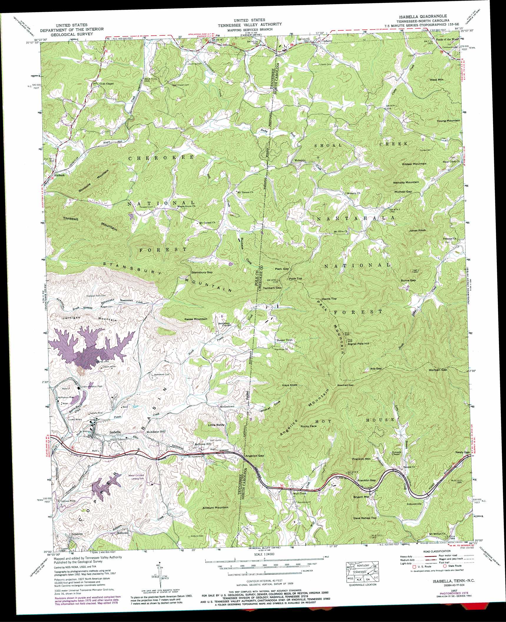
USGS Topo Quad 35084a3 - 1:24,000 scale
| Topo Map Name: | Isabella |
| USGS Topo Quad ID: | 35084a3 |
| Print Size: | ca. 21 1/4" wide x 27" high |
| Southeast Coordinates: | 35° N latitude / 84.25° W longitude |
| Map Center Coordinates: | 35.0625° N latitude / 84.3125° W longitude |
| U.S. States: | TN, NC |
| Filename: | o35084a3.jpg |
| Download Map JPG Image: | Isabella topo map 1:24,000 scale |
| Map Type: | Topographic |
| Topo Series: | 7.5´ |
| Map Scale: | 1:24,000 |
| Source of Map Images: | United States Geological Survey (USGS) |
| Alternate Map Versions: |
Isabella TN 1936 Download PDF Buy paper map Isabella TN 1957, updated 1959 Download PDF Buy paper map Isabella TN 1957, updated 1971 Download PDF Buy paper map Isabella TN 1957, updated 1978 Download PDF Buy paper map Isabella TN 1957, updated 1988 Download PDF Buy paper map Isabella TN 2011 Download PDF Buy paper map Isabella TN 2013 Download PDF Buy paper map Isabella TN 2016 Download PDF Buy paper map |
| FStopo: | US Forest Service topo Isabella is available: Download FStopo PDF Download FStopo TIF |
1:24,000 Topo Quads surrounding Isabella
Etowah |
Mecca |
Tellico Plains |
Bald River Falls |
Big Junction |
Oswald Dome |
Mcfarland |
Farner |
Unaka |
Mcdaniel Bald |
Caney Creek |
Ducktown |
Isabella |
Persimmon Creek |
Murphy |
Hemp Top |
Epworth |
Mineral Bluff |
Culberson |
Nottely Dam |
Dyer Gap |
Cashes Valley |
Blue Ridge |
Wilscot |
Mulky Gap |
> Back to 35084a1 at 1:100,000 scale
> Back to 35084a1 at 1:250,000 scale
> Back to U.S. Topo Maps home
Isabella topo map: Gazetteer
Isabella: Airports
Martin Campbell Field elevation 550m 1804′Isabella: Dams
Cities Services Dam elevation 512m 1679′City Services Retention Dam elevation 512m 1679′
Gypsum Dam elevation 489m 1604′
London Mills Tailings Pond Dam elevation 501m 1643′
Isabella: Gaps
Angelico Gap elevation 605m 1984′Arp Gap elevation 840m 2755′
Bowman Gap elevation 970m 3182′
Burns Gap elevation 658m 2158′
Franklin Gap elevation 658m 2158′
Michael Gap elevation 592m 1942′
Pack Gap elevation 632m 2073′
Stansbury Gap elevation 613m 2011′
Tanbark Gap elevation 650m 2132′
Wolfpen Gap elevation 856m 2808′
Isabella: Mines
Calloway Mines elevation 470m 1541′Eureka Mine elevation 499m 1637′
Isabella Mine elevation 499m 1637′
McPherson Mine elevation 497m 1630′
Isabella: Populated Places
Belltown elevation 474m 1555′Belltown Hill elevation 551m 1807′
Boonville (historical) elevation 526m 1725′
Burger Town elevation 592m 1942′
Coletown elevation 466m 1528′
Fields of the Wood elevation 498m 1633′
Harbuck elevation 501m 1643′
Isabella elevation 492m 1614′
Johnsonville elevation 571m 1873′
Kimsey elevation 497m 1630′
Liberty elevation 506m 1660′
McAllister Hill elevation 521m 1709′
McGeetown elevation 512m 1679′
Reesetown elevation 524m 1719′
Stewardtown (historical) elevation 512m 1679′
Wehutty elevation 490m 1607′
Wolf Creek elevation 576m 1889′
Isabella: Reservoirs
City Services Rention Pond elevation 512m 1679′Gypsum Pond elevation 489m 1604′
London Mills Tailings Pond elevation 501m 1643′
Isabella: Streams
Burra-Burra Creek elevation 485m 1591′Ellis Branch elevation 486m 1594′
Hall Creek elevation 478m 1568′
Long Branch elevation 577m 1893′
Negro Creek elevation 459m 1505′
Rocky Ford Creek elevation 472m 1548′
Isabella: Summits
Amburn Mountain elevation 718m 2355′Angelico Mountain elevation 1024m 3359′
Bryant Mountain elevation 753m 2470′
Dave Bellew Top elevation 733m 2404′
Franklin Mountain elevation 818m 2683′
Harris Top elevation 854m 2801′
Hays Knob elevation 762m 2500′
Jarnigan Mountain elevation 575m 1886′
Jones Knob elevation 733m 2404′
Kildeer Mountain elevation 759m 2490′
Little Baldy elevation 659m 2162′
Pack Mountain elevation 1043m 3421′
Pack Top elevation 735m 2411′
Reese Mountain elevation 679m 2227′
Rocky Face elevation 855m 2805′
Shinbone Mountain elevation 687m 2253′
Signal Pole Hill elevation 1051m 3448′
Stansbury Mountain elevation 684m 2244′
Threewit Mountain elevation 673m 2208′
Wehutty Mountain elevation 718m 2355′
West Mountain elevation 621m 2037′
Young Mountain elevation 651m 2135′
Isabella: Valleys
Buckeye Cove elevation 501m 1643′Buckeye Cove elevation 497m 1630′
Wildcat Cove elevation 523m 1715′
Wildcat Cove elevation 505m 1656′
Isabella digital topo map on disk
Buy this Isabella topo map showing relief, roads, GPS coordinates and other geographical features, as a high-resolution digital map file on DVD: