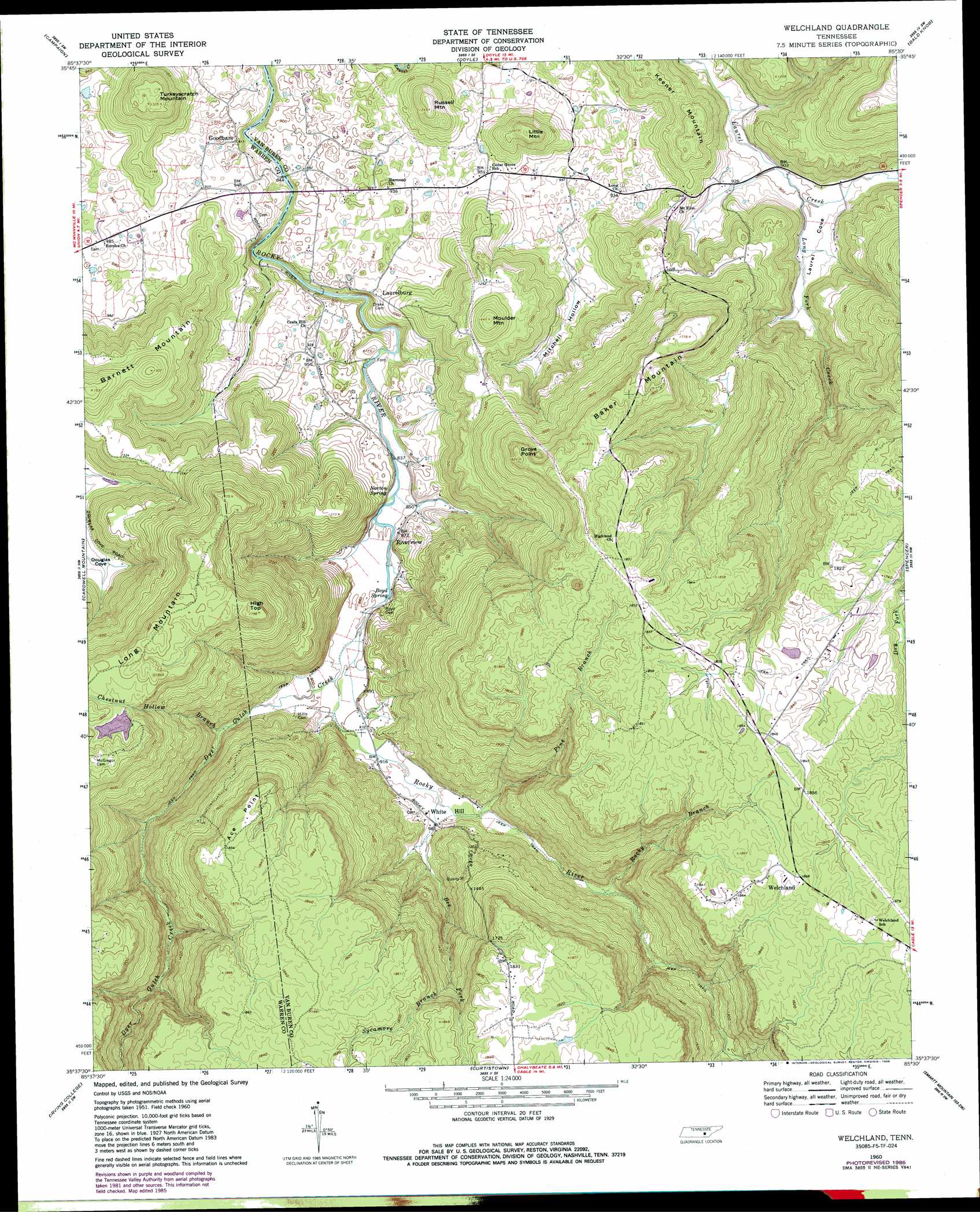
Welchland Topo Map Tennessee
To zoom in, hover over the map of Welchland
USGS Topo Quad 35085f5 - 1:24,000 scale
| Topo Map Name: | Welchland |
| USGS Topo Quad ID: | 35085f5 |
| Print Size: | ca. 21 1/4" wide x 27" high |
| Southeast Coordinates: | 35.625° N latitude / 85.5° W longitude |
| Map Center Coordinates: | 35.6875° N latitude / 85.5625° W longitude |
| U.S. State: | TN |
| Filename: | o35085f5.jpg |
| Download Map JPG Image: | Welchland topo map 1:24,000 scale |
| Map Type: | Topographic |
| Topo Series: | 7.5´ |
| Map Scale: | 1:24,000 |
| Source of Map Images: | United States Geological Survey (USGS) |
| Alternate Map Versions: |
Welchland TN 1960, updated 1961 Download PDF Buy paper map Welchland TN 1960, updated 1986 Download PDF Buy paper map Welchland TN 2010 Download PDF Buy paper map Welchland TN 2013 Download PDF Buy paper map Welchland TN 2016 Download PDF Buy paper map |
1:24,000 Topo Quads surrounding Welchland
Smithville |
Sligo Bridge |
Cassville |
Sparta |
De Rossett |
Dibrell |
Campaign |
Doyle |
Bald Knob |
Lonewood |
Mcminnville |
Cardwell Mountain |
Welchland |
Spencer |
Sampson |
Viola |
Irving College |
Curtistown |
Smartt Mountain |
Brockdell |
Cane Hollow |
Altamont |
Collins |
Savage Point |
Mount Airy |
> Back to 35085e1 at 1:100,000 scale
> Back to 35084a1 at 1:250,000 scale
> Back to U.S. Topo Maps home
Welchland topo map: Gazetteer
Welchland: Bridges
Goodbar Bridge elevation 249m 816′Laurelburg Bridge elevation 245m 803′
Welchland: Capes
Ace Point elevation 556m 1824′Grove Point elevation 555m 1820′
Welchland: Dams
Boyd Brothers Lake Dam elevation 526m 1725′Welchland: Mines
Rocky Branch Mine elevation 522m 1712′Welchland: Populated Places
Caneridge (historical) elevation 286m 938′Cedar Grove elevation 292m 958′
Goodbars elevation 282m 925′
Harmony elevation 283m 928′
Hillis (historical) elevation 300m 984′
Laurel Cove (historical) elevation 281m 921′
Laurelburg elevation 293m 961′
Riverview elevation 262m 859′
Sopha (historical) elevation 561m 1840′
Welchland elevation 569m 1866′
White Hill elevation 293m 961′
Welchland: Reservoirs
Boyd Brothers Lake elevation 526m 1725′Welchland: Springs
Boyd Spring elevation 265m 869′Norton Spring elevation 261m 856′
Welchland: Streams
Bee Fork elevation 286m 938′Chestnut Hollow Branch elevation 288m 944′
Dyer Gulch Creek elevation 267m 875′
Long Fork Creek elevation 273m 895′
Pine Branch elevation 291m 954′
Rocky Branch elevation 308m 1010′
Sycamore Branch elevation 426m 1397′
Welchland: Summits
Baker Mountain elevation 554m 1817′Barnett Mountain elevation 466m 1528′
High Top elevation 547m 1794′
Keener Mountain elevation 379m 1243′
Little Mountain elevation 390m 1279′
Long Mountain elevation 562m 1843′
Moulder Mountain elevation 441m 1446′
Russell Mountain elevation 380m 1246′
Turkeyscratch Mountain elevation 404m 1325′
Welchland: Valleys
Dyer Gulch elevation 269m 882′Laurel Cove elevation 276m 905′
Mitchell Hollow elevation 286m 938′
Narrow Cove elevation 299m 980′
Welchland digital topo map on disk
Buy this Welchland topo map showing relief, roads, GPS coordinates and other geographical features, as a high-resolution digital map file on DVD: