Mcclure Reservoir Topo Map New Mexico
To zoom in, hover over the map of Mcclure Reservoir
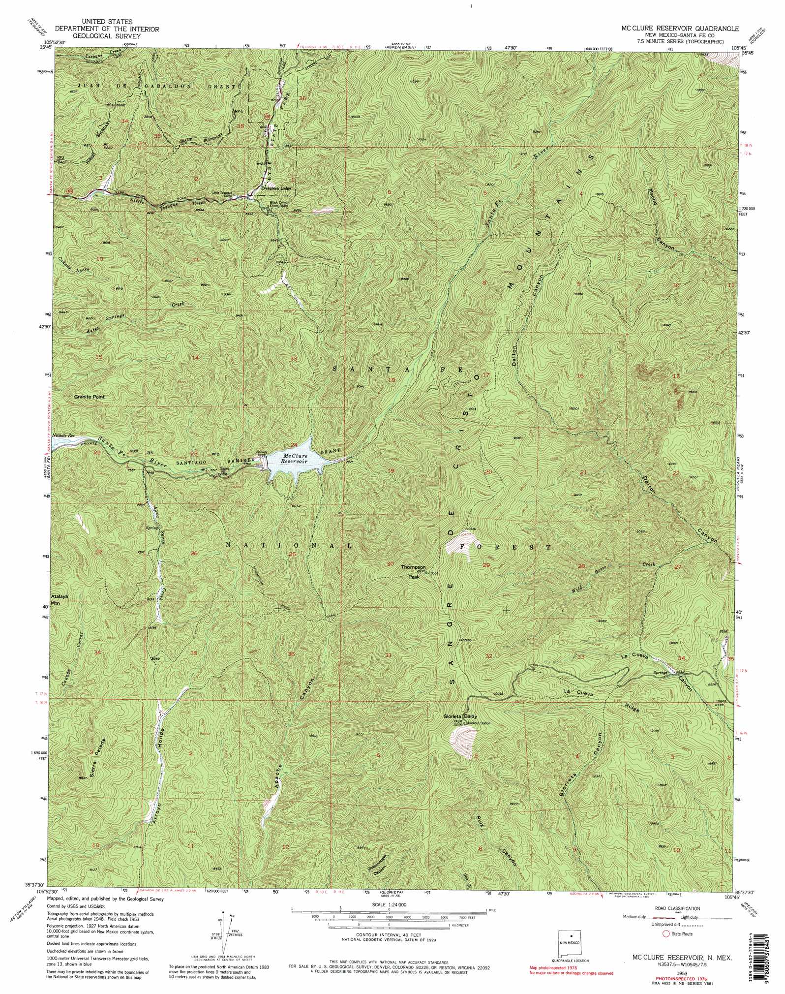
USGS Topo Quad 35105f7 - 1:24,000 scale
| Topo Map Name: | Mcclure Reservoir |
| USGS Topo Quad ID: | 35105f7 |
| Print Size: | ca. 21 1/4" wide x 27" high |
| Southeast Coordinates: | 35.625° N latitude / 105.75° W longitude |
| Map Center Coordinates: | 35.6875° N latitude / 105.8125° W longitude |
| U.S. State: | NM |
| Filename: | o35105f7.jpg |
| Download Map JPG Image: | Mcclure Reservoir topo map 1:24,000 scale |
| Map Type: | Topographic |
| Topo Series: | 7.5´ |
| Map Scale: | 1:24,000 |
| Source of Map Images: | United States Geological Survey (USGS) |
| Alternate Map Versions: |
Mc Clure Reservoir NM 1953, updated 1955 Download PDF Buy paper map Mc Clure Reservoir NM 1953, updated 1963 Download PDF Buy paper map Mc Clure Reservoir NM 1953, updated 1973 Download PDF Buy paper map Mc Clure Reservoir NM 1953, updated 1980 Download PDF Buy paper map Mc Clure Reservoir NM 1953, updated 1980 Download PDF Buy paper map Mc Clure Reservoir NM 2002, updated 2003 Download PDF Buy paper map McClure Reservoir NM 2011 Download PDF Buy paper map McClure Reservoir NM 2013 Download PDF Buy paper map McClure Reservoir NM 2017 Download PDF Buy paper map |
| FStopo: | US Forest Service topo McClure Reservoir is available: Download FStopo PDF Download FStopo TIF |
1:24,000 Topo Quads surrounding Mcclure Reservoir
Espanola |
Cundiyo |
Sierra Mosca |
Truchas Peak |
Pecos Falls |
Horcado Ranch |
Tesuque |
Aspen Basin |
Cowles |
Elk Mountain |
Agua Fria |
Santa Fe |
Mcclure Reservoir |
Rosilla Peak |
Honey Boy Ranch |
Turquoise Hill |
Seton Village |
Glorieta |
Pecos |
Lower Colonias |
Picture Rock |
Galisteo |
Bull Canyon |
Rowe |
North San Ysidro |
> Back to 35105e1 at 1:100,000 scale
> Back to 35104a1 at 1:250,000 scale
> Back to U.S. Topo Maps home
Mcclure Reservoir topo map: Gazetteer
Mcclure Reservoir: Dams
McClure Dam elevation 2587m 8487′Mcclure Reservoir: Parks
Hyde Memorial State Park elevation 2613m 8572′Mcclure Reservoir: Reservoirs
Granite Point Reservoir elevation 2587m 8487′McClure Reservoir elevation 2404m 7887′
Mcclure Reservoir: Ridges
La Cueva Ridge elevation 2770m 9087′Sierra Pelada elevation 2687m 8815′
Mcclure Reservoir: Streams
Agua Sarca Creek elevation 2315m 7595′Wild Horse Creek elevation 2390m 7841′
Mcclure Reservoir: Summits
Glorieta Baldy elevation 3114m 10216′Granite Point elevation 2528m 8293′
Monument Rock elevation 2828m 9278′
Thompson Peak elevation 3214m 10544′
Mcclure Reservoir: Trails
Atalaya Trail elevation 2699m 8854′Chamiza Trail elevation 2598m 8523′
Thompson Peak Trail elevation 2783m 9130′
Mcclure Reservoir digital topo map on disk
Buy this Mcclure Reservoir topo map showing relief, roads, GPS coordinates and other geographical features, as a high-resolution digital map file on DVD: