Albuquerque East Topo Map New Mexico
To zoom in, hover over the map of Albuquerque East
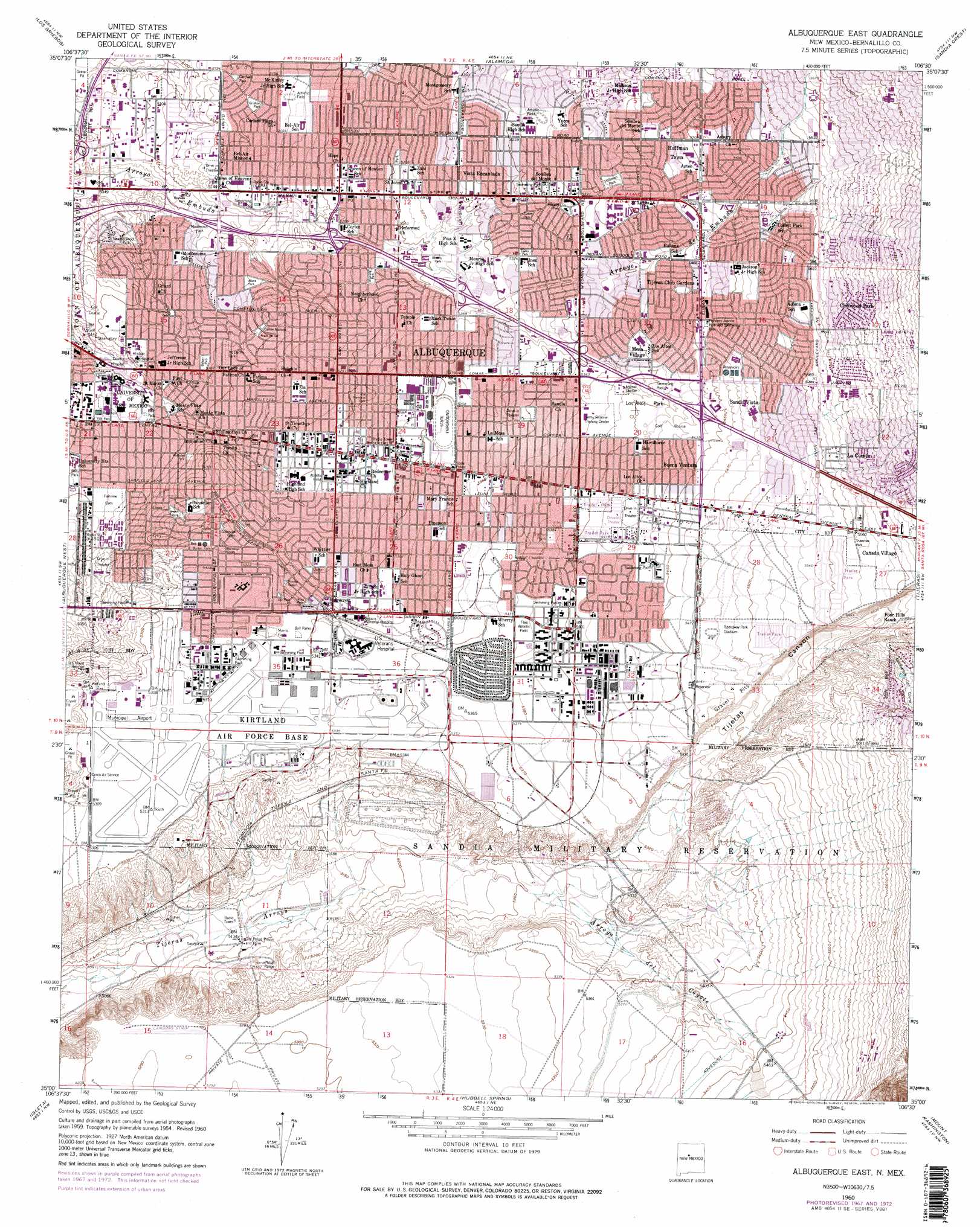
USGS Topo Quad 35106a5 - 1:24,000 scale
| Topo Map Name: | Albuquerque East |
| USGS Topo Quad ID: | 35106a5 |
| Print Size: | ca. 21 1/4" wide x 27" high |
| Southeast Coordinates: | 35° N latitude / 106.5° W longitude |
| Map Center Coordinates: | 35.0625° N latitude / 106.5625° W longitude |
| U.S. State: | NM |
| Filename: | o35106a5.jpg |
| Download Map JPG Image: | Albuquerque East topo map 1:24,000 scale |
| Map Type: | Topographic |
| Topo Series: | 7.5´ |
| Map Scale: | 1:24,000 |
| Source of Map Images: | United States Geological Survey (USGS) |
| Alternate Map Versions: |
East Albuquerque NM 1934 Download PDF Buy paper map Albuquerque East NM 1954, updated 1955 Download PDF Buy paper map Albuquerque East NM 1960, updated 1960 Download PDF Buy paper map Albuquerque East NM 1960, updated 1969 Download PDF Buy paper map Albuquerque East NM 1960, updated 1975 Download PDF Buy paper map Albuquerque East NM 1990, updated 1996 Download PDF Buy paper map Albuquerque East NM 2010 Download PDF Buy paper map Albuquerque East NM 2013 Download PDF Buy paper map Albuquerque East NM 2017 Download PDF Buy paper map |
| FStopo: | US Forest Service topo Albuquerque East is available: Download FStopo PDF Download FStopo TIF |
1:24,000 Topo Quads surrounding Albuquerque East
Sky Village Se |
Loma Machete |
Bernalillo |
Placitas |
Hagan |
Volcano Ranch |
Los Griegos |
Alameda |
Sandia Crest |
Sandia Park |
La Mesita Negra Se |
Albuquerque West |
Albuquerque East |
Tijeras |
Sedillo |
Wind Mesa |
Isleta |
Hubbell Spring |
Mount Washington |
Escabosa |
Dalies |
Los Lunas |
Los Lunas Se |
Bosque Peak |
Tajique |
> Back to 35106a1 at 1:100,000 scale
> Back to 35106a1 at 1:250,000 scale
> Back to U.S. Topo Maps home
Albuquerque East topo map: Gazetteer
Albuquerque East: Airports
Albuquerque International Airport elevation 1620m 5314′Albuquerque East: Arroyos
Arroyo del Coyote elevation 1602m 5255′Albuquerque East: Dams
Juan Tabo Detention Dam elevation 1736m 5695′Albuquerque East: Mines
Ambrell Pit elevation 1663m 5456′Douglas Pit elevation 1663m 5456′
Martin Pit elevation 1663m 5456′
New Pueblo Limestone Quarry elevation 1663m 5456′
Osuna elevation 1591m 5219′
Prager Plant elevation 1617m 5305′
Scott Pit elevation 1663m 5456′
Westland Pit elevation 1663m 5456′
Albuquerque East: Parks
Altura Park elevation 1581m 5187′Alvarado Park elevation 1597m 5239′
Balduini Park elevation 1556m 5104′
Bataan Park elevation 1582m 5190′
Beverly Park elevation 1607m 5272′
Burton Park elevation 1620m 5314′
Campo Manana elevation 1588m 5209′
Cardwell Park elevation 1566m 5137′
Cutler Park elevation 1628m 5341′
Eunice Kaloch Park elevation 1612m 5288′
Flag Athletic Field elevation 1639m 5377′
Fox Memorial Park elevation 1604m 5262′
Grisham Park elevation 1570m 5150′
Hermosa Green elevation 1622m 5321′
Hoffman Park elevation 1652m 5419′
Hyder Park elevation 1603m 5259′
Inez Park elevation 1638m 5374′
Los Altos Park elevation 1652m 5419′
McDuffie Park elevation 1584m 5196′
Monroe Green Park elevation 1621m 5318′
Morningside Park elevation 1597m 5239′
Morris Field elevation 1626m 5334′
Netherwood Park elevation 1553m 5095′
Prado del Sol elevation 1585m 5200′
Princess Jeanne Park and Swimming Pool elevation 1668m 5472′
Prospect Park elevation 1640m 5380′
Ridgecrest Park elevation 1614m 5295′
Roma Green elevation 1583m 5193′
Ross Park elevation 1623m 5324′
Shawshaw Park elevation 1697m 5567′
Speedway Park Stadium elevation 1670m 5479′
Summit Park elevation 1571m 5154′
Taylor Park elevation 1626m 5334′
Urban Forest elevation 1562m 5124′
Vail Park elevation 1625m 5331′
Wellesley Park elevation 1591m 5219′
Yale Park elevation 1576m 5170′
Albuquerque East: Populated Places
Buena Ventura elevation 1656m 5433′Cañada Village elevation 1708m 5603′
Chelwood Park elevation 1738m 5702′
Hoffmantown elevation 1668m 5472′
La Cuesta elevation 1715m 5626′
Mesa Village elevation 1642m 5387′
Sandia Vista elevation 1677m 5501′
Vista Encantada elevation 1620m 5314′
Albuquerque East: Post Offices
La Cuesta Post Office (historical) elevation 1715m 5626′Albuquerque East: Reservoirs
Burton Reservoir elevation 1921m 6302′Miles Reservoir elevation 1901m 6236′
Ridgecrest Reservoir elevation 1901m 6236′
Albuquerque East: Valleys
Tijeras Canyon elevation 1614m 5295′Albuquerque East: Wells
10056 Water Well elevation 1620m 5314′Bel Air 1 Water Well elevation 1588m 5209′
Belair 3 Water Well elevation 1575m 5167′
Burton 1 Water Well elevation 1621m 5318′
Burton 2 Water Well elevation 1611m 5285′
Burton 3 Water Well elevation 1590m 5216′
Burton 4 Water Well elevation 1607m 5272′
Charles 1 Water Well elevation 1621m 5318′
Charles 2 Water Well elevation 1606m 5269′
Charles 3 Water Well elevation 1608m 5275′
Charles 4 Water Well elevation 1623m 5324′
Kirtland Air Force Base 1 Water Well elevation 1623m 5324′
Kirtland Air Force Base 2 Water Well elevation 1620m 5314′
Leyendecker 2 Water Well elevation 1615m 5298′
Lomas 1 Water Well elevation 1708m 5603′
Lomas 2 Water Well elevation 1701m 5580′
Lomas 3 Water Well elevation 1717m 5633′
Lomas 4 Water Well elevation 1699m 5574′
Lomas 5 Water Well elevation 1677m 5501′
Lomas 6 Water Well elevation 1686m 5531′
Lomas 7 Water Well elevation 1676m 5498′
Lomas 8 Water Well elevation 1686m 5531′
Love 2 Water Well elevation 1659m 5442′
Love 3 Water Well elevation 1650m 5413′
Love 5 Water Well elevation 1644m 5393′
Love 6 Water Well elevation 1678m 5505′
Love 7 Water Well elevation 1658m 5439′
Lovefield 4 Water Well elevation 1638m 5374′
Lovefield I Water Well elevation 1665m 5462′
Number 4 Water Well elevation 1623m 5324′
Number 9 Water Well elevation 1677m 5501′
RG-9302-S Water Well elevation 1642m 5387′
RG9302-S-2 Water Well elevation 1629m 5344′
Ridgecrest 1 Water Well elevation 1659m 5442′
Ridgecrest 2 Water Well elevation 1652m 5419′
Sandia 1 Water Well elevation 1642m 5387′
Sandia 2 Water Well elevation 1626m 5334′
Sandia 4 Water Well elevation 1634m 5360′
Sandia 5 Water Well elevation 1657m 5436′
Sandia 6 Water Well elevation 1653m 5423′
Sandia 7 Water Well elevation 1631m 5351′
Sandia 8 Water Well elevation 1638m 5374′
Sandia Water Well elevation 1633m 5357′
Santa Barbara 1 Water Well elevation 1568m 5144′
United States Air Force 14 Water Well elevation 1602m 5255′
UNIV 3 Water Well elevation 1563m 5127′
Yale 1 Water Well elevation 1572m 5157′
Albuquerque East digital topo map on disk
Buy this Albuquerque East topo map showing relief, roads, GPS coordinates and other geographical features, as a high-resolution digital map file on DVD: