Strawberry Crater Topo Map Arizona
To zoom in, hover over the map of Strawberry Crater
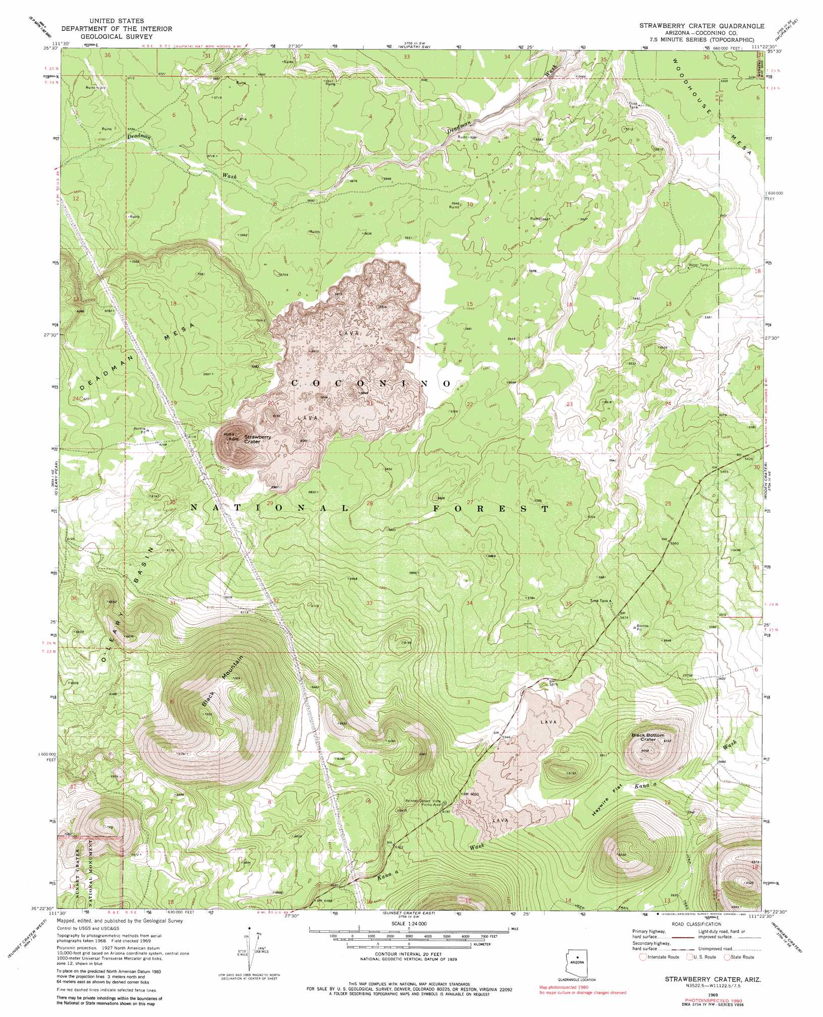
USGS Topo Quad 35111d4 - 1:24,000 scale
| Topo Map Name: | Strawberry Crater |
| USGS Topo Quad ID: | 35111d4 |
| Print Size: | ca. 21 1/4" wide x 27" high |
| Southeast Coordinates: | 35.375° N latitude / 111.375° W longitude |
| Map Center Coordinates: | 35.4375° N latitude / 111.4375° W longitude |
| U.S. State: | AZ |
| Filename: | o35111d4.jpg |
| Download Map JPG Image: | Strawberry Crater topo map 1:24,000 scale |
| Map Type: | Topographic |
| Topo Series: | 7.5´ |
| Map Scale: | 1:24,000 |
| Source of Map Images: | United States Geological Survey (USGS) |
| Alternate Map Versions: |
Strawberry Crater AZ 1969, updated 1972 Download PDF Buy paper map Strawberry Crater AZ 1969, updated 1983 Download PDF Buy paper map Strawberry Crater AZ 1969, updated 1983 Download PDF Buy paper map Strawberry Crater AZ 2011 Download PDF Buy paper map Strawberry Crater AZ 2014 Download PDF Buy paper map |
| FStopo: | US Forest Service topo Strawberry Crater is available: Download FStopo PDF Download FStopo TIF |
1:24,000 Topo Quads surrounding Strawberry Crater
Additional Hill |
Campbell Francis Wash |
Gray Mountain |
Wupatki Ne |
Badger Spring |
S P Mountain |
East Of S P Mountain |
Wupatki Sw |
Wupatki Se |
Standing Rocks |
White Horse Hills |
O'Leary Peak |
Strawberry Crater |
Roden Crater |
Grand Falls |
Humphreys Peak |
Sunset Crater West |
Sunset Crater East |
Merriam Crater |
Grand Falls Sw |
Flagstaff West |
Flagstaff East |
Winona |
Angell |
Babbitt Wash |
> Back to 35111a1 at 1:100,000 scale
> Back to 35110a1 at 1:250,000 scale
> Back to U.S. Topo Maps home
Strawberry Crater topo map: Gazetteer
Strawberry Crater: Basins
Oleary Basin elevation 1896m 6220′Strawberry Crater: Craters
Black Bottom Crater elevation 1853m 6079′Strawberry Crater elevation 1921m 6302′
Strawberry Crater: Flats
Haywire Flat elevation 1789m 5869′Strawberry Crater: Lavas
Kana-a Lava Flow elevation 1821m 5974′Strawberry Crater: Parks
Painted Desert Vista Picnic Area elevation 1888m 6194′Strawberry Crater: Reservoirs
Section 13 Water Tank elevation 1640m 5380′Trick Tank elevation 1627m 5337′
Trick Tank elevation 1732m 5682′
Strawberry Crater: Summits
Black Mountain elevation 2302m 7552′Strawberry Crater digital topo map on disk
Buy this Strawberry Crater topo map showing relief, roads, GPS coordinates and other geographical features, as a high-resolution digital map file on DVD: