S P Mountain Topo Map Arizona
To zoom in, hover over the map of S P Mountain
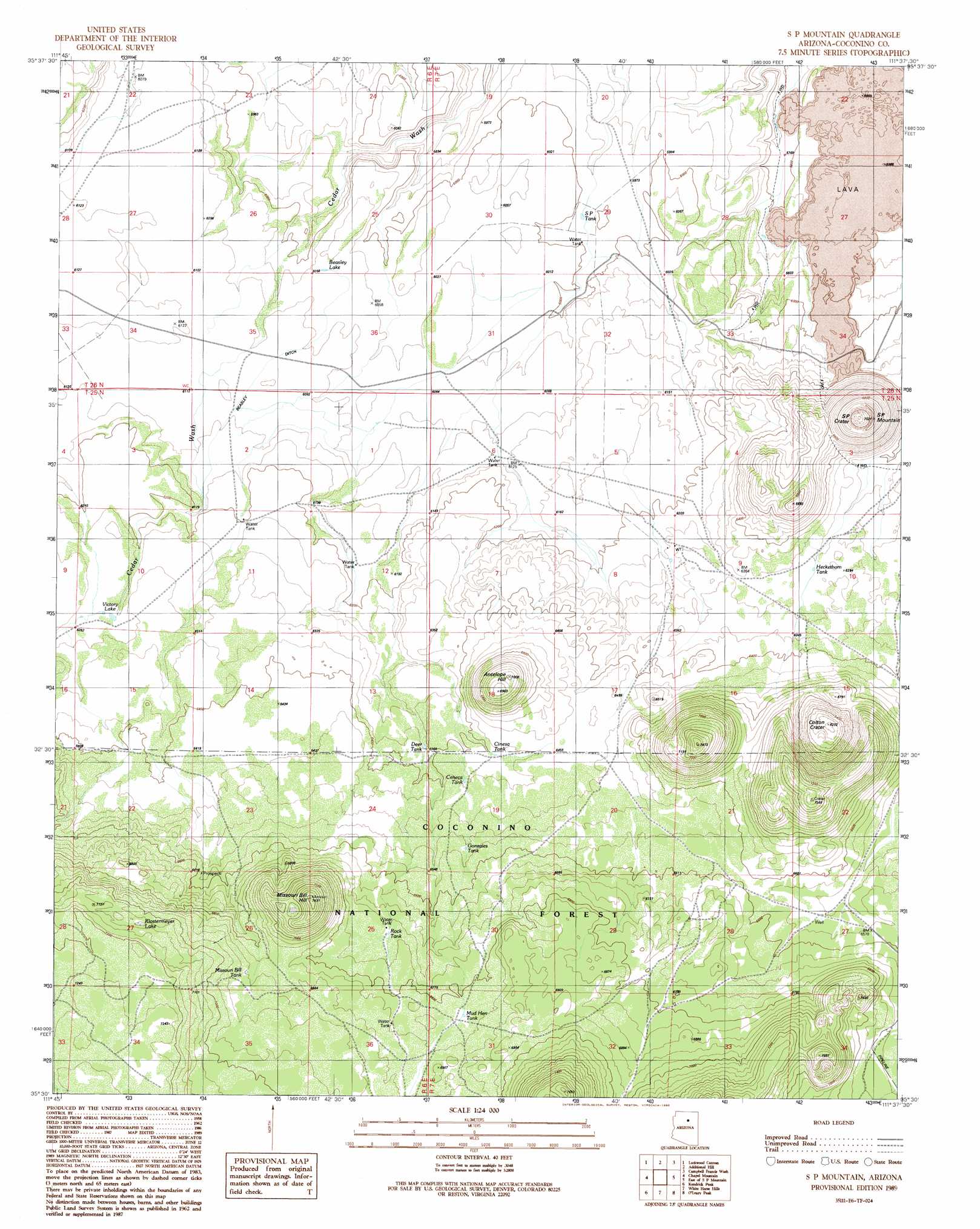
USGS Topo Quad 35111e6 - 1:24,000 scale
| Topo Map Name: | S P Mountain |
| USGS Topo Quad ID: | 35111e6 |
| Print Size: | ca. 21 1/4" wide x 27" high |
| Southeast Coordinates: | 35.5° N latitude / 111.625° W longitude |
| Map Center Coordinates: | 35.5625° N latitude / 111.6875° W longitude |
| U.S. State: | AZ |
| Filename: | o35111e6.jpg |
| Download Map JPG Image: | S P Mountain topo map 1:24,000 scale |
| Map Type: | Topographic |
| Topo Series: | 7.5´ |
| Map Scale: | 1:24,000 |
| Source of Map Images: | United States Geological Survey (USGS) |
| Alternate Map Versions: |
S P Mountain AZ 1989, updated 1990 Download PDF Buy paper map S P Mountain AZ 2011 Download PDF Buy paper map S P Mountain AZ 2014 Download PDF Buy paper map |
| FStopo: | US Forest Service topo S P Mountain is available: Download FStopo PDF Download FStopo TIF |
1:24,000 Topo Quads surrounding S P Mountain
Harbison Tank |
Peterson Flat |
Willows Camp |
Coconino Point Se |
Cameron South |
Dog Knobs |
Lockwood Canyon |
Additional Hill |
Campbell Francis Wash |
Gray Mountain |
Ebert Mountain |
Chapel Mountain |
S P Mountain |
East Of S P Mountain |
Wupatki Sw |
Moritz Ridge |
Kendrick Peak |
White Horse Hills |
O'Leary Peak |
Strawberry Crater |
Parks |
Wing Mountain |
Humphreys Peak |
Sunset Crater West |
Sunset Crater East |
> Back to 35111e1 at 1:100,000 scale
> Back to 35110a1 at 1:250,000 scale
> Back to U.S. Topo Maps home
S P Mountain topo map: Gazetteer
S P Mountain: Canals
Beasley Ditch elevation 1860m 6102′S P Mountain: Craters
Colton Crater elevation 1904m 6246′S P Crater elevation 2035m 6676′
S P Mountain: Lakes
Beasley Lake elevation 1848m 6062′Klostermeyer Lake elevation 2147m 7043′
Victory Lake elevation 1907m 6256′
S P Mountain: Reservoirs
Aso Tank elevation 1905m 6250′Ceneca Tank elevation 1963m 6440′
Cinesa Tank elevation 1954m 6410′
Deer Tank elevation 1939m 6361′
Gonzales Tank elevation 1995m 6545′
Heckethorn Tank elevation 1918m 6292′
Missouri Bill Tank elevation 2099m 6886′
Mud Hen Tank elevation 2081m 6827′
Rock Tank elevation 2055m 6742′
S P Tank elevation 1827m 5994′
S P Mountain: Summits
Antelope Hill elevation 2124m 6968′Missouri Bill Hill elevation 2260m 7414′
S P Mountain elevation 2108m 6916′
S P Mountain digital topo map on disk
Buy this S P Mountain topo map showing relief, roads, GPS coordinates and other geographical features, as a high-resolution digital map file on DVD: