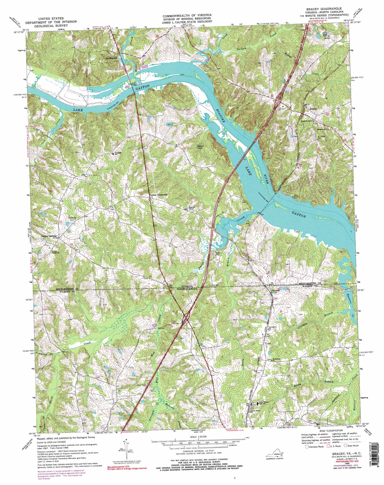
Bracey Topo Map Virginia
To zoom in, hover over the map of Bracey
USGS Topo Quad 36078e2 - 1:24,000 scale
| Topo Map Name: | Bracey |
| USGS Topo Quad ID: | 36078e2 |
| Print Size: | ca. 21 1/4" wide x 27" high |
| Southeast Coordinates: | 36.5° N latitude / 78.125° W longitude |
| Map Center Coordinates: | 36.5625° N latitude / 78.1875° W longitude |
| U.S. States: | VA, NC |
| Filename: | o36078e2.jpg |
| Download Map JPG Image: | Bracey topo map 1:24,000 scale |
| Map Type: | Topographic |
| Topo Series: | 7.5´ |
| Map Scale: | 1:24,000 |
| Source of Map Images: | United States Geological Survey (USGS) |
| Alternate Map Versions: |
Bracey VA 1968, updated 1972 Download PDF Buy paper map Bracey VA 1968, updated 1975 Download PDF Buy paper map Bracey VA 1968, updated 1975 Download PDF Buy paper map Bracey VA 1968, updated 1979 Download PDF Buy paper map Bracey VA 1977, updated 1979 Download PDF Buy paper map Bracey VA 2010 Download PDF Buy paper map Bracey VA 2013 Download PDF Buy paper map Bracey VA 2016 Download PDF Buy paper map |
1:24,000 Topo Quads surrounding Bracey
Chase City |
Wightman |
North View |
Forksville |
Alberta |
Boydton |
Baskerville |
South Hill |
La Crosse |
White Plains |
Tungsten |
John H Kerr Dam |
Bracey |
South Hill Se |
Gasburg |
Townsville |
Middleburg |
Warrenton |
Macon |
Littleton |
Henderson |
Vicksboro |
Afton |
Inez |
Hollister |
> Back to 36078e1 at 1:100,000 scale
> Back to 36078a1 at 1:250,000 scale
> Back to U.S. Topo Maps home
Bracey topo map: Gazetteer
Bracey: Bridges
Goodes Ferry Bridge elevation 61m 200′Bracey: Crossings
Interchange 4 elevation 108m 354′Saint Tammany Ferry (historical) elevation 61m 200′
Bracey: Dams
River Ridge Dam elevation 78m 255′Bracey: Lakes
Beaver Pond elevation 69m 226′Bracey: Populated Places
Beechwood elevation 65m 213′Bracey elevation 104m 341′
Bracy Station elevation 103m 337′
Palmer Crossroads elevation 95m 311′
Palmer Springs elevation 117m 383′
Paschall elevation 94m 308′
Tazewell (historical) elevation 68m 223′
Whitby (historical) elevation 79m 259′
Bracey: Reservoirs
River Ridge Pond elevation 78m 255′Bracey: Streams
Blue Mud Creek elevation 63m 206′Cabin Branch elevation 72m 236′
Coleman Branch elevation 61m 200′
Cotton Creek elevation 61m 200′
Flat Creek elevation 61m 200′
Hawtree Creek elevation 61m 200′
Hawtree Creek elevation 61m 200′
Hewey Creek elevation 66m 216′
Malones Creek elevation 67m 219′
Miles Creek elevation 61m 200′
Newmans Creek elevation 68m 223′
Parham Creek elevation 63m 206′
Reedy Branch elevation 61m 200′
Reedy Branch elevation 61m 200′
Rocky Branch elevation 63m 206′
Smith Creek elevation 61m 200′
Smith Creek elevation 61m 200′
Terrapin Creek elevation 67m 219′
Bracey digital topo map on disk
Buy this Bracey topo map showing relief, roads, GPS coordinates and other geographical features, as a high-resolution digital map file on DVD:
Western Virginia & Southern West Virginia
Buy digital topo maps: Western Virginia & Southern West Virginia