Caruthersville Se Topo Map Tennessee
To zoom in, hover over the map of Caruthersville Se
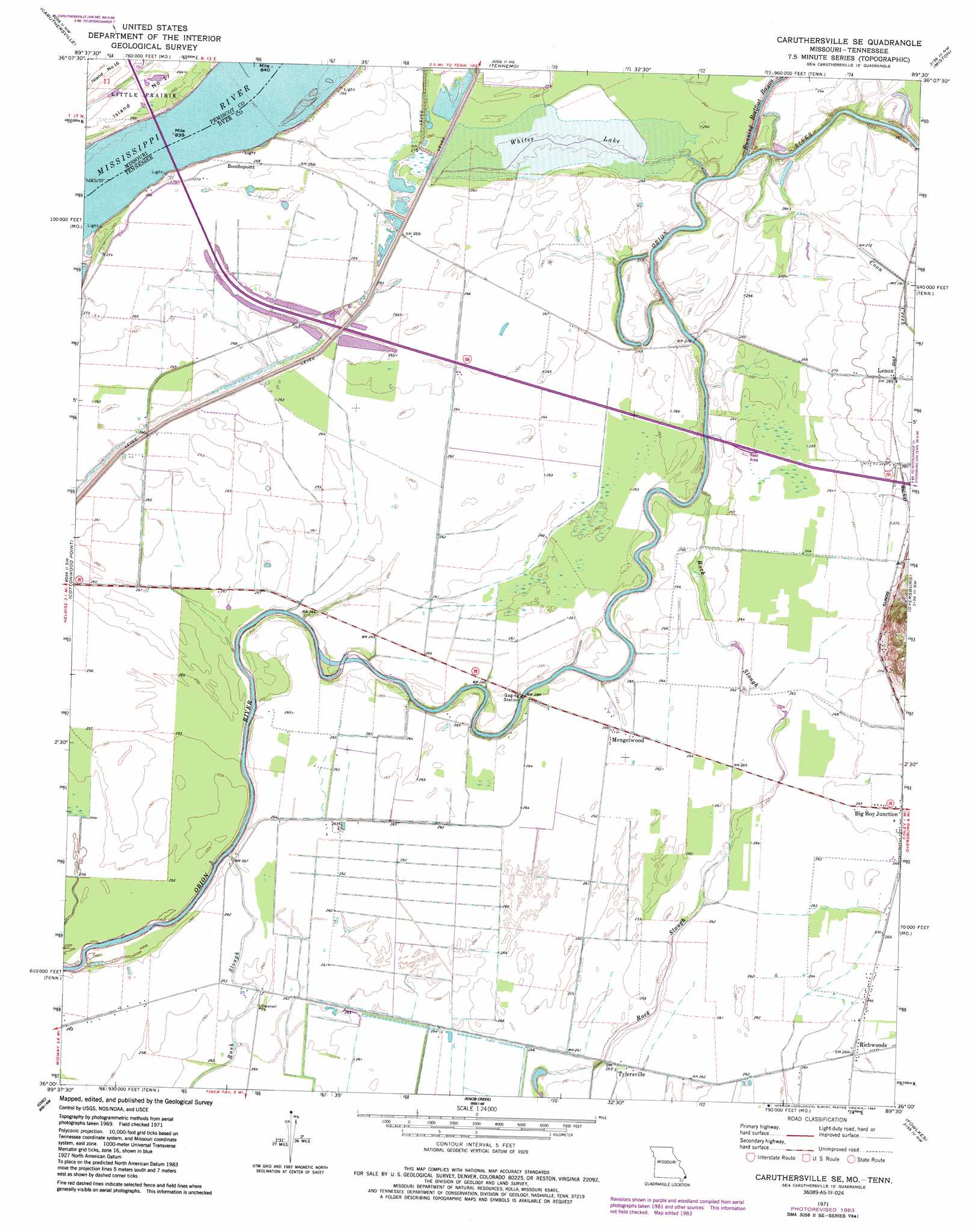
USGS Topo Quad 36089a5 - 1:24,000 scale
| Topo Map Name: | Caruthersville Se |
| USGS Topo Quad ID: | 36089a5 |
| Print Size: | ca. 21 1/4" wide x 27" high |
| Southeast Coordinates: | 36° N latitude / 89.5° W longitude |
| Map Center Coordinates: | 36.0625° N latitude / 89.5625° W longitude |
| U.S. States: | TN, MO |
| Filename: | o36089a5.jpg |
| Download Map JPG Image: | Caruthersville Se topo map 1:24,000 scale |
| Map Type: | Topographic |
| Topo Series: | 7.5´ |
| Map Scale: | 1:24,000 |
| Source of Map Images: | United States Geological Survey (USGS) |
| Alternate Map Versions: |
Caruthersville SE TN 1971, updated 1972 Download PDF Buy paper map Caruthersville SE TN 1971, updated 1984 Download PDF Buy paper map Caruthersville SE TN 2010 Download PDF Buy paper map Caruthersville SE TN 2013 Download PDF Buy paper map Caruthersville SE TN 2016 Download PDF Buy paper map |
1:24,000 Topo Quads surrounding Caruthersville Se
Wardell |
Stanley |
Mooring |
Ridgely |
Hornbeak |
Hayti Heights |
Caruthersville |
Tennemo |
Miston |
Lane |
Steele |
Cottonwood Point |
Caruthersville Se |
Dyersburg |
Newbern |
Armorel |
Chic |
Knob Creek |
Fowlkes |
Bonicord |
Rosa |
Open Lake |
Ripley North |
Gates |
Chestnut Bluff |
> Back to 36089a1 at 1:100,000 scale
> Back to 36088a1 at 1:250,000 scale
> Back to U.S. Topo Maps home
Caruthersville Se topo map: Gazetteer
Caruthersville Se: Areas
Island Number 17 elevation 79m 259′Caruthersville Se: Bends
Linwood Bend elevation 73m 239′Caruthersville Se: Capes
Booth Point elevation 79m 259′Caruthersville Se: Flats
Whites Lake elevation 82m 269′Caruthersville Se: Guts
Rush Slough elevation 76m 249′Caruthersville Se: Levees
Booth Point Dikes elevation 79m 259′Linwood Bend Revetment elevation 77m 252′
Caruthersville Se: Populated Places
Boothspoint elevation 80m 262′Mengelwood elevation 81m 265′
Richwoods elevation 81m 265′
Tylersville elevation 79m 259′
Caruthersville Se: Streams
Coon Creek elevation 78m 255′Rock Slough elevation 75m 246′
Running Reelfoot Bayou elevation 76m 249′
Caruthersville Se digital topo map on disk
Buy this Caruthersville Se topo map showing relief, roads, GPS coordinates and other geographical features, as a high-resolution digital map file on DVD: