Sulphur Spring Topo Map New Mexico
To zoom in, hover over the map of Sulphur Spring
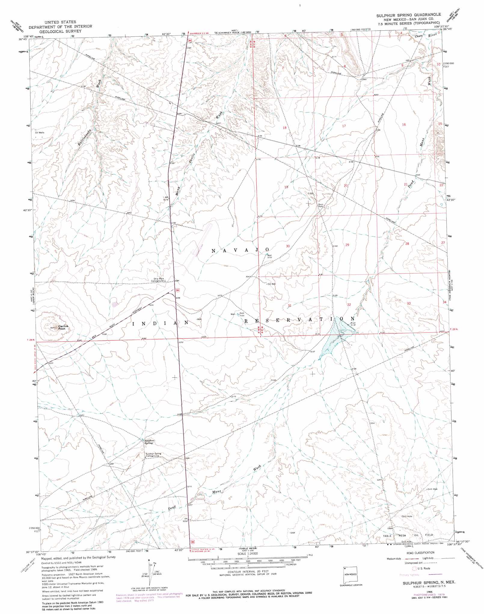
USGS Topo Quad 36108f6 - 1:24,000 scale
| Topo Map Name: | Sulphur Spring |
| USGS Topo Quad ID: | 36108f6 |
| Print Size: | ca. 21 1/4" wide x 27" high |
| Southeast Coordinates: | 36.625° N latitude / 108.625° W longitude |
| Map Center Coordinates: | 36.6875° N latitude / 108.6875° W longitude |
| U.S. State: | NM |
| Filename: | o36108f6.jpg |
| Download Map JPG Image: | Sulphur Spring topo map 1:24,000 scale |
| Map Type: | Topographic |
| Topo Series: | 7.5´ |
| Map Scale: | 1:24,000 |
| Source of Map Images: | United States Geological Survey (USGS) |
| Alternate Map Versions: |
Sulphur Spring NM 1966, updated 1968 Download PDF Buy paper map Sulphur Spring NM 1966, updated 1978 Download PDF Buy paper map Sulphur Spring NM 1966, updated 1980 Download PDF Buy paper map Sulphur Spring NM 2010 Download PDF Buy paper map Sulphur Spring NM 2013 Download PDF Buy paper map Sulphur Spring NM 2017 Download PDF Buy paper map |
1:24,000 Topo Quads surrounding Sulphur Spring
Sallies Spring |
Canal Creek |
Skinney Rock |
Palmer Mesa |
Heifer Point |
Rocky Point |
Rattlesnake |
Shiprock |
Chimney Rock |
Waterflow |
Sand Spring |
Ship Rock |
Sulphur Spring |
The Hogack North |
Fruitland |
Mitten Rock |
Yellow Hill |
Table Mesa |
The Hogback South |
Kirtland Sw |
Sanostee West |
Sanostee East |
Little Water |
Newcomb Ne |
The Pillar Nw |
> Back to 36108e1 at 1:100,000 scale
> Back to 36108a1 at 1:250,000 scale
> Back to U.S. Topo Maps home
Sulphur Spring topo map: Gazetteer
Sulphur Spring: Airports
Shiprock Airstrip elevation 1598m 5242′Sulphur Spring: Dams
Brewster Dam elevation 1562m 5124′Sulphur Spring: Mines
Sulphur Spring elevation 1597m 5239′Sulphur Spring: Springs
112R-78 Spring elevation 1605m 5265′Stinking Springs elevation 1598m 5242′
Sulphur Spring elevation 1596m 5236′
Sulphur Spring: Streams
Dead Mans Wash elevation 1509m 4950′Sulphur Spring: Summits
Cactus Peak elevation 1686m 5531′Sulphur Spring: Wells
12K-309 Water Well elevation 1617m 5305′12T-551 Water Well elevation 1599m 5246′
12T-628 Water Well elevation 1615m 5298′
12T-629 Water Well elevation 1563m 5127′
12T-630 Water Well elevation 1543m 5062′
SJ-525 Water Well elevation 1599m 5246′
Sul Spring 03 Water Well elevation 1586m 5203′
Sulphur Spring digital topo map on disk
Buy this Sulphur Spring topo map showing relief, roads, GPS coordinates and other geographical features, as a high-resolution digital map file on DVD: