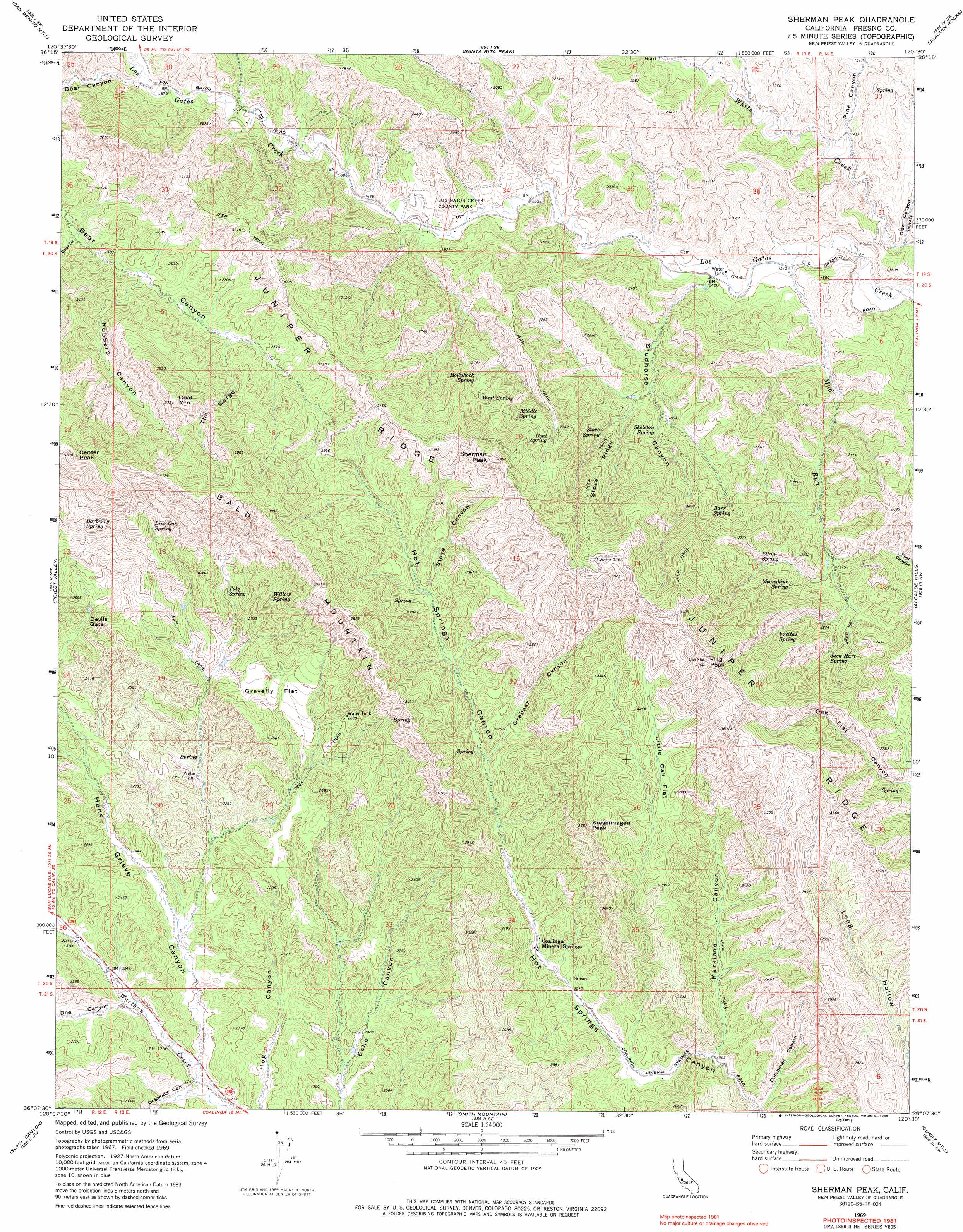
Sherman Peak Topo Map California
To zoom in, hover over the map of Sherman Peak
USGS Topo Quad 36120b5 - 1:24,000 scale
| Topo Map Name: | Sherman Peak |
| USGS Topo Quad ID: | 36120b5 |
| Print Size: | ca. 21 1/4" wide x 27" high |
| Southeast Coordinates: | 36.125° N latitude / 120.5° W longitude |
| Map Center Coordinates: | 36.1875° N latitude / 120.5625° W longitude |
| U.S. State: | CA |
| Filename: | o36120b5.jpg |
| Download Map JPG Image: | Sherman Peak topo map 1:24,000 scale |
| Map Type: | Topographic |
| Topo Series: | 7.5´ |
| Map Scale: | 1:24,000 |
| Source of Map Images: | United States Geological Survey (USGS) |
| Alternate Map Versions: |
Sherman Peak CA 1969, updated 1973 Download PDF Buy paper map Sherman Peak CA 1969, updated 1986 Download PDF Buy paper map Sherman Peak CA 1969, updated 1986 Download PDF Buy paper map Sherman Peak CA 2012 Download PDF Buy paper map Sherman Peak CA 2015 Download PDF Buy paper map |
1:24,000 Topo Quads surrounding Sherman Peak
Hernandez Reservoir |
Idria |
Ciervo Mountain |
Lillis Ranch |
Tres Picos Farms |
Hepsedam Peak |
San Benito Mountain |
Santa Rita Peak |
Joaquin Rocks |
Domengine Ranch |
Monarch Peak |
Priest Valley |
Sherman Peak |
Alcalde Hills |
Coalinga |
Pancho Rico Valley |
Slack Canyon |
Smith Mountain |
Curry Mountain |
Kreyenhagen Hills |
Wunpost |
Valleton |
Stockdale Mountain |
Parkfield |
The Dark Hole |
> Back to 36120a1 at 1:100,000 scale
> Back to 36120a1 at 1:250,000 scale
> Back to U.S. Topo Maps home
Sherman Peak topo map: Gazetteer
Sherman Peak: Flats
Gravelly Flat elevation 759m 2490′Little Oak Flat elevation 871m 2857′
Sherman Peak: Gaps
Devils Gate elevation 708m 2322′Sherman Peak: Parks
Los Gatos Creek County Park elevation 511m 1676′Sherman Peak: Ridges
Bald Mountain elevation 1158m 3799′Juniper Ridge elevation 1161m 3809′
Stove Ridge elevation 811m 2660′
Sherman Peak: Springs
Barberry Spring elevation 1010m 3313′Barr Spring elevation 710m 2329′
Coalinga Mineral Spring elevation 673m 2208′
Coalinga Mineral Springs elevation 634m 2080′
Elliot Spring elevation 695m 2280′
Freitas Spring elevation 767m 2516′
Goat Spring elevation 842m 2762′
Hollyhock Spring elevation 770m 2526′
Jack Hart Spring elevation 696m 2283′
Live Oak Spring elevation 965m 3166′
Middle Spring elevation 844m 2769′
Moonshine Spring elevation 671m 2201′
Rock House Spring elevation 395m 1295′
Skeleton Spring elevation 580m 1902′
Skelton Spring elevation 576m 1889′
Stove Spring elevation 648m 2125′
Tule Spring elevation 801m 2627′
West Spring elevation 828m 2716′
Willow Spring elevation 895m 2936′
Sherman Peak: Streams
Mud Run elevation 405m 1328′Sherman Peak: Summits
Center Peak elevation 1376m 4514′Flag Peak elevation 1210m 3969′
Goat Mountain elevation 1104m 3622′
Kreyenhagen Peak elevation 1063m 3487′
Sherman Peak elevation 1148m 3766′
Sherman Peak: Valleys
Bear Gulch elevation 676m 2217′Bee Canyon elevation 548m 1797′
Chimney Canyon elevation 428m 1404′
Diaz Canyon elevation 396m 1299′
Dogwood Canyon elevation 519m 1702′
Dutchman Canyon elevation 522m 1712′
Grabast Canyon elevation 720m 2362′
Hans Grieve Canyon elevation 528m 1732′
Lewis Canyon elevation 462m 1515′
Markland Canyon elevation 552m 1811′
Pine Canyon elevation 429m 1407′
Robbers Canyon elevation 717m 2352′
Roberts Canyon elevation 729m 2391′
Stove Canyon elevation 796m 2611′
Studhorse Canyon elevation 424m 1391′
The Gorge elevation 766m 2513′
Sherman Peak digital topo map on disk
Buy this Sherman Peak topo map showing relief, roads, GPS coordinates and other geographical features, as a high-resolution digital map file on DVD: