Palmer Topo Map Missouri
To zoom in, hover over the map of Palmer
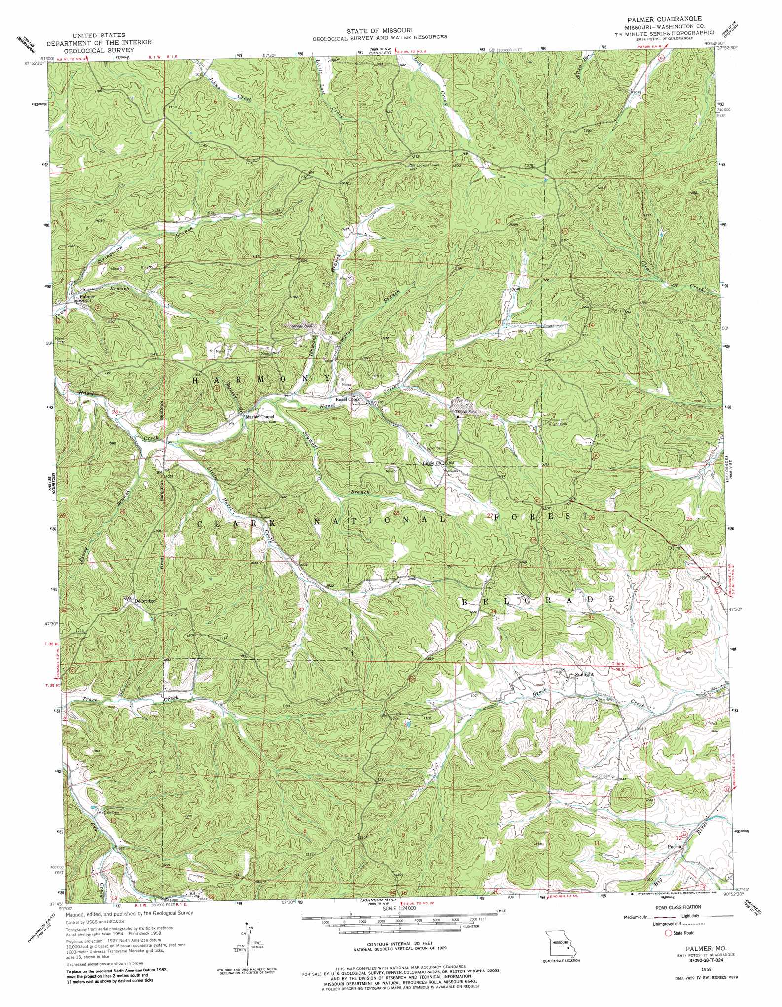
USGS Topo Quad 37090g8 - 1:24,000 scale
| Topo Map Name: | Palmer |
| USGS Topo Quad ID: | 37090g8 |
| Print Size: | ca. 21 1/4" wide x 27" high |
| Southeast Coordinates: | 37.75° N latitude / 90.875° W longitude |
| Map Center Coordinates: | 37.8125° N latitude / 90.9375° W longitude |
| U.S. State: | MO |
| Filename: | o37090g8.jpg |
| Download Map JPG Image: | Palmer topo map 1:24,000 scale |
| Map Type: | Topographic |
| Topo Series: | 7.5´ |
| Map Scale: | 1:24,000 |
| Source of Map Images: | United States Geological Survey (USGS) |
| Alternate Map Versions: |
Palmer MO 1958, updated 1959 Download PDF Buy paper map Palmer MO 1958, updated 1977 Download PDF Buy paper map Palmer MO 1958, updated 1986 Download PDF Buy paper map Palmer MO 1958, updated 1986 Download PDF Buy paper map Palmer MO 1999, updated 2002 Download PDF Buy paper map Palmer MO 2011 Download PDF Buy paper map Palmer MO 2015 Download PDF Buy paper map |
| FStopo: | US Forest Service topo Palmer is available: Download FStopo PDF Download FStopo TIF |
1:24,000 Topo Quads surrounding Palmer
Onondaga Cave |
Anthonies Mill |
Ebo |
Old Mines |
Tiff |
Huzzah |
Berryman |
Shirley |
Potosi |
Mineral Point |
Davisville |
Courtois |
Palmer |
Belgrade |
Irondale |
Viburnum West |
Viburnum East |
Johnson Mountain |
Banner |
Graniteville |
Greeley |
Oates |
Edgehill |
Johnson Shut-Ins |
Ironton |
> Back to 37090e1 at 1:100,000 scale
> Back to 37090a1 at 1:250,000 scale
> Back to U.S. Topo Maps home
Palmer topo map: Gazetteer
Palmer: Dams
Gudaitis Lake Dam elevation 325m 1066′Howell Mine Dam elevation 307m 1007′
Palmer Mine Dam elevation 313m 1026′
Parole Mine Dam elevation 296m 971′
Schnelle Lake Dam elevation 305m 1000′
Palmer: Mines
Bit Lead Diggings elevation 279m 915′Blackwell Lead Diggings elevation 326m 1069′
Booth Lead Diggings elevation 336m 1102′
Clemins Lead Diggings elevation 348m 1141′
Cochran Lead Diggings elevation 317m 1040′
Daylight Lead Diggings elevation 332m 1089′
English Lead Diggings elevation 315m 1033′
Flint Hill Lead Diggings elevation 330m 1082′
Gopher Lead Diggings elevation 326m 1069′
Grave-Yard Lead Diggings elevation 373m 1223′
Hypocrite Lead Diggings elevation 324m 1062′
Ismael Lead Diggings elevation 323m 1059′
Madden Hill Lead Diggings elevation 304m 997′
Montgomery Lead Diggings elevation 323m 1059′
Parole Lead Diggings elevation 350m 1148′
Peru Lead Diggings elevation 344m 1128′
Pigeon-Roost Lead Mine elevation 326m 1069′
Strawberry Lead Diggings elevation 345m 1131′
Sweassey Lead Diggings elevation 345m 1131′
Tarkey Lead Diggings elevation 349m 1145′
Trash Lead Diggings elevation 348m 1141′
Turkey Hill Lead Diggings elevation 354m 1161′
Palmer: Populated Places
Delbridge elevation 374m 1227′Horton Town elevation 317m 1040′
Palmer elevation 274m 898′
Peoria elevation 284m 931′
Sunlight elevation 302m 990′
Palmer: Reservoirs
Gudaitis Lake elevation 325m 1066′Howell Lake elevation 311m 1020′
Palmer Lake elevation 313m 1026′
Parole Lake elevation 296m 971′
Palmer: Streams
Compton Branch elevation 290m 951′Ishmael Branch elevation 286m 938′
Little Hazel Creek elevation 275m 902′
Piney Branch elevation 271m 889′
Seymour Branch Hazel Creek elevation 294m 964′
Stringtown Branch elevation 268m 879′
Sweezy Branch elevation 280m 918′
Palmer: Trails
Trace Creek Trail elevation 316m 1036′Palmer digital topo map on disk
Buy this Palmer topo map showing relief, roads, GPS coordinates and other geographical features, as a high-resolution digital map file on DVD: