Huzzah Topo Map Missouri
To zoom in, hover over the map of Huzzah
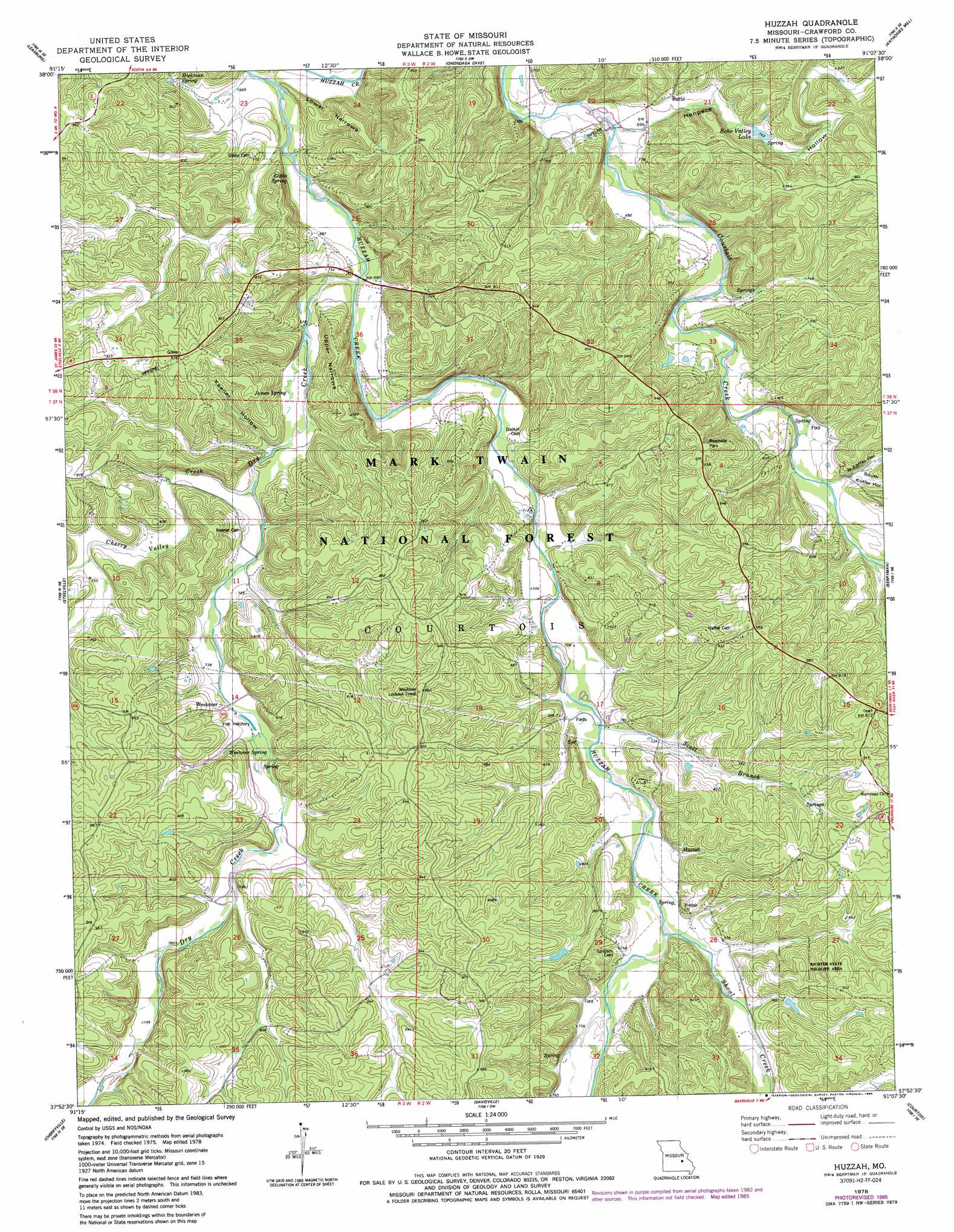
USGS Topo Quad 37091h2 - 1:24,000 scale
| Topo Map Name: | Huzzah |
| USGS Topo Quad ID: | 37091h2 |
| Print Size: | ca. 21 1/4" wide x 27" high |
| Southeast Coordinates: | 37.875° N latitude / 91.125° W longitude |
| Map Center Coordinates: | 37.9375° N latitude / 91.1875° W longitude |
| U.S. State: | MO |
| Filename: | o37091h2.jpg |
| Download Map JPG Image: | Huzzah topo map 1:24,000 scale |
| Map Type: | Topographic |
| Topo Series: | 7.5´ |
| Map Scale: | 1:24,000 |
| Source of Map Images: | United States Geological Survey (USGS) |
| Alternate Map Versions: |
Huzzah MO 1978, updated 1979 Download PDF Buy paper map Huzzah MO 1978, updated 1985 Download PDF Buy paper map Huzzah MO 1999, updated 2002 Download PDF Buy paper map Huzzah MO 2011 Download PDF Buy paper map Huzzah MO 2015 Download PDF Buy paper map |
| FStopo: | US Forest Service topo Huzzah is available: Download FStopo PDF Download FStopo TIF |
1:24,000 Topo Quads surrounding Huzzah
Oak Hill |
Argo |
Sullivan |
Meramec State Park |
Cyclone Hollow |
Cuba |
Leasburg |
Onondaga Cave |
Anthonies Mill |
Ebo |
Indian Springs |
Steelville |
Huzzah |
Berryman |
Shirley |
Cook Station |
Cherryville |
Davisville |
Courtois |
Palmer |
Short Bend |
Howes Mill Spring |
Viburnum West |
Viburnum East |
Johnson Mountain |
> Back to 37091e1 at 1:100,000 scale
> Back to 37090a1 at 1:250,000 scale
> Back to U.S. Topo Maps home
Huzzah topo map: Gazetteer
Huzzah: Dams
Cobines Folly Dam elevation 249m 816′Number 845 Dam elevation 255m 836′
Number 846 Dam elevation 243m 797′
Huzzah: Lakes
Blue Hole elevation 216m 708′Echo Valley Lake elevation 225m 738′
Huzzah: Mines
Evans Lead Mine elevation 281m 921′Knox Iron Bank elevation 255m 836′
Huzzah: Parks
Richter State Wildlife Area elevation 268m 879′Huzzah: Populated Places
Butts elevation 221m 725′Huzzah elevation 227m 744′
Service elevation 215m 705′
Westover elevation 237m 777′
Huzzah: Reservoirs
Glory Lake elevation 249m 816′Westover Fisheries elevation 225m 738′
Huzzah: Ridges
Lower Narrows elevation 242m 793′Upper Narrows elevation 265m 869′
Huzzah: Springs
Gibbs Spring elevation 207m 679′Hickman Spring elevation 225m 738′
James Spring elevation 212m 695′
Little Spring elevation 226m 741′
Westover Spring elevation 225m 738′
Huzzah: Streams
Cherry Valley Creek elevation 213m 698′Dry Creek elevation 204m 669′
Dugan Branch elevation 249m 816′
Scott Branch elevation 215m 705′
Shoal Creek elevation 223m 731′
Huzzah: Summits
Fort Hill elevation 281m 921′Huzzah: Valleys
Fort Diggings Hollow elevation 211m 692′Henpeck Hollow elevation 211m 692′
Keener Hollow elevation 213m 698′
Marys Hollow elevation 222m 728′
North Koffer Hollow elevation 219m 718′
South Koffer Hollow elevation 219m 718′
Huzzah digital topo map on disk
Buy this Huzzah topo map showing relief, roads, GPS coordinates and other geographical features, as a high-resolution digital map file on DVD: