Potosi Topo Map Missouri
To zoom in, hover over the map of Potosi
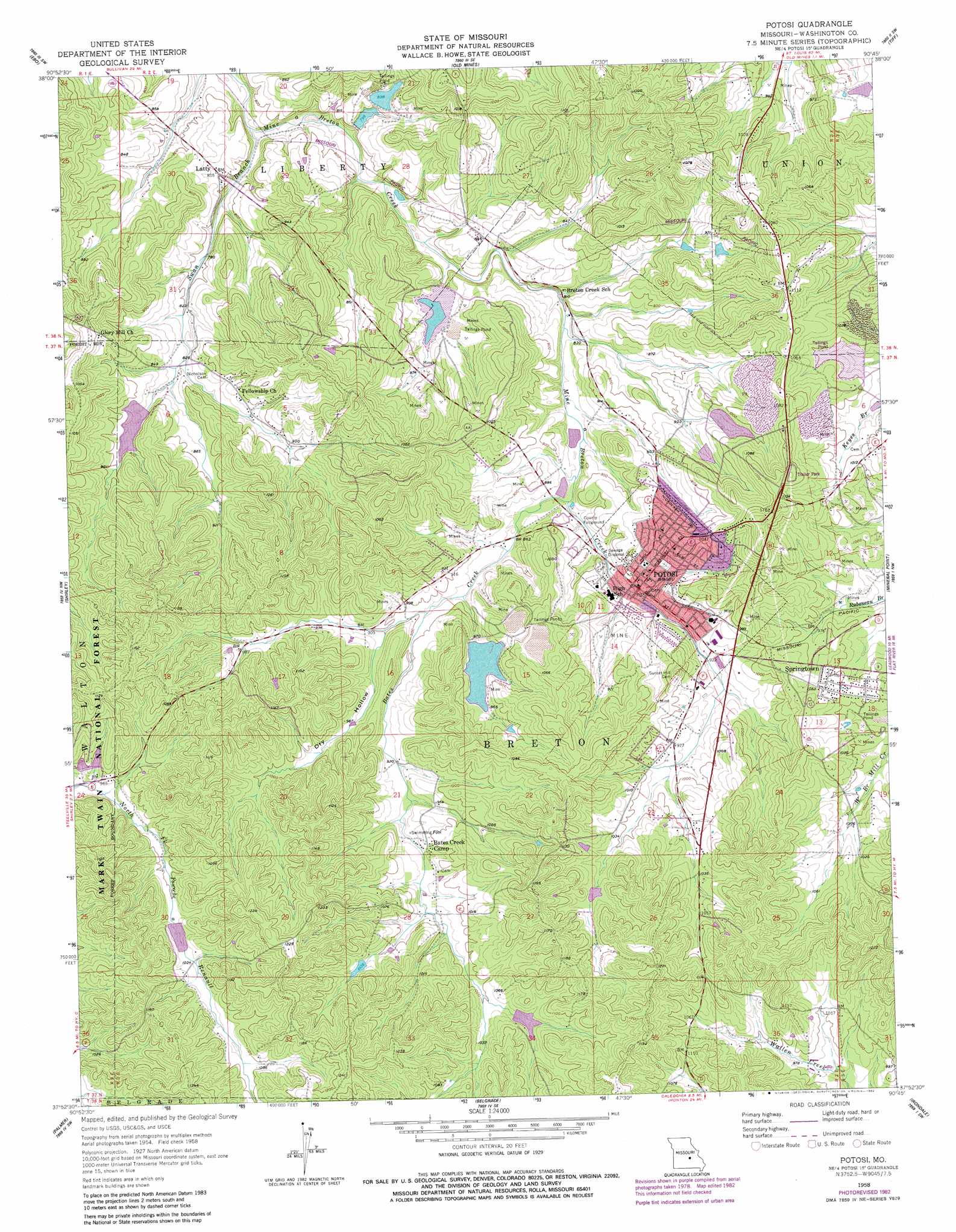
USGS Topo Quad 37090h7 - 1:24,000 scale
| Topo Map Name: | Potosi |
| USGS Topo Quad ID: | 37090h7 |
| Print Size: | ca. 21 1/4" wide x 27" high |
| Southeast Coordinates: | 37.875° N latitude / 90.75° W longitude |
| Map Center Coordinates: | 37.9375° N latitude / 90.8125° W longitude |
| U.S. State: | MO |
| Filename: | o37090h7.jpg |
| Download Map JPG Image: | Potosi topo map 1:24,000 scale |
| Map Type: | Topographic |
| Topo Series: | 7.5´ |
| Map Scale: | 1:24,000 |
| Source of Map Images: | United States Geological Survey (USGS) |
| Alternate Map Versions: |
Potosi MO 1958, updated 1959 Download PDF Buy paper map Potosi MO 1958, updated 1982 Download PDF Buy paper map Potosi MO 1958, updated 1982 Download PDF Buy paper map Potosi MO 2011 Download PDF Buy paper map Potosi MO 2015 Download PDF Buy paper map |
| FStopo: | US Forest Service topo Potosi is available: Download FStopo PDF Download FStopo TIF |
1:24,000 Topo Quads surrounding Potosi
Meramec State Park |
Cyclone Hollow |
Richwoods |
Fletcher |
Desoto |
Anthonies Mill |
Ebo |
Old Mines |
Tiff |
Vineland |
Berryman |
Shirley |
Potosi |
Mineral Point |
Bonne Terre |
Courtois |
Palmer |
Belgrade |
Irondale |
Flat River |
Viburnum East |
Johnson Mountain |
Banner |
Graniteville |
Iron Mountain Lake |
> Back to 37090e1 at 1:100,000 scale
> Back to 37090a1 at 1:250,000 scale
> Back to U.S. Topo Maps home
Potosi topo map: Gazetteer
Potosi: Dams
Bell-Settle Lake Dam elevation 286m 938′Bust Lake Dam elevation 299m 980′
Dessieux Lake Dam elevation 310m 1017′
Floyd Lake Dam elevation 273m 895′
Hornsey Brothers Dam elevation 263m 862′
Hornsey Lake Dam elevation 293m 961′
Keyes Branch Mine Dam elevation 290m 951′
Luttrell Lake Lower Dam elevation 244m 800′
Luttrell Lake Upper Dam elevation 242m 793′
Moekel Dam elevation 257m 843′
Mononame 582 Dam elevation 288m 944′
Mononame 862 Dam elevation 288m 944′
Mononame 866 Dam elevation 328m 1076′
Pine Tree Lake East Dam elevation 299m 980′
Pine Tree Lake West Dam elevation 300m 984′
Russell Elsey Dam elevation 311m 1020′
Settle Mine Dam Number 2 elevation 283m 928′
The Place Lake Dam elevation 317m 1040′
Potosi: Lakes
Elsey Lake elevation 311m 1020′Potosi: Mines
Burts Lead Diggings elevation 275m 902′Buzzard Roost Lead Diggings elevation 240m 787′
Hard Bargain Mine elevation 316m 1036′
Hinkson Lead Mine elevation 255m 836′
Negro Lead Diggings elevation 300m 984′
Post Oak Lead Diggings elevation 279m 915′
Roseberry Lead Diggings elevation 257m 843′
Potosi: Populated Places
Bates Creek Camp elevation 300m 984′Frogtown elevation 331m 1085′
Latty elevation 245m 803′
Potosi elevation 275m 902′
Springtown elevation 322m 1056′
Potosi: Reservoirs
Floyd Lake elevation 273m 895′Hornsey Brothers Lake elevation 263m 862′
Hornsey Lake elevation 293m 961′
Keyes Branch Mine Tailings Pond elevation 290m 951′
Pine Forest Lake elevation 310m 1017′
Pine Tree Lake East elevation 299m 980′
Pine Tree Lake West elevation 300m 984′
Russell Elsey Lake elevation 311m 1020′
Settle Mine Tailings Pond elevation 286m 938′
Potosi: Streams
Bates Creek elevation 255m 836′Swan Branch elevation 225m 738′
Potosi: Summits
Blackjack Hill elevation 374m 1227′Potosi: Valleys
Dry Hollow elevation 274m 898′Potosi digital topo map on disk
Buy this Potosi topo map showing relief, roads, GPS coordinates and other geographical features, as a high-resolution digital map file on DVD: