Anthonies Mill Topo Map Missouri
To zoom in, hover over the map of Anthonies Mill
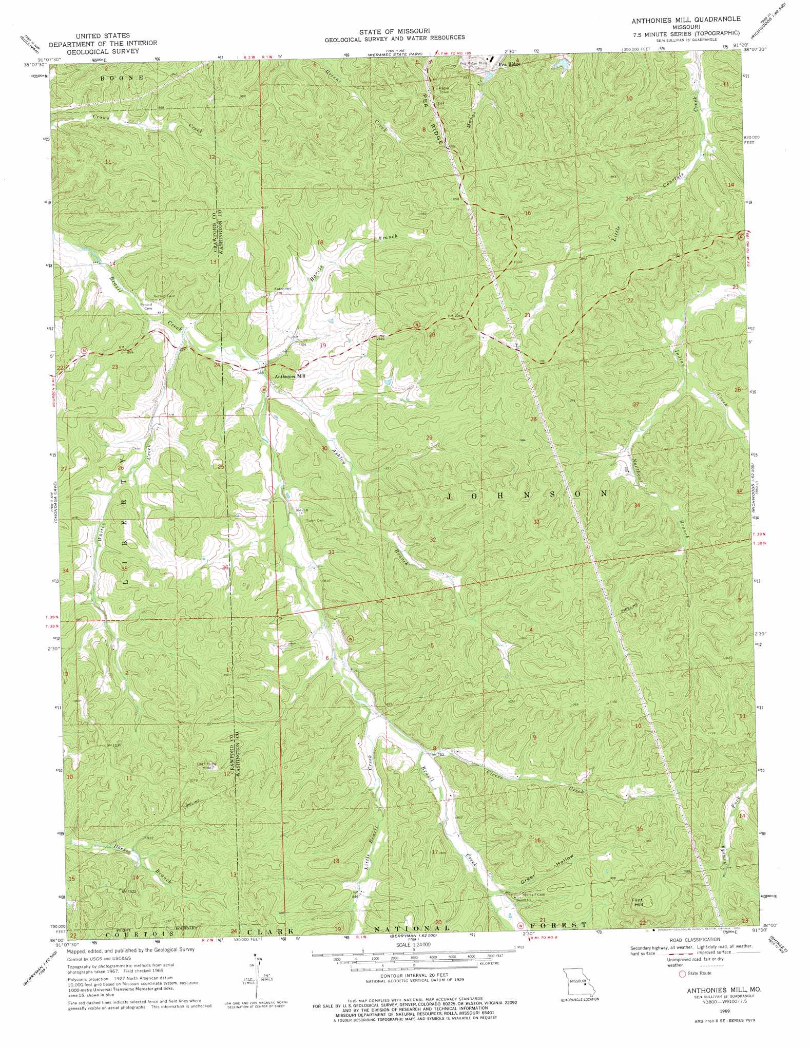
USGS Topo Quad 38091a1 - 1:24,000 scale
| Topo Map Name: | Anthonies Mill |
| USGS Topo Quad ID: | 38091a1 |
| Print Size: | ca. 21 1/4" wide x 27" high |
| Southeast Coordinates: | 38° N latitude / 91° W longitude |
| Map Center Coordinates: | 38.0625° N latitude / 91.0625° W longitude |
| U.S. State: | MO |
| Filename: | o38091a1.jpg |
| Download Map JPG Image: | Anthonies Mill topo map 1:24,000 scale |
| Map Type: | Topographic |
| Topo Series: | 7.5´ |
| Map Scale: | 1:24,000 |
| Source of Map Images: | United States Geological Survey (USGS) |
| Alternate Map Versions: |
Anthonies Mill MO 1969, updated 1971 Download PDF Buy paper map Anthonies Mill MO 1969, updated 1976 Download PDF Buy paper map Anthonies Mill MO 1969, updated 1976 Download PDF Buy paper map Anthonies Mill MO 2012 Download PDF Buy paper map Anthonies Mill MO 2015 Download PDF Buy paper map |
| FStopo: | US Forest Service topo Anthonies Mill is available: Download FStopo PDF Download FStopo TIF |
1:24,000 Topo Quads surrounding Anthonies Mill
Strain |
Spring Bluff |
Stanton |
Saint Clair |
Lonedell |
Argo |
Sullivan |
Meramec State Park |
Cyclone Hollow |
Richwoods |
Leasburg |
Onondaga Cave |
Anthonies Mill |
Ebo |
Old Mines |
Steelville |
Huzzah |
Berryman |
Shirley |
Potosi |
Cherryville |
Davisville |
Courtois |
Palmer |
Belgrade |
> Back to 38091a1 at 1:100,000 scale
> Back to 38090a1 at 1:250,000 scale
> Back to U.S. Topo Maps home
Anthonies Mill topo map: Gazetteer
Anthonies Mill: Dams
Dellistri Dam elevation 286m 938′Hematite Lake Dam elevation 243m 797′
Pea Ridge Incorporated Lake Dam elevation 257m 843′
Anthonies Mill: Mines
Old Christy Mine elevation 288m 944′Weins Lead Diggings elevation 321m 1053′
Anthonies Mill: Populated Places
Anthonies Mill elevation 218m 715′Anthonies Mill: Reservoirs
Dellistri Lake elevation 286m 938′Anthonies Mill: Springs
Grant Spring (historical) elevation 297m 974′Anthonies Mill: Streams
Ashley Branch elevation 206m 675′Cicero Creek elevation 235m 770′
Harris Branch elevation 206m 675′
Little Brazil Creek elevation 234m 767′
Northcut Branch elevation 226m 741′
Whites Creek elevation 201m 659′
Anthonies Mill: Summits
Flint Hill elevation 403m 1322′Anthonies Mill: Valleys
Grady Mill Hollow elevation 285m 935′Greer Hollow elevation 256m 839′
Anthonies Mill digital topo map on disk
Buy this Anthonies Mill topo map showing relief, roads, GPS coordinates and other geographical features, as a high-resolution digital map file on DVD: