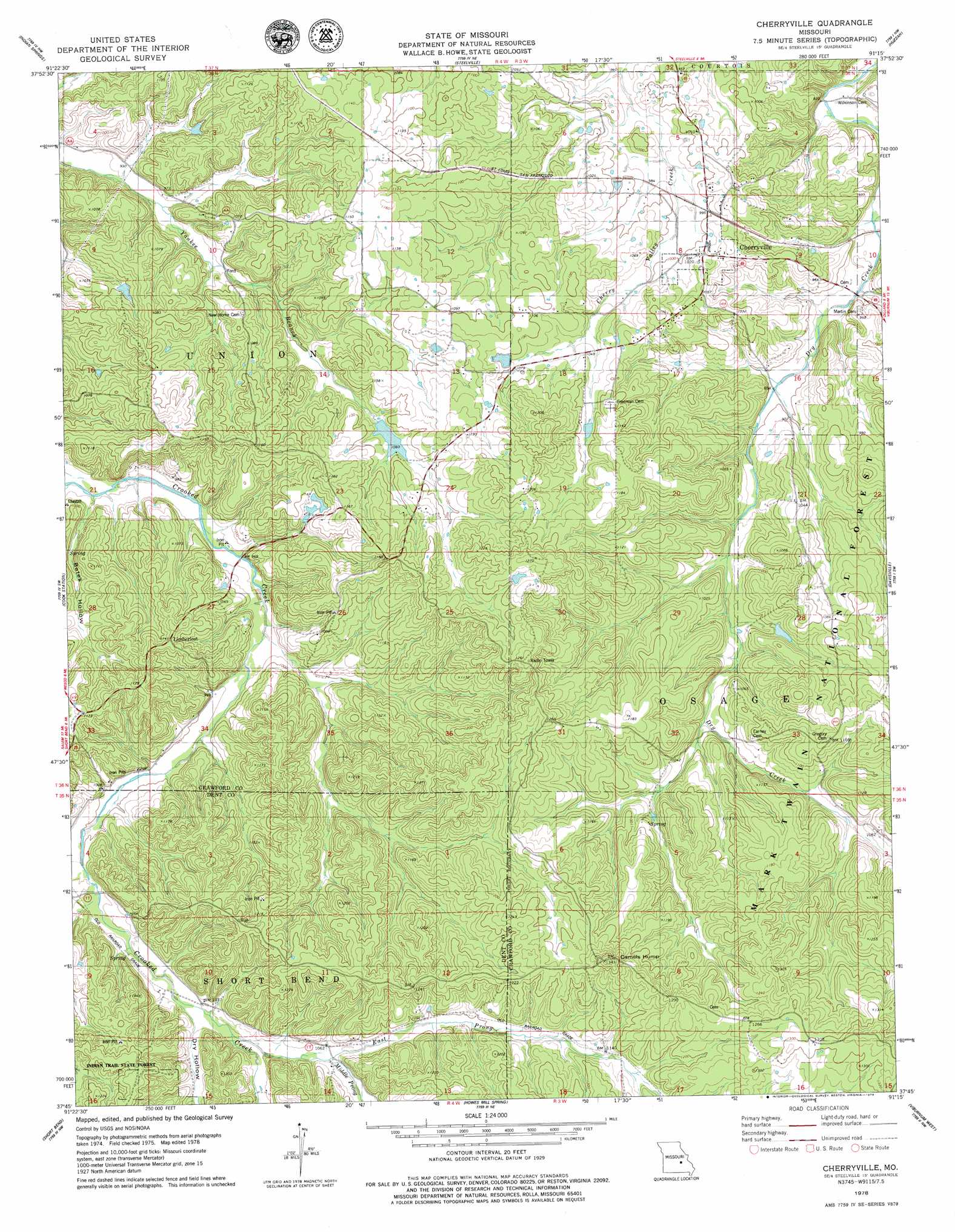
Cherryville Topo Map Missouri
To zoom in, hover over the map of Cherryville
USGS Topo Quad 37091g3 - 1:24,000 scale
| Topo Map Name: | Cherryville |
| USGS Topo Quad ID: | 37091g3 |
| Print Size: | ca. 21 1/4" wide x 27" high |
| Southeast Coordinates: | 37.75° N latitude / 91.25° W longitude |
| Map Center Coordinates: | 37.8125° N latitude / 91.3125° W longitude |
| U.S. State: | MO |
| Filename: | o37091g3.jpg |
| Download Map JPG Image: | Cherryville topo map 1:24,000 scale |
| Map Type: | Topographic |
| Topo Series: | 7.5´ |
| Map Scale: | 1:24,000 |
| Source of Map Images: | United States Geological Survey (USGS) |
| Alternate Map Versions: |
Cherryville MO 1978, updated 1979 Download PDF Buy paper map Cherryville MO 2012 Download PDF Buy paper map Cherryville MO 2015 Download PDF Buy paper map |
| FStopo: | US Forest Service topo Cherryville is available: Download FStopo PDF Download FStopo TIF |
1:24,000 Topo Quads surrounding Cherryville
Rosati |
Cuba |
Leasburg |
Onondaga Cave |
Anthonies Mill |
Maramec Spring |
Indian Springs |
Steelville |
Huzzah |
Berryman |
Seaton |
Cook Station |
Cherryville |
Davisville |
Courtois |
Salem |
Short Bend |
Howes Mill Spring |
Viburnum West |
Viburnum East |
Darien |
Doss |
Stone Hill |
Greeley |
Oates |
> Back to 37091e1 at 1:100,000 scale
> Back to 37090a1 at 1:250,000 scale
> Back to U.S. Topo Maps home
Cherryville topo map: Gazetteer
Cherryville: Dams
Asher Lake Dam elevation 283m 928′Ballard Lake Section 13 Dam elevation 335m 1099′
Ballard Lake Section 14 Dam elevation 323m 1059′
Geize Lake Dam elevation 372m 1220′
Hubbman Lake Dam elevation 274m 898′
Cherryville: Mines
Anderson Iron Bank elevation 338m 1108′Carson Iron Banks elevation 399m 1309′
Dry Creek Iron Bank elevation 289m 948′
Eaton Lead Mine elevation 271m 889′
Hibler Iron Bank elevation 301m 987′
Key and Anderson Iron Mine elevation 321m 1053′
Key Iron Bank elevation 314m 1030′
Mountain Iron Mine elevation 381m 1250′
Rees Iron Mine elevation 309m 1013′
Rovald Iron Mine elevation 329m 1079′
Thompson Iron Mine elevation 311m 1020′
Wilkerson Iron Bank elevation 298m 977′
Cherryville: Populated Places
Cherryville elevation 311m 1020′Limberlost elevation 349m 1145′
Cherryville: Reservoirs
Ballard Lake Section 13 elevation 335m 1099′Ballard Lake Section 14 elevation 323m 1059′
Geize Lake elevation 372m 1220′
Hubbman Lake elevation 274m 898′
Cherryville: Streams
East Prong Crooked Creek elevation 315m 1033′Middle Prong Crooked Creek elevation 320m 1049′
Cherryville: Summits
Camels Hump elevation 406m 1332′Cherryville: Valleys
Bates Hollow elevation 286m 938′Dry Hollow elevation 315m 1033′
Cherryville digital topo map on disk
Buy this Cherryville topo map showing relief, roads, GPS coordinates and other geographical features, as a high-resolution digital map file on DVD: