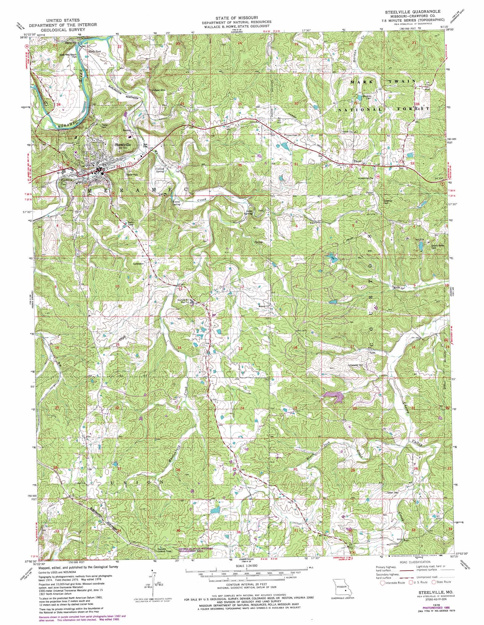
Steelville Topo Map Missouri
To zoom in, hover over the map of Steelville
USGS Topo Quad 37091h3 - 1:24,000 scale
| Topo Map Name: | Steelville |
| USGS Topo Quad ID: | 37091h3 |
| Print Size: | ca. 21 1/4" wide x 27" high |
| Southeast Coordinates: | 37.875° N latitude / 91.25° W longitude |
| Map Center Coordinates: | 37.9375° N latitude / 91.3125° W longitude |
| U.S. State: | MO |
| Filename: | o37091h3.jpg |
| Download Map JPG Image: | Steelville topo map 1:24,000 scale |
| Map Type: | Topographic |
| Topo Series: | 7.5´ |
| Map Scale: | 1:24,000 |
| Source of Map Images: | United States Geological Survey (USGS) |
| Alternate Map Versions: |
Steelville MO 1978, updated 1979 Download PDF Buy paper map Steelville MO 1978, updated 1985 Download PDF Buy paper map Steelville MO 1978, updated 1985 Download PDF Buy paper map Steelville MO 1999, updated 2002 Download PDF Buy paper map Steelville MO 2011 Download PDF Buy paper map Steelville MO 2015 Download PDF Buy paper map |
| FStopo: | US Forest Service topo Steelville is available: Download FStopo PDF Download FStopo TIF |
1:24,000 Topo Quads surrounding Steelville
Redbird |
Oak Hill |
Argo |
Sullivan |
Meramec State Park |
Rosati |
Cuba |
Leasburg |
Onondaga Cave |
Anthonies Mill |
Maramec Spring |
Indian Springs |
Steelville |
Huzzah |
Berryman |
Seaton |
Cook Station |
Cherryville |
Davisville |
Courtois |
Salem |
Short Bend |
Howes Mill Spring |
Viburnum West |
Viburnum East |
> Back to 37091e1 at 1:100,000 scale
> Back to 37090a1 at 1:250,000 scale
> Back to U.S. Topo Maps home
Steelville topo map: Gazetteer
Steelville: Dams
Carden Lake Dam elevation 282m 925′Cardin Lake Dam elevation 265m 869′
Field Lake Dam elevation 282m 925′
Helmering Farms Dam elevation 317m 1040′
Mononame 133 Dam elevation 298m 977′
Mononame 852 Dam elevation 283m 928′
Steelville: Mines
Cherry Valley Number One Iron Bank elevation 260m 853′Cherry Valley Number Two Iron Bank elevation 288m 944′
Clark Iron Mine elevation 269m 882′
Ferguson Iron Bank elevation 310m 1017′
Halbert Lead Digging elevation 285m 935′
Midland Mine elevation 239m 784′
N.G. Clark Number One Iron Bank elevation 256m 839′
Peetz Iron Bank elevation 259m 849′
Steelville: Parks
Birds Nest Beach Park elevation 213m 698′Steelville: Populated Places
Birds Nest elevation 213m 698′Cherry Valley elevation 313m 1026′
Elaver elevation 317m 1040′
Midland elevation 270m 885′
Patsy elevation 319m 1046′
Sankey (historical) elevation 221m 725′
Steelville elevation 228m 748′
Wildwoods elevation 233m 764′
Steelville: Reservoirs
Carden Lake elevation 282m 925′Cardin Lake elevation 265m 869′
Field Lake elevation 282m 925′
Helmering Farms Lake elevation 317m 1040′
Steelville: Springs
Big Spring elevation 235m 770′Collins Spring elevation 226m 741′
Evans Spring elevation 237m 777′
Long Spring elevation 246m 807′
Steelville: Streams
Black Jack Creek elevation 250m 820′Whittenburg Creek elevation 208m 682′
Steelville digital topo map on disk
Buy this Steelville topo map showing relief, roads, GPS coordinates and other geographical features, as a high-resolution digital map file on DVD: