Mancos Topo Map Colorado
To zoom in, hover over the map of Mancos
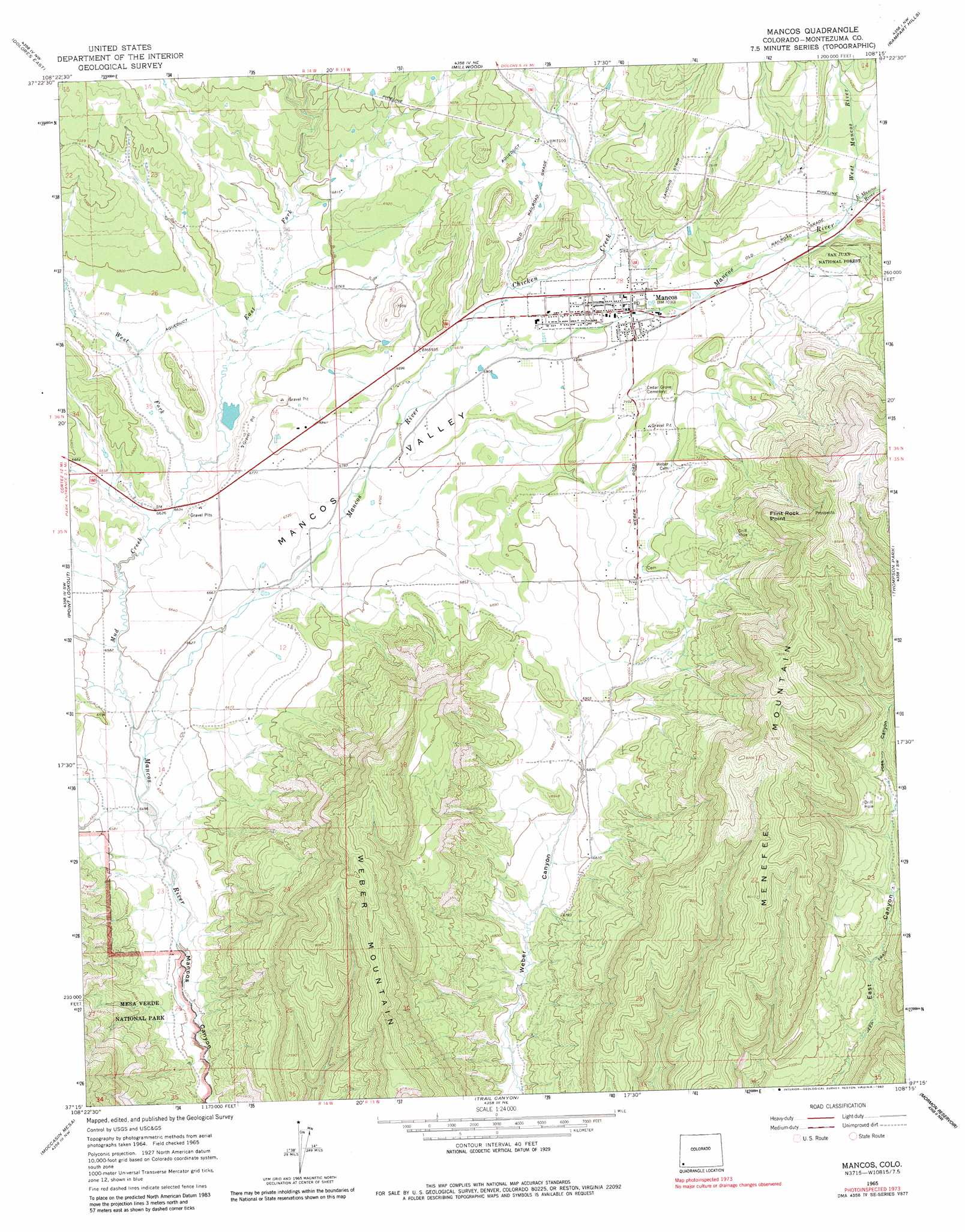
USGS Topo Quad 37108c3 - 1:24,000 scale
| Topo Map Name: | Mancos |
| USGS Topo Quad ID: | 37108c3 |
| Print Size: | ca. 21 1/4" wide x 27" high |
| Southeast Coordinates: | 37.25° N latitude / 108.25° W longitude |
| Map Center Coordinates: | 37.3125° N latitude / 108.3125° W longitude |
| U.S. State: | CO |
| Filename: | o37108c3.jpg |
| Download Map JPG Image: | Mancos topo map 1:24,000 scale |
| Map Type: | Topographic |
| Topo Series: | 7.5´ |
| Map Scale: | 1:24,000 |
| Source of Map Images: | United States Geological Survey (USGS) |
| Alternate Map Versions: |
Mancos CO 1965, updated 1968 Download PDF Buy paper map Mancos CO 1965, updated 1968 Download PDF Buy paper map Mancos CO 1965, updated 1983 Download PDF Buy paper map Mancos CO 2010 Download PDF Buy paper map Mancos CO 2013 Download PDF Buy paper map Mancos CO 2016 Download PDF Buy paper map |
1:24,000 Topo Quads surrounding Mancos
Trimble Point |
Boggy Draw |
Stoner |
Wallace Ranch |
Orphan Butte |
Dolores West |
Dolores East |
Millwood |
Rampart Hills |
La Plata |
Cortez |
Point Lookout |
Mancos |
Thompson Park |
Hesperus |
Wetherill Mesa |
Moccasin Mesa |
Trail Canyon |
Mormon Reservoir |
Kline |
Moqui Canyon |
Greasewood Canyon |
Red Horse Gulch |
Redmesa |
Pinkerton Mesa |
> Back to 37108a1 at 1:100,000 scale
> Back to 37108a1 at 1:250,000 scale
> Back to U.S. Topo Maps home
Mancos topo map: Gazetteer
Mancos: Cliffs
East Rim elevation 2185m 7168′Flint Rock Point elevation 2511m 8238′
Mancos: Mines
Burnham Mine elevation 2555m 8382′Fielding-Spencer Mine elevation 2495m 8185′
Old Spencer Mine elevation 2408m 7900′
Todd Mine elevation 2279m 7477′
Mancos: Parks
Mancos Wayside Park elevation 2145m 7037′Mancos: Populated Places
Mancos elevation 2142m 7027′Weber elevation 2180m 7152′
Mancos: Post Offices
Mancos Post Office elevation 2144m 7034′Mancos: Reservoirs
Lower Weber Reservoir elevation 2146m 7040′Mancos: Streams
Chicken Creek elevation 2074m 6804′East Fork Mud Creek elevation 2016m 6614′
East Mancos River elevation 2207m 7240′
West Fork Mud Creek elevation 2016m 6614′
West Mancos River elevation 2207m 7240′
Mancos: Summits
Weber Mountain elevation 2503m 8211′Mancos: Valleys
Joes Canyon elevation 2174m 7132′Mancos Valley elevation 1978m 6489′
Mancos digital topo map on disk
Buy this Mancos topo map showing relief, roads, GPS coordinates and other geographical features, as a high-resolution digital map file on DVD: