Barker Reservoir Topo Map Utah
To zoom in, hover over the map of Barker Reservoir
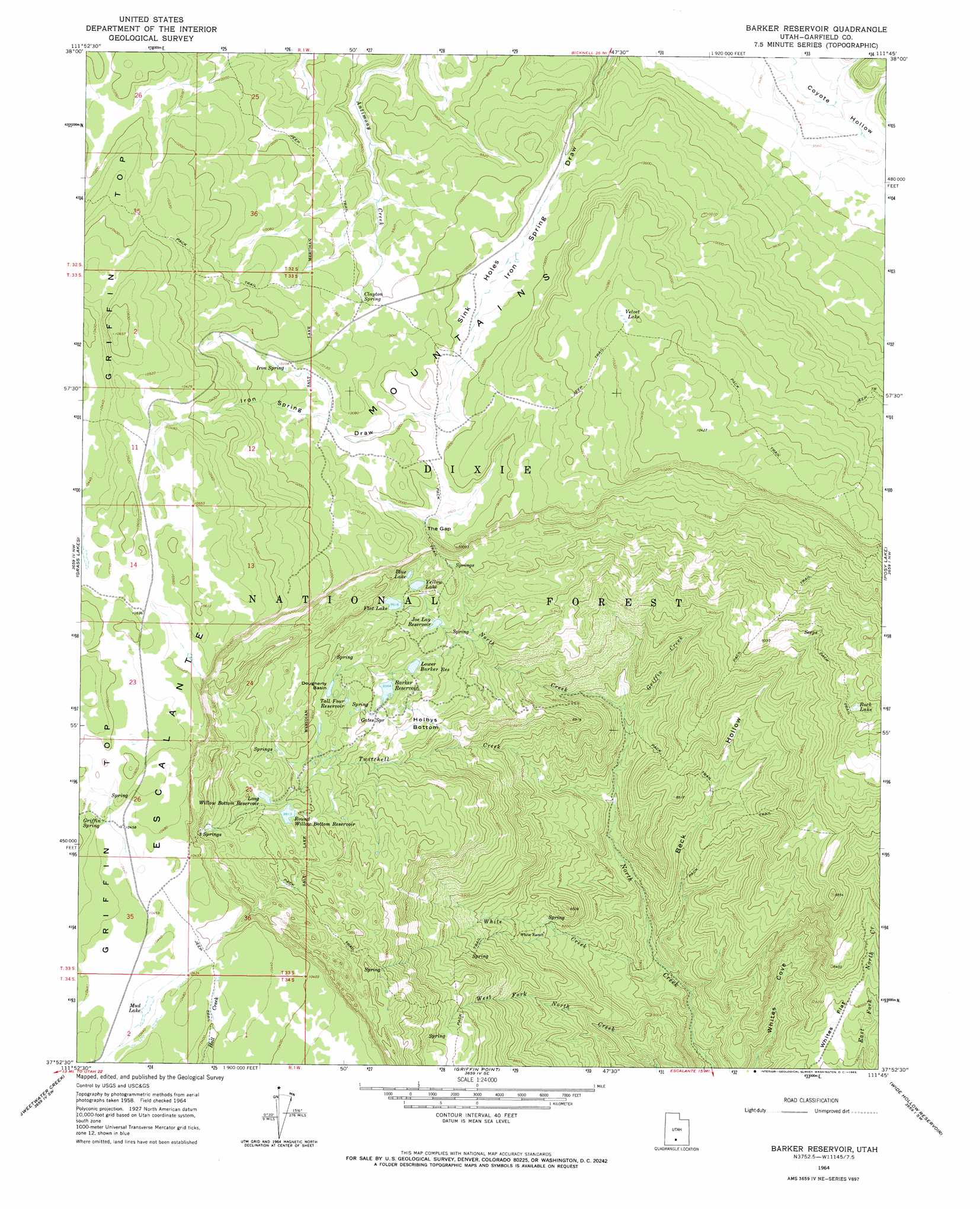
USGS Topo Quad 37111h7 - 1:24,000 scale
| Topo Map Name: | Barker Reservoir |
| USGS Topo Quad ID: | 37111h7 |
| Print Size: | ca. 21 1/4" wide x 27" high |
| Southeast Coordinates: | 37.875° N latitude / 111.75° W longitude |
| Map Center Coordinates: | 37.9375° N latitude / 111.8125° W longitude |
| U.S. State: | UT |
| Filename: | o37111h7.jpg |
| Download Map JPG Image: | Barker Reservoir topo map 1:24,000 scale |
| Map Type: | Topographic |
| Topo Series: | 7.5´ |
| Map Scale: | 1:24,000 |
| Source of Map Images: | United States Geological Survey (USGS) |
| Alternate Map Versions: |
Barker Reservoir UT 1964, updated 1965 Download PDF Buy paper map Barker Reservoir UT 2002, updated 2005 Download PDF Buy paper map Barker Reservoir UT 2011 Download PDF Buy paper map Barker Reservoir UT 2014 Download PDF Buy paper map |
| FStopo: | US Forest Service topo Barker Reservoir is available: Download FStopo PDF Download FStopo TIF |
1:24,000 Topo Quads surrounding Barker Reservoir
Phonolite Hill |
Angle |
Flossie Knoll |
Smooth Knoll |
Government Point |
Deep Creek |
Antimony |
Pollywog Lake |
Big Lake |
Jacobs Reservoir |
Cow Creek |
Grass Lakes |
Barker Reservoir |
Posy Lake |
Roger Peak |
Flake Mountain East |
Sweetwater Creek |
Griffin Point |
Wide Hollow Reservoir |
Escalante |
Tropic Canyon |
Pine Lake |
Upper Valley |
Canaan Creek |
Dave Canyon |
> Back to 37111e1 at 1:100,000 scale
> Back to 37110a1 at 1:250,000 scale
> Back to U.S. Topo Maps home
Barker Reservoir topo map: Gazetteer
Barker Reservoir: Basins
Dougherty Basin elevation 2971m 9747′Barker Reservoir: Bends
Holbys Bottom elevation 2843m 9327′Sink Holes elevation 3030m 9940′
Barker Reservoir: Dams
Barker Dam elevation 2917m 9570′Long Willow Bottom Dam elevation 3010m 9875′
Lower Barker Dam elevation 2882m 9455′
Barker Reservoir: Flats
Whites Flat elevation 2419m 7936′Barker Reservoir: Gaps
The Gap elevation 3011m 9878′Barker Reservoir: Lakes
Blue Lake elevation 2938m 9639′Flat Lake elevation 2935m 9629′
Mud Lake elevation 3180m 10433′
Rock Lake elevation 2828m 9278′
Yellow Lake elevation 2937m 9635′
Barker Reservoir: Ranges
Escalante Mountains elevation 3233m 10606′Barker Reservoir: Reservoirs
Barker Reservoir elevation 2914m 9560′Joe Lay Reservoir elevation 2887m 9471′
Long Willow Bottom Reservoir elevation 3007m 9865′
Lower Barker Reservoir elevation 2879m 9445′
Round Willow Bottom Reservoir elevation 2999m 9839′
Tall Four Reservoir elevation 2950m 9678′
Barker Reservoir: Springs
Clayton Spring elevation 3056m 10026′Gates Spring elevation 2906m 9534′
Gibbons Springs elevation 2920m 9580′
Griffin Spring elevation 3197m 10488′
Iron Spring elevation 3078m 10098′
Three Springs elevation 3100m 10170′
Barker Reservoir: Streams
Griffin Creek elevation 2496m 8188′Twitchell Creek elevation 2437m 7995′
White Creek elevation 2341m 7680′
Barker Reservoir: Swamps
Velvet Lake elevation 3164m 10380′Barker Reservoir: Valleys
Beck Hollow elevation 2319m 7608′Indian Spring Draw elevation 2902m 9520′
Barker Reservoir digital topo map on disk
Buy this Barker Reservoir topo map showing relief, roads, GPS coordinates and other geographical features, as a high-resolution digital map file on DVD: