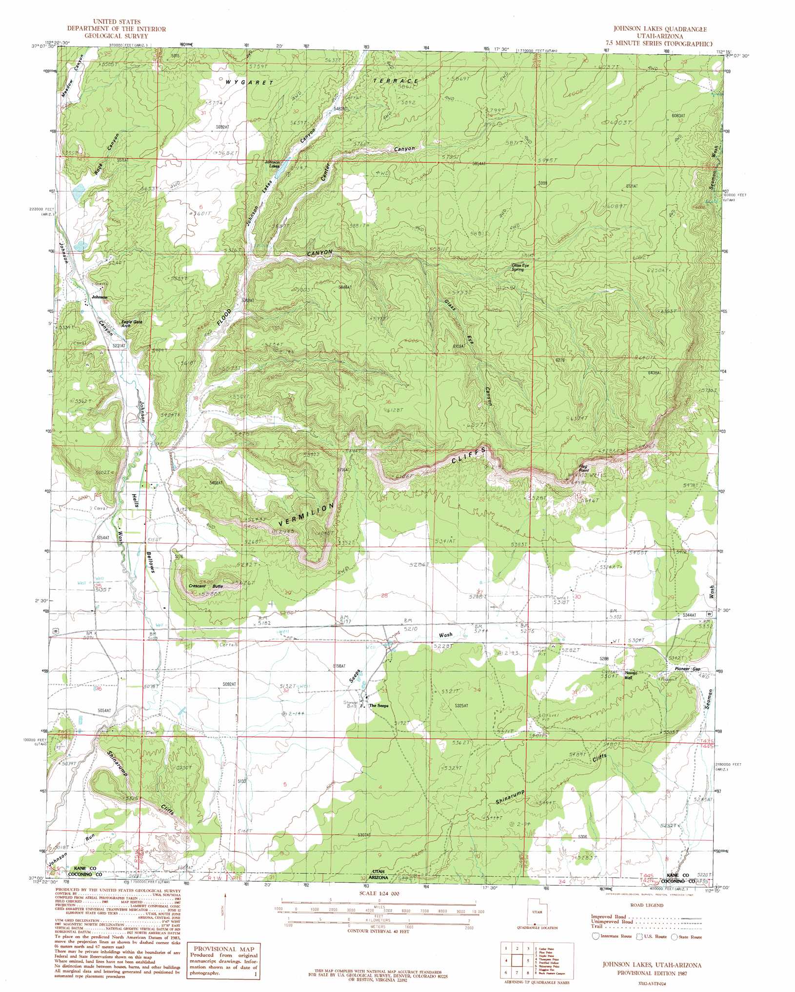
Johnson Lakes Topo Map Utah
To zoom in, hover over the map of Johnson Lakes
USGS Topo Quad 37112a3 - 1:24,000 scale
| Topo Map Name: | Johnson Lakes |
| USGS Topo Quad ID: | 37112a3 |
| Print Size: | ca. 21 1/4" wide x 27" high |
| Southeast Coordinates: | 37° N latitude / 112.25° W longitude |
| Map Center Coordinates: | 37.0625° N latitude / 112.3125° W longitude |
| U.S. States: | UT, AZ |
| Filename: | o37112a3.jpg |
| Download Map JPG Image: | Johnson Lakes topo map 1:24,000 scale |
| Map Type: | Topographic |
| Topo Series: | 7.5´ |
| Map Scale: | 1:24,000 |
| Source of Map Images: | United States Geological Survey (USGS) |
| Alternate Map Versions: |
Johnson SE UT 1954, updated 1956 Download PDF Buy paper map Johnson Lakes UT 1987, updated 1987 Download PDF Buy paper map Johnson Lakes UT 2011 Download PDF Buy paper map Johnson Lakes UT 2014 Download PDF Buy paper map |
1:24,000 Topo Quads surrounding Johnson Lakes
Glendale |
Bald Knoll |
Skutumpah Creek |
Deer Spring Point |
Deer Range Point |
White Tower |
Cutler Point |
Pine Point |
Nephi Point |
Eightmile Pass |
Kanab |
Thompson Point |
Johnson Lakes |
Petrified Hollow |
Pine Hollow Canyon |
Fredonia |
Shinarump Point |
Muggins Flat |
Buck Pasture Canyon |
Coyote Buttes |
Clear Water Spring |
White Sage Flat |
Le Fevre Ridge |
Cooper Ridge |
House Rock Spring |
> Back to 37112a1 at 1:100,000 scale
> Back to 37112a1 at 1:250,000 scale
> Back to U.S. Topo Maps home
Johnson Lakes topo map: Gazetteer
Johnson Lakes: Basins
Hells Bellows elevation 1572m 5157′Johnson Lakes: Capes
Flag Point elevation 1976m 6482′Johnson Lakes: Cliffs
Shinarump Cliffs elevation 1611m 5285′Johnson Lakes: Flats
Muggins Flat elevation 1531m 5022′Johnson Lakes: Gaps
Pioneer Gap elevation 1633m 5357′Johnson Lakes: Lakes
Johnson Lakes elevation 1666m 5465′Johnson Lakes: Springs
The Seeps elevation 1577m 5173′Johnson Lakes: Summits
Crescent Butte elevation 1692m 5551′Dishopan Hill elevation 1713m 5620′
Johnson Lakes: Valleys
Center Canyon elevation 1631m 5351′Flood Canyon elevation 1581m 5187′
Glass Eye Canyon elevation 1709m 5606′
Johnson Canyon elevation 1602m 5255′
Johnson Lakes Canyon elevation 1621m 5318′
Rock Canyon elevation 1630m 5347′
Johnson Lakes: Wells
Navajo Well elevation 1632m 5354′Johnson Lakes digital topo map on disk
Buy this Johnson Lakes topo map showing relief, roads, GPS coordinates and other geographical features, as a high-resolution digital map file on DVD: